Heavy Ohio Storm Causes Flash Floods, Minor River Rise, Cold Front Arrives
Updated (2 articles)
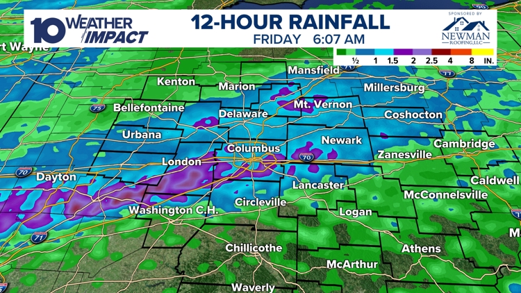
Storm System Brings Over Two Inches Rainfall strong storm system moved across Ohio Thursday evening into Friday morning, producing numerous showers and thunderstorms with radar‑estimated rainfall exceeding 2 inches in many locations. Rain totals topped 1.5 inches, with 1.76 in recorded in Newark and 1.68 in in Columbus, prompting immediate concerns about water accumulation [1]. The intense precipitation persisted through the early morning hours before the rain began to subside [1].
Flash Flooding Impacts Streets and Creeks Street flooding and flash flooding were reported as rain totals topped 1.5 inches, causing water to pool on roadways and low‑lying areas [1]. Raccoon Creek near Granville reached minor flood stage, reflecting the rapid runoff from the storm [1]. Conditions improved after the rain cleared, and officials monitored creek levels for any further rise [1].
Cold Front Triggers Strong Winds and Temperature Drop Following the storm, a strong cold front is forecast to generate wind gusts exceeding 40 mph [1]. The front will also produce a significant temperature drop through Friday, ushering in colder weather for the weekend [1]. Meteorologists highlighted the front’s role in ending the heavy rain and transitioning the region to cooler conditions [1].
Future Weather Outlook Includes Snow and Dry Spell Meteorologists anticipate snow showers on Sunday, providing the first wintry precipitation after the storm [1]. The next period of rain is not expected until the middle of the following week, indicating a brief dry spell [1]. Residents are encouraged to email rainfall measurements to [email protected] to aid real‑time tracking of the event [1].
Timeline
2024 – Researcher Sebastian Harkema leads a NASA Center for Climate Simulation study that finds thundersnow occurs more frequently than historically believed, especially in the eastern Great Lakes region and Japan, stating “the event is more frequent than historically believed” [1].
2026 (general) – NASA defines thundersnow as simultaneous snowfall and lightning, calling it “one of the more dramatic and relatively rare weather phenomena,” underscoring its scientific rarity [1].
Jan 21, 2026 – Rich Pawlewski records thundersnow at 9:54 p.m. in Marilla, NY, capturing heavy snow with lightning and thunder; he later tells Newsweek that “thundersnow occurs in Western New York about once a year but is rarely recorded because it is random” [1].
Jan 22, 2026 – A TikTok video posted shows snow covering cars and a sudden bolt of lightning during the same storm, quickly gaining over 18,000 views and illustrating the rarity of simultaneous snow and lightning [1].
Jan 27, 2026 – The National Weather Service warns that an arctic air mass will move from the Plains into the Eastern and Southeast U.S. Friday‑through‑Saturday, bringing well‑below‑normal temperatures and potential record lows as far south as Florida [1].
Feb 19, 2026 – A strong storm system sweeps across Ohio, delivering heavy showers and thunderstorms that produce radar‑estimated rainfall exceeding 2 inches in many locations, setting the stage for flash flooding [2].
Feb 20, 2026 – Flash flooding erupts as rain totals top 1.5 inches, with Newark reporting 1.76 in and Columbus 1.68 in; Raccoon Creek near Granville reaches minor flood stage, and forecasters anticipate a strong cold front to bring wind gusts over 40 mph and a sharp temperature drop through Friday [2].
Feb 22, 2026 – Meteorologists forecast snow showers across Ohio on Sunday, marking a brief transition from rain to wintry precipitation before the next rain period arrives mid‑next week [2].
Mid‑week, Feb 2026 – Forecasts predict the next period of rain will not occur until the middle of the following week, indicating a short dry spell after the snow showers [2].
All related articles (2 articles)
External resources (6 links)
- http://instagram.com/aaronwhitetv/ (cited 1 times)
- http://x.com/aaronwhitetv (cited 1 times)
- https://www.facebook.com/AaronWhiteTV/ (cited 1 times)
- https://www.tiktok.com/@dewpointdoyle4/video/7598015058613964087 (cited 1 times)
- https://www.tiktok.com/@pawlew3/video/7598026701313936654 (cited 1 times)
- https://agupubs.onlinelibrary.wiley.com/doi/10.1029/2023JD039987 (cited 1 times)