Central Ohio Faces Flood Risk as Storm System Sweeps Through Thursday Night
Updated (54 articles)
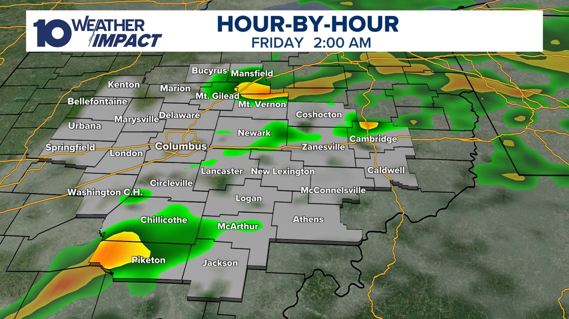
Storm System Entered Central Ohio Thursday Night The system moved into central Ohio Thursday night after producing severe weather to the south and west earlier, bringing warm, moist air that fueled showers and thunderstorms around 9 p.m. The strongest storms developed near the leading edge, while the primary threat shifted to heavy rain overnight[1][2].
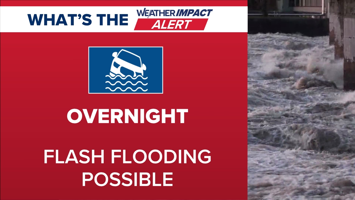
10TV Weather Impact Alert Day Remains Active Through Night 10TV Weather Impact Alert Day was issued and stayed in effect through Thursday night, warning of ongoing severe‑weather potential. County alerts in Fayette and Madison moved from wind and hail to flooding, with warnings active until 2 a.m. and hazardous travel conditions advised[1][2].
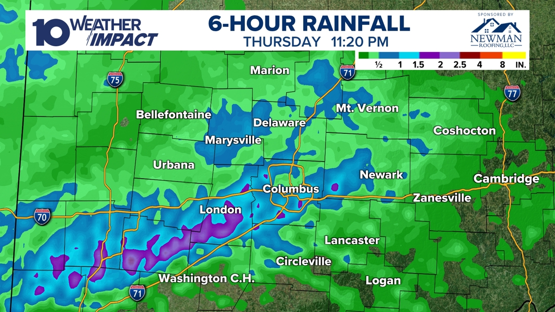
Rainfall Exceeds Two Inches, Flash Flooding Expected Radar estimated rainfall totals over 2 inches in several locations by 11:20 p.m. Thursday, prompting flash‑flooding concerns especially in Fayette and Madison counties. Heavy rain was expected to continue into early Friday before storms waned before sunrise[1][2].
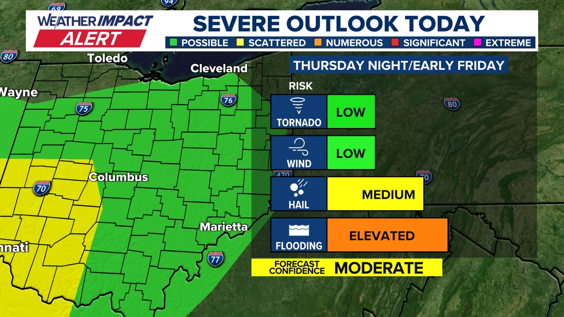
Marginal Level‑One Severe Weather Risk Includes Isolated Tornado Possibility Atmospheric analysis showed a low‑pressure system, advancing warm front, and approaching cold front with moderate wind shear, creating a level‑1 of 5 severe‑weather risk for central Ohio. Risk increased farther west, and an isolated tornado could not be ruled out[1][2].
Gusty Winds Persist Friday, Snow Showers Possible Sunday Showers and storms were forecast to end before sunrise Friday, but gusty winds were expected to linger into the day. Temperatures were projected to fall, with a chance of snow showers returning by Sunday[1][2].
Sources
-
1.
WBNS (Columbus, OH): Strong Storm System Brings Severe Weather and Flood Risk to Central Ohio: details the storm’s arrival Thursday night, alerts, shift to flooding, rainfall totals exceeding two inches, and forecasts of lingering gusty winds and possible snow showers.
-
2.
WBNS (Columbus, OH): Strong Storm System Moves Through Central Ohio Thursday Night: emphasizes timing of thunderstorms around 9 p.m., county warnings, atmospheric setup, and flash‑flooding expectations.
-
3.
WBNS (Columbus, OH): Dense Fog Advisory Triggers Weather Impact Alert for Central Ohio Tuesday: reports a dense fog advisory on Tuesday, causes of fog, reduced visibility, and the upcoming warm storm and cooling front later in the week.
Related Tickers
Timeline
Dec 2, 2025 – Columbus receives more than 4 inches of snow as part of a 3‑6‑inch event across central Ohio; Franklin County declares Level 2 and Level 3 snow emergencies, and officials warn temperatures will stay below freezing through the week[26].
Dec 2, 2025 – Columbus City Schools cancel all classes and extracurricular activities for Tuesday because overnight snow makes roads slick and unsafe[28].
Dec 2, 2025 – Franklin County courts close on Tuesday after 2‑4 inches of snow fall overnight, and multiple school districts also suspend classes due to hazardous conditions[30].
Dec 2, 2025 – Central Ohio schools report 3‑5 inches of snow Tuesday morning, with Worthington seeing over 6 inches; winter weather advisories are lifted as the system moves out[27].
Dec 5, 2025 – Record low wind‑chill values hit parts of Ohio, dropping below any previous readings for the season as single‑digit temperatures combine with strong winds[25].
Dec 11‑14, 2025 – A Saturday snowstorm drops up to 9 inches, followed by 25 mph winds that produce blowing snow and wind chills near or below 0°F; several counties issue snow emergencies and cold‑weather advisories[24].
Dec 15, 2025 – Columbus City Schools cancel Monday’s classes and activities, citing slippery roads from Saturday’s snow and sub‑zero wind chills expected through the morning[23].
Dec 21, 2025 – The winter solstice brings typical Columbus highs near 40°F and lows near 26°F; the historic record snowfall on a solstice is 4.3 inches (1981), and forecasters expect a mild Christmas week with temperatures rising into the 50‑60°F range[22].
Dec 29, 2025 – A strong low‑pressure system drives 40‑50 mph gusts across central Ohio on Monday, prompting a Weather Impact Alert Day and warnings to secure outdoor items and expect possible power outages[21].
Jan 21‑22, 2026 – A Winter Storm Watch covers six southern Ohio counties, forecasting snow and subzero wind chills through the weekend; the 10TV Weather Impact Team issues alert days from Friday night through Monday morning[20].
Jan 23, 2026 – Governor Mike DeWine urges Ohioans to stay home as a 6‑12‑inch snow event approaches, while ODOT readies 1,500 trucks and 3,000 workers to treat 43,000 lane miles[19].
Jan 24, 2026 – Mayor Andrew Ginther briefs residents on the impending storm, noting the Snow Warriors will clear 8‑12 inches, a Winter Storm Warning predicts up to 12 inches, and wind chills could reach ‑5 to ‑15°F; ODOT deploys 1,500 trucks and 3,000 drivers for de‑icing[18].
Jan 25, 2026 – Overnight snow brings 8‑14 inches to the Columbus metro; Franklin County moves to a Level 2 Snow Emergency and ODOT activates over 1,200 plow crews, while officials advise motorists to avoid non‑essential travel[17].
Jan 26, 2026 – The Columbus Blue Jackets postpone Monday night’s game against the Los Angeles Kings to March 9 after a foot of snow and extreme cold make travel unsafe; tickets remain valid for the rescheduled date[16].
Jan 26, 2026 – Central Ohio school districts announce closures for Tuesday, Jan 27, as the storm leaves 8‑16 inches of snow and wind chills plunge to ‑20°F, prompting a 10TV Weather Impact Alert focused on dangerous wind‑chill values[15].
Jan 27, 2026 – Multiple central Ohio districts confirm Wednesday closures, citing 8‑16 + inch snow totals and a deep‑freeze with sub‑zero temperatures and wind chills below ‑10°F through the week[12].
Jan 27, 2026 – The major winter storm peaks, delivering up to 20 inches of snow in Dover, triggering snow emergencies in several counties, and forecasting subzero temps and wind chills of ‑10 to ‑20°F for the next seven days[13].
Jan 27, 2026 – Tow operator Jim Shriner says the storm “is the worst I’ve seen in a decade,” adds five extra drivers and logs roughly 100 service calls on Sunday, noting many stranded motorists are healthcare workers who chose to travel home[14].
Jan 30, 2026 – After a week of snow‑related closures, most central Ohio counties lift snow emergencies; Mayor Ginther expects Columbus City Schools to reopen Monday, and the Ohio Department of Public Safety reports neighborhoods are now passable[8].
Jan 31, 2026 – Columbus records a new all‑time low of ‑9°F at John Glenn Airport, breaking the previous ‑6°F record; wind chills hit ‑30°F, and meteorologists forecast daytime highs rising into the 20s‑30s next week[7].
Feb 1, 2026 – The record‑low continues as the deep freeze persists with 8‑16 + inch snowpack; Canadian arctic air keeps temperatures below 20°F through the weekend, and the 10 Weather Impact Alert remains active[5].
Feb 2, 2026 – Snow returns Friday with 1‑3 inches across central Ohio and bitter wind chills; forecasts call for a gradual warm‑up into the 30s‑40s early next week, though additional snow bands may appear later in the week[4].
Feb 7, 2026 – Snowfall Friday adds another 1‑3 inches, wind chills stay bitter, and the 10 Weather Impact team warns that rain or snow chances could repeat through the end of the week before a warmer air mass arrives[4].
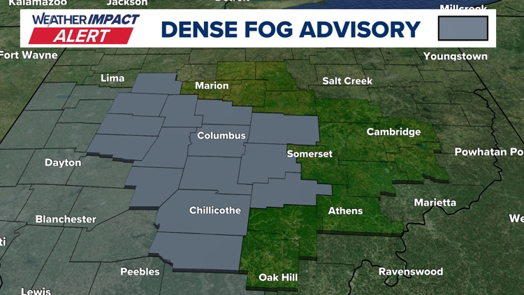
Feb 17, 2026 – Dense fog returns Tuesday, prompting a 10TV Weather Impact Alert and a National Weather Service Dense Fog Advisory; forecasters attribute the fog to cold, moisture‑laden soil meeting warm air, and note a warm storm later in the week will bring near‑record heat and scattered showers[3].
Feb 19‑20, 2026 – A strong storm system moves into central Ohio Thursday night, producing warm, moist air that fuels showers and thunderstorms around 9 p.m.; rainfall exceeds 2 inches by 11:20 p.m., shifting the primary threat to flash flooding in Fayette and Madison counties, while a marginal level‑1 severe‑weather risk leaves an isolated tornado possible[1][2].
Dive deeper (11 sub-stories)
-
Central Ohio Faces Thursday Night Storm, Flood Threat and Lingering Winds
(13 articles)
-
Columbus Hits Record –9°F as Snowpack Deepens, Cold Wave Extends Through Weekend
(3 articles)
-
Central Ohio Schools Set to Reopen Monday After Record Snowstorm and Arctic Freeze
(17 articles)
-
WBNS (Columbus, OH): Central Ohio Schools Remain Closed as Winter Storm Extends to Fifth Day
-
Columbus Zoo Extends Shutdown to Feb. 1 After Record Snowstorm
(3 articles)
-
Ohio Winter Storm Dumps Up to 20 Inches, Triggers County Emergencies and School Closures
(9 articles)
-
WBNS (Columbus, OH): Central Ohio Towing Services Overwhelmed After Heavy Snowfall
-
WBNS (Columbus, OH): Columbus Blue Jackets game postponed to March 9 after heavy snowstorm
-
Ohio Endures Record Snowfall as Winter Storm Persists Through Monday
(2 articles)
-
Kroger and Giant Eagle Shut Hundreds of Ohio Stores Early as Snowstorm Deepens
(2 articles)
-
Warm Christmas Week Forecast Brings Near‑60°F Temperatures and Mild Conditions
(2 articles)
All related articles (54 articles)
-
WBNS (Columbus, OH): Strong Storm System Brings Severe Weather and Flood Risk to Central Ohio
-
WBNS (Columbus, OH): Strong Storm System Moves Through Central Ohio Thursday Night
-
WBNS (Columbus, OH): Dense Fog Advisory Triggers Weather Impact Alert for Central Ohio Tuesday
-
WBNS (Columbus, OH): Snow Returns to Central Ohio as Bitter Cold Lingers, Forecast Calls for Gradual Warm‑up
-
WBNS (Columbus, OH): Columbus Endures Record Cold as Snowpack Persists, Warmer Weather Expected Next Week
-
WBNS (Columbus, OH): Columbus Record Low and Snowpack Keep Central Ohio in Deep Freeze
-
WBNS (Columbus, OH): Columbus Sets New Record Low Temperature of –9°F
-
WBNS (Columbus, OH): Central Ohio Schools Set to Reopen After Snow‑Related Week‑Long Closures
-
WBNS (Columbus, OH): Central Ohio Schools Remain Closed as Winter Storm Extends to Fifth Day
-
WBNS (Columbus, OH): Columbus City Schools Cancel Classes Friday Amid Ongoing Winter Storm and Extreme Cold
-
WBNS (Columbus, OH): Central Ohio Schools Shut Down Friday Amid Arctic Cold
-
WBNS (Columbus, OH): Columbus Zoo Remains Closed Through Feb. 1 Amid Record Snow and Subzero Cold
-
WBNS (Columbus, OH): Central Ohio School Districts Cancel Thursday Classes Amid Arctic Cold
-
WBNS (Columbus, OH): Central Ohio School Districts Close Wednesday Amid Deep Freeze
-
WBNS (Columbus, OH): Ohio Winter Storm Leaves Over 16 Inches of Snow and Triggers Snow Emergencies
-
WBNS (Columbus, OH): Central Ohio Receives Up to 20 Inches of Snow as Major Winter Storm Ends
-
WBNS (Columbus, OH): Central Ohio Towing Services Overwhelmed After Heavy Snowfall
-
WBNS (Columbus, OH): Central Ohio Business and School Closures After Record Snowstorm
-
WBNS (Columbus, OH): Central Ohio School Districts Close Tuesday Amid Heavy Snow and Arctic Cold
-
WBNS (Columbus, OH): Columbus Blue Jackets game postponed to March 9 after heavy snowstorm
-
WBNS (Columbus, OH): Central Ohio schools close Monday as historic snowstorm brings extreme cold
-
WBNS (Columbus, OH): 10TV Extends Live Winter Storm Coverage Across Ohio
-
WBNS (Columbus, OH): Kroger and Giant Eagle close stores early Sunday as Ohio winter storm intensifies
-
WBNS (Columbus, OH): Ohio State cancels in‑person classes Monday‑Tuesday as winter storm hits central Ohio
-
WBNS (Columbus, OH): Giant Eagle Closes All Ohio Stores Early Amid Snowstorm
-
WBNS (Columbus, OH): Ohio Snowstorm Forces Road Closures and Massive Plow Deployment
-
WBNS (Columbus, OH): Cars stuck on I‑70 West as snow intensifies, highways reopen
-
WBNS (Columbus, OH): Columbus Mayor Updates Residents Ahead of Major Winter Storm
-
WBNS (Columbus, OH): DeWine and state officials urge caution as winter storm looms over central Ohio
-
WBNS (Columbus, OH): Central Ohio braces for weekend snow and subzero wind chills as arctic blast returns
-
WBNS (Columbus, OH): Central Ohio schools cancel or delay Tuesday classes amid extreme cold
-
WBNS (Columbus, OH): Columbus Metropolitan Library opens main branch Monday as cold shelter
-
WBNS (Columbus, OH): Columbus Zoo closes Monday amid freezing temperatures
-
WBNS (Columbus, OH): Snow showers expected in central Ohio overnight into Sunday as cold air moves in
-
WBNS (Columbus, OH): Central Ohio braces for up to 2 inches of snow as Weather Impact Alert Day is issued
-
WBNS (Columbus, OH): Snow expected this evening across central and southern Ohio with 1-3 inches of accumulation
-
WBNS (Columbus, OH): Central Ohio braces for 40-50 mph wind gusts Monday as a strong low pressure system moves through
-
WBNS (Columbus, OH): Storm system may bring thunderstorms to central Ohio overnight
-
WBNS (Columbus, OH): Winter season begins with solstice as Columbus forecasts mild Christmas week
-
WBNS (Columbus, OH): Columbus Christmas Day could reach 60 F, entering top-10 warmest records
-
WBNS (Columbus, OH): Central Ohio schools closed or delayed amid winter weather
-
WBNS (Columbus, OH): Central Ohio school closings: Several districts cancel or delay Monday classes due to winter weather
-
WBNS (Columbus, OH): Columbus City Schools cancels classes, extracurriculars Monday due to inclement weather
-
WBNS (Columbus, OH): Sub-zero wind chills Sunday & Monday after heavy snow Saturday
-
WBNS (Columbus, OH): Winter storm brings several inches of snow to central Ohio: Current snowfall totals
-
WBNS (Columbus, OH): Columbus City Schools cancels some extracurriculars Saturday due to winter weather
-
WBNS (Columbus, OH): Rain, snow and wind impacting Wednesday morning commute in central Ohio
-
WBNS (Columbus, OH): Ohio Experiences Record Low Wind Chills on Friday Morning
-
WBNS (Columbus, OH): Central Ohio Faces Single‑Digit Wind Chill Friday Morning
-
WBNS (Columbus, OH): Columbus, Ohio Receives 3‑6 Inches of Snow After Winter Storm
-
WBNS (Columbus, OH): Central Ohio Receives Up to 5 inches of Snow Tuesday Morning
-
WBNS (Columbus, OH): Franklin County Courts Closed Tuesday Due to Winter Weather
-
WBNS (Columbus, OH): Central Ohio Schools and Courts Cancel Classes and Close on Tuesday Due to Snow
-
WBNS (Columbus, OH): Columbus City Schools Cancel Tuesday Classes Amid Overnight Snow
External resources (24 links)
- https://warriorwatch.columbus.gov/ (cited 2 times)
- http://emergency.osu.edu (cited 1 times)
- http://facebook.com/AaronWhiteTV/ (cited 4 times)
- http://instagram.com/aaronwhitetv/ (cited 4 times)
- http://x.com/AaronWhiteTV (cited 4 times)
- https://twitter.com/hashtag/ODOTwinter?src=hash&ref_src=twsrc%5Etfw (cited 3 times)
- https://www.facebook.com/AaronWhiteTV (cited 2 times)
- https://www.facebook.com/ChrisTomer (cited 2 times)
- https://www.facebook.com/GarofaloWX (cited 2 times)
- https://www.facebook.com/mikebehrenswx (cited 2 times)
- https://t.co/D3AfQbTt0n (cited 1 times)
- https://t.co/kZTfz0pmJJ (cited 1 times)
- https://t.co/y2mdfitzGi (cited 1 times)
- https://t.co/zE47OTcGJ2 (cited 1 times)
- https://www.facebook.com/ColumbusCitySchools (cited 1 times)
- https://www.facebook.com/ohiodrc/posts/pfbid0eQwq1EC4PRv1zc6YYTEmCVgTZEWanfusM6nZS1LEJBYcNYKc6utcpBPJUZK6TCHpl (cited 1 times)
- https://www.facebook.com/photo/?fbid=1539829818143817&set=a.542568367869972 (cited 1 times)
- https://www.facebook.com/share/p/17aHwhEg5Q/ (cited 1 times)
- https://www.facebook.com/share/p/17vsgKJoM9/ (cited 1 times)
- https://www.facebook.com/share/p/188JhExC1c/ (cited 1 times)
- https://portal.snowpaths.com/public/983278/983279 (cited 2 times)
- https://provolleyball.com/news/2026/01/atlanta-at-columbus-mlv-match-postponed (cited 1 times)
- https://snowgo.dublin.oh.us/ (cited 1 times)
- https://tv.10tv.com/ (cited 1 times)