Columbus Hits Record –9°F, Snowpack Over 16 Inches, Cold to Last Until Next Week
Updated (2 articles)
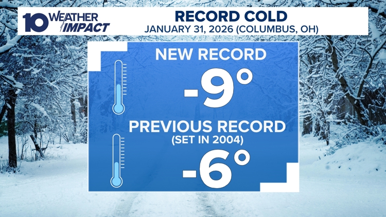
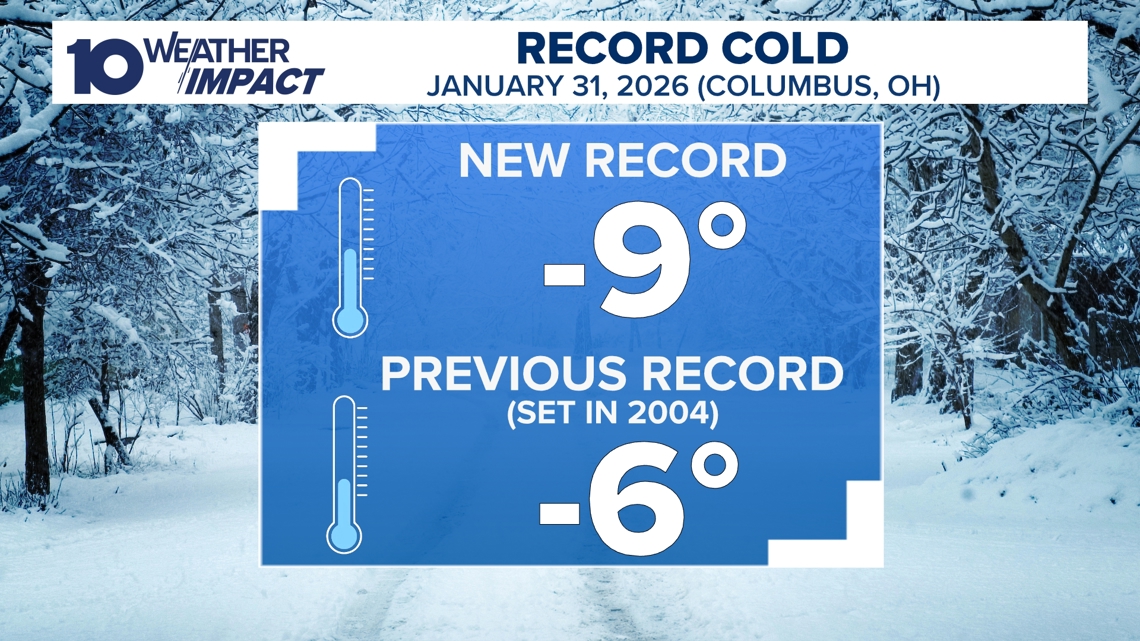
Record‑breaking temperature shatters previous low On Saturday morning, Feb. 1, 2026, Columbus recorded a new all‑time low of –9°F, surpassing the former –6°F record [1][2]. The frigid reading occurred as an arctic air mass descended from Canada, driving temperatures into the low single digits across central Ohio. Meteorologists warned that wind chills fell even lower, prompting immediate public safety alerts.
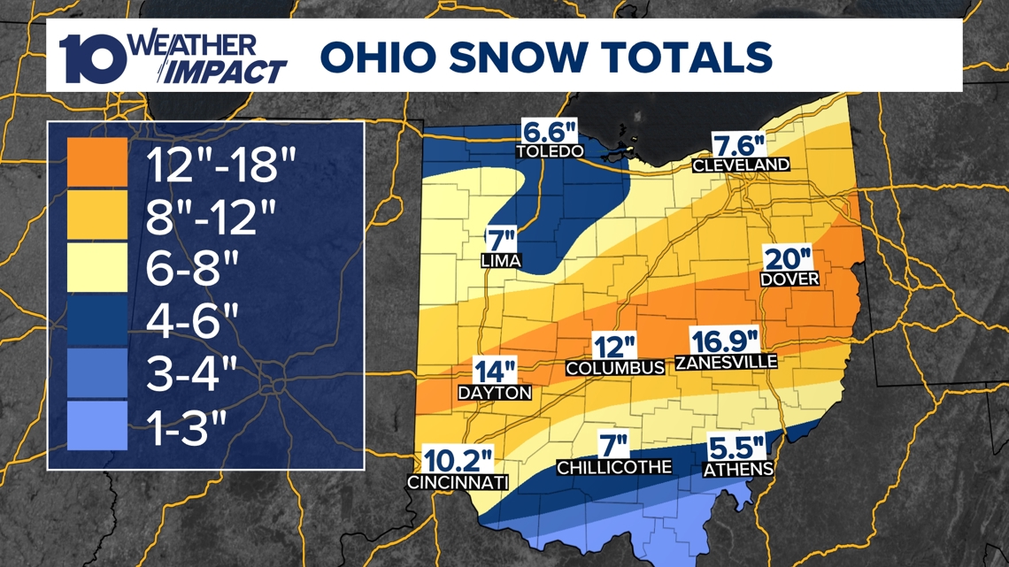
Snowpack deepens across the state, reaching up to 16 inches Statewide snow cover persisted throughout the weekend, with central Ohio reporting accumulations ranging from eight to more than sixteen inches [1][2]. The extensive snowpack reinforces the cold air, limiting any rapid temperature recovery. Snow‑report data show the entire state blanketed in snow, a condition expected to continue through Sunday.
10 Weather Impact Alert Day extended through Sunday The alert, originally issued for hazardous conditions, was prolonged until Sunday morning because wind chills plunged further into dangerous territory [1][2]. Residents were urged to limit travel, protect exposed pipes, and keep heating systems operational. The extended alert underscores the severity of the deep freeze and the risk of frostbite and hypothermia.
Forecast predicts sub‑20°F temperatures until next week Meteorologists project that the Canadian arctic air will keep temperatures below the 20s for the remainder of the weekend, delaying any warming until the following week [1][2]. Models indicate a gradual rise into the 20s and 30s only after the cold core moves eastward. This outlook informs emergency planners and utility companies preparing for prolonged heating demand.
10TV+ streaming provides continuous weather updates The 10 Weather Impact team offers live forecasts and alerts via the free 10TV+ app on Roku and Amazon Fire TV, ensuring residents can access real‑time information [1][2]. The platform streams 24/7 coverage, including detailed snow‑accumulation maps and safety advisories. Free on‑demand content helps the public stay informed despite the ongoing severe weather.
Sources
-
1.
WBNS: Columbus Endures Record Cold as Snowpack Persists, Warmer Weather Expected Next Week – Highlights the –9°F record, 8‑16+ inch snow depths, and forecasts a warming trend only after the weekend .
-
2.
WBNS: Columbus Record Low and Snowpack Keep Central Ohio in Deep Freeze – Emphasizes the record low, extended alert day, statewide snow cover, and the expectation that temperatures stay below the 20s until next week .
Timeline
Prior to 2026 – Columbus’s all‑time low stands at –6°F, the benchmark that the 2026 cold snap later shatters, illustrating the severity of the upcoming freeze [1][2].
Jan 24, 2026 – Columbus plunges to a record low of –9°F, breaking the previous –6°F record as arctic air from Canada settles over central Ohio, marking the coldest temperature ever recorded in the city [1][2].
Jan 24, 2026 – Snow accumulates 8‑16+ inches across central Ohio, blanketing the entire state and creating a deep snowpack that locks in the cold and delays any warming [1][2].
Jan 24‑25, 2026 – The 10 Weather Impact Alert Day extends through Sunday morning as wind chills plunge into the low single digits, prompting hazardous‑condition warnings for residents [1][2].
Jan 24‑25, 2026 – Meteorologists say the Canadian arctic air mass will keep temperatures below 20°F throughout the weekend, preventing any rise into the 20s or 30s until the following week [1][2].
Jan 24‑25, 2026 – The 10 Weather Impact team provides continuous updates via the free 10TV+ streaming service on Roku and Amazon Fire TV, ensuring the public can monitor the evolving freeze 24/7 [1][2].
Early Feb 2026 (next week) – Forecasts project a gradual warm‑up, with temperatures expected to climb into the 20s and possibly the 30s, ending the deep freeze that has persisted since the weekend [1][2].