Lowland Snow Showers Lower Levels to 500‑1000 ft Amid Mixed Forecast
Updated (19 articles)
Lowland Snow Showers Push Snow Levels to Historic Lows Brief bursts of snow on Wednesday evening dropped snow levels to 500‑1,000 ft across Snohomish, King and Pierce counties, with Bothell (≈300 ft) and Maltby (≈400 ft) receiving measurable snow due to a weak convergence zone; accumulations remained light, leaving roads slushy rather than snow‑covered, and the Granite Falls School District closed schools for the day [2].
Mid‑Week Forecast Calls for Mixed Rain‑Snow and Sunbreaks Thursday will see intermittent rain or wet‑snow showers mixed with sunbreaks, lows in the low‑mid 30s and highs in the mid‑40s, while snow levels climb from 300‑500 ft in the morning to 500‑700 ft by afternoon; Friday turns partly sunny and cool with lows in the upper 20s‑mid 30s and highs in the low‑mid 40s [1].
Weekend Systems Raise Snow Levels While Maintaining Showers Saturday brings a few showers, clearing periods, and a snow level near 1,500 ft with highs in the mid‑upper 40s; Sunday repeats the pattern with snow levels around 2,000 ft, and early next week (Monday‑Tuesday) will feature intermittent rain and snow levels near 2,500 ft, while outflow winds from the Fraser River drive wind chills into the teens‑low 20s across western Whatcom County [1].
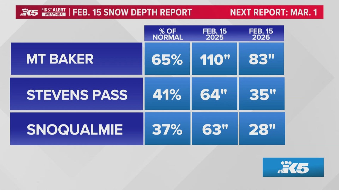
Statewide Snowpack Lags at 65% of Normal, Threatening Summer Water As of mid‑February, the Cascades hold roughly two‑thirds of average snow, but elevations between 3,000‑5,000 ft are only at 40% of typical depth; Snoqualmie Pass shows the greatest deficit, whereas Paradise on Mt Rainier and Mt Baker remain closer to normal, raising concerns for summer water storage in the Columbia Basin [3].
Models Predict Additional Snow but Winds Limit Accumulation Computer models forecast more snowfall later this week, yet prevailing winds parallel the Cascades, reducing storm capture; historically peak snow depth occurs in early April, leaving only 6‑8 weeks for buildup, and a weak La Niña shifting toward neutral suggests a 50‑60% chance of a weak El Niña next winter [3].
Sources
-
1.
King5:Western Washington Weather Outlook Through Early Next Week: Provides detailed day‑by‑day forecast, highlighting mixed rain‑snow Thursday, partly sunny Friday, rising snow levels through the weekend and early next week, plus strong Fraser River winds causing low wind chills .
-
2.
King5:Brief Lowland Snow Showers Lower Snow Levels in Snohomish County: Reports Wednesday lowland snow dropping levels to 500‑1,000 ft, minimal accumulations, school district closure, and the convergence‑zone snow in Bothell and Maltby .
-
3.
King5:Washington Snowpack Lags Normal, Raising Summer Water Concerns: Details statewide snowpack at ~65% of normal, severe deficit at Snoqualmie Pass, and implications for water resources and fire risk .
-
4.
King5:Lowland Snow Possible Wednesday as Western Washington Precipitation Increases: Forecasts snow levels near 500 ft Wednesday, mixed rain‑snow across Kitsap and coastal foothills, and a rise to ~1,500 ft by Saturday, limiting lowland impacts .
Related Tickers
Timeline
Nov 28, 2025 – A ridge of high pressure over the Gulf of Alaska creates a dry pattern for the Thanksgiving weekend, with partly sunny Friday, mostly dry Saturday, and a chance of light showers Sunday; snow levels sit near 4,000‑5,000 ft and the next precipitation chance arrives late Monday‑Tuesday [19].
Dec 17, 2025 – Winds ease over Snoqualmie Pass and western Washington, a cooler pattern settles, and forecasts call for 5‑10 inches of snow at the passes Wednesday‑Thursday while an atmospheric river brushes the region Thursday with half‑inch rain in lowlands and 1‑2 inches in the mountains [18].
Dec 20, 2025 – Heavy mountain snow returns ahead of Christmas, delivering more than 18 inches at Stevens Pass and about 10 inches at Snoqualmie Pass; officials warn travel could become hazardous Sunday night and cumulative totals may reach 1 ft at lower passes and 2‑3 ft at Mount Baker by early Tuesday [16].
Dec 27, 2025 – Light snow lingers in a Puget Sound convergence zone into Saturday morning, dropping up to 2 inches in Snohomish and King counties while mountain passes collect 10‑14 inches; a ridge then holds dry, cold nights through Monday before a new system approaches late Wednesday‑Thursday [14].
Dec 27, 2025 – A Winter Weather Advisory warns that snow levels will drop to ~2,500 ft Friday, bringing 6‑12 inches of snow across the Cascades and potentially dangerous travel on I‑90 over Snoqualmie Pass; officials urge travelers to carry emergency kits and check conditions before Saturday trips [15].
Dec 31, 2025 – Jan 1, 2026 – High pressure keeps New Year’s Eve dry across western Washington, allowing celebrations without rain; a weak system brings low‑land rain and light mountain snow on New Year’s Day, and forecasters anticipate a stronger system Saturday‑Sunday that could produce steadier rain and moderate‑to‑heavy mountain snowfall [13].
Jan 8, 2026 – A colder system moves through western Washington, dropping snow levels to about 1,500 ft during the day and as low as 500 ft overnight, producing spotty low‑land wet snow and a Winter Storm Warning that could add 2‑4 ft of snow to the Cascades while lowland accumulation remains minimal [12].
Jan 9, 2026 – The western U.S. experiences a snow drought as a persistent ridge blocks storms, leaving Utah’s backcountry snowmobiling tours canceled, Arizona records its hottest December, and officials warn that the 2034 Salt Lake City Winter Olympics could face recurring weak snowpacks [1].
Jan 15, 2026 – A high‑pressure ridge extends a dry spell across western Washington through the weekend, producing record‑tying January warmth (Sea‑Tac 58 °F) and keeping snow levels near 12,000 ft; the next meaningful rain is not expected until late next week [11].
Jan 24, 2026 – A Cold Weather Advisory holds overnight, with Seattle‑metro temperatures plunging to 20‑25 °F and a risk of hypothermia; despite the cold, the weekend remains bright and dry, and Sea‑Tac records its 11th consecutive rain‑free day [10].
Jan 27, 2026 – Seattle’s 14‑day rainless streak nears the 1963 record; light showers arrive Tuesday night, snow levels drop to ~4,000 ft Wednesday allowing a few inches of snow at high elevations, then rise to 5,000‑6,000 ft by week’s end, limiting further snowpack recovery [9].
Jan 29, 2026 – The Cascade Mountains retain only a fraction of normal snowpack despite recent snowfall (2‑4 inches at key passes); Oregon’s snowpack ranks second‑lowest since 1981, and the deficit threatens spring streamflow across Washington [8].
Feb 4, 2026 – Skiers at Snoqualmie Pass describe “spring‑like” conditions with slushy surfaces and exposed rocks as regional snowpack falls below 50 % of normal; Climate Central’s Shel Winkley calls it the worst snow drought on record, raising concerns for water supplies and an extended fire season [7].
Feb 17, 2026 – Forecasts call for low‑elevation snow Wednesday as snow levels hover between 500‑1,000 ft, with a rain‑snow mix across the Kitsap Peninsula and mountains expected to add 6‑12 inches of snow by week’s end; snow levels then rise to ~1,500 ft by Saturday, reducing lowland snow chances [6].
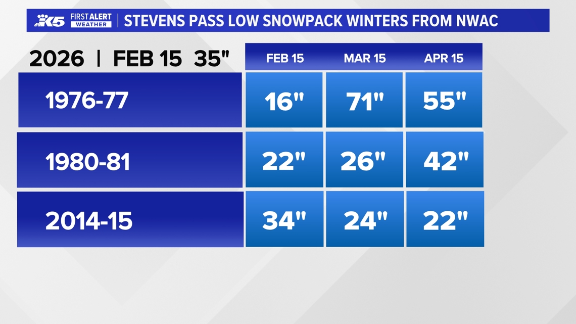
Feb 18, 2026 – Washington’s statewide snowpack sits at roughly 65 % of normal, with Snoqualmie Pass at only 40 % of typical depth; models predict more snow but prevailing winds limit capture, and a weak La Niña shifts toward neutral, giving a 50‑60 % chance of a weak El Niño next winter—historically linked to low‑snow winters in 1976‑77, 1980‑81, and 2014‑15 [5].
Feb 19, 2026 – Brief low‑land snow showers affect Snohomish, King, and Pierce counties Wednesday evening, dropping snow levels to 500‑1,000 ft and prompting a one‑day closure of the Granite Falls School District; accumulations remain minimal and roads stay slushy [3].
Feb 19, 2026 – The Western Washington weather outlook predicts mixed rain and wet‑snow showers Thursday, cool partly sunny Friday, and rising snow levels through the weekend (up to 2,500 ft by early next week), with outflow winds from the Fraser River driving wind chills into the teens‑low 20s in Whatcom County [4].
Dive deeper (6 sub-stories)
-
King5 (Seattle, WA): Brief Lowland Snow Showers Lower Snow Levels in Snohomish County
-
Washington Snowpack at 65% of Normal Threatens Summer Water Supply
(8 articles)
-
King5 (Seattle, WA): Spring‑like Ski Conditions Hit Snoqualmie Pass as Snowpack Plummets
-
Puget Sound Warm Midweek Turns to Rain and Snow on Weekend
(5 articles)
-
King5 (Seattle, WA): Cold Weather Advisory Extends Into Saturday Morning for Seattle Metro
-
Western U.S. Snow Drought Deepens, Threatening Tourism, Water Supplies, 2034 Olympics
(3 articles)
All related articles (19 articles)
-
King5 (Seattle, WA): Western Washington Weather Outlook Through Early Next Week
-
King5 (Seattle, WA): Brief Lowland Snow Showers Lower Snow Levels in Snohomish County
-
King5 (Seattle, WA): Washington Snowpack Lags Normal, Raising Summer Water Concerns
-
King5 (Seattle, WA): Lowland Snow Possible Wednesday as Western Washington Precipitation Increases
-
King5 (Seattle, WA): Spring‑like Ski Conditions Hit Snoqualmie Pass as Snowpack Plummets
-
King5 (Seattle, WA): Cascade Mountains Snowpack Lags Behind Recent Snowfall
-
King5 (Seattle, WA): Seattle’s 14‑Day Dry Spell Nears Record as Rain Returns Tuesday
-
King5 (Seattle, WA): Cold Weather Advisory Extends Into Saturday Morning for Seattle Metro
-
King5 (Seattle, WA): Extended dry weather persists across western Washington through weekend
-
CNN: The western US is in a snow drought, raising fears for summer water supplies
-
King5 (Seattle, WA): Snow levels fall overnight across western Washington, raising chance of lowland wet snow and slick roads
-
King5 (Seattle, WA): Dry New Year’s Eve ends rain; showers expected on New Year’s Day in Western Washington
-
King5 (Seattle, WA): Western Washington sees light snow, then dry stretch with freezing nights ahead
-
King5 (Seattle, WA): Snow could complicate post-Christmas mountain pass travel in Washington
-
King5 (Seattle, WA): Heavy mountain snow continues toward Christmas across Cascades, with up to 2–3 feet possible at some passes
-
King5 (Seattle, WA): Warm weather and low snowpack disrupt Western ski resorts
-
AP: Warm weather and low snowpack slow Western ski resorts
-
King5 (Seattle, WA): Blustery weather eases in western Washington
-
King5 (Seattle, WA): Dry Weather Expected Over Holiday Weekend, With Spotty Showers Possible
External resources (13 links)
- https://nwcc-apps.sc.egov.usda.gov/imap/#version=2&elements=&networks=!&states=!&basins=!&hucs=&minElevation=&maxElevation=&elementSelectType=any&activeOnly=true&activeForecastPointsOnly=true&hucLabels=false&hucIdLabels=false&hucParameterLabels=true&stationLabels=&overlays=&hucOverlays=state&basinOpacity=100&basinNoDataOpacity=100&basemapOpacity=100&maskOpacity=0&mode=data&openSections=dataElement,parameter,date,basin,options,elements,location,networks,baseMaps,overlays,labels&controlsOpen=true&popup=&popupMulti=&popupBasin=&base=esriWgc&displayType=basin&basinType=6&dataElement=SNWD&depth=-8¶meter=PCTPORMED&frequency=MONTHLY&duration=I&customDuration=&dayPart=E&monthPart=E&forecastPubDay=1&forecastExceedance=50&useMixedPast=true&seqColor=2&divColor=7&scaleType=D&scaleMin=&scaleMax=&referencePeriodType=POR&referenceBegin=1991&referenceEnd=2020&minimumYears=20&hucAssociations=true&relativeDate=-1&lat=41.305&lon=-112.429&zoom=5.5 (cited 2 times)
- https://forecast.weather.gov/wwamap/wwatxtget.php?cwa=SEW&wwa=winter%2520weather%2520advisory (cited 1 times)
- https://nwcc-apps.sc.egov.usda.gov/imap/#version=169&elements=&networks=!MSNT&states=!&basins=!&hucs=&minElevation=&maxElevation=&elementSelectType=any&activeOnly=true&activeForecastPointsOnly=false&hucLabels=true&hucIdLabels=false&hucParameterLabels=true&stationLabels=&overlays=&hucOverlays=state&basinOpacity=75&basinNoDataOpacity=0&basemapOpacity=100&maskOpacity=100&mode=data&openSections=dataElement,parameter,date,basin,options,elements,location,networks,baseMaps,overlays,labels&controlsOpen=true&popup=&popupMulti=&popupBasin=&base=esriWsr&displayType=basin&basinType=wa_8&dataElement=WTEQ&depth=-8¶meter=PCTMED&frequency=DAILY&duration=I&customDuration=&dayPart=E&monthPart=B&forecastPubDay=1&forecastExceedance=50&useMixedPast=true&seqColor=1&divColor=7&scaleType=D&scaleMin=&scaleMax=&referencePeriodType=fixed&referenceBegin=1991&referenceEnd=2020&minimumYears=20&hucAssociations=true&relativeDate=-1&lat=48.124&lon=-120.914&zoom=6.9&autoExport=full,pdf,2,2,L,BL,Washington%2520SNOTEL,49.4893,44.9175,-114.8615,-125.2705 (cited 1 times)
- https://wsdot.com/travel/real-time/mountainpasses/Blewett (cited 1 times)
- https://wsdot.com/travel/real-time/mountainpasses/Cayuse (cited 1 times)
- https://wsdot.com/travel/real-time/mountainpasses/Chinook (cited 1 times)
- https://wsdot.com/travel/real-time/mountainpasses/Crystal-to-Greenwater (cited 1 times)
- https://wsdot.com/travel/real-time/mountainpasses/Mt.-Baker (cited 1 times)
- https://wsdot.com/travel/real-time/mountainpasses/North-Cascade-Hwy (cited 1 times)
- https://wsdot.com/travel/real-time/mountainpasses/Snoqualmie (cited 1 times)
- https://wsdot.com/travel/real-time/mountainpasses/Stevens (cited 1 times)
- https://wsdot.com/travel/real-time/mountainpasses/White (cited 1 times)
- https://www.weather.gov/sew/ (cited 1 times)