High‑Pressure Ridge Brings Nationwide Warmth While Northeast Stays Bitterly Cold
Updated (3 articles)
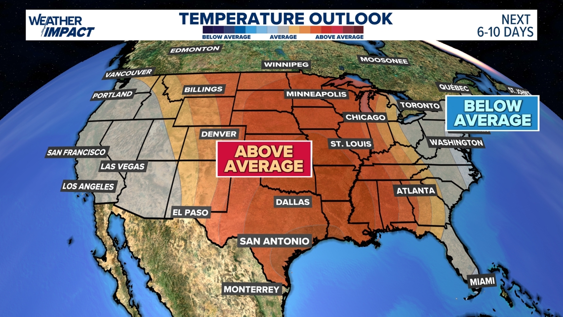
Ridge Development Shifts Temperatures Nationwide A strengthening high‑pressure ridge is building over the United States, allowing milder air to replace the Arctic cold that dominated January. This marks the first widespread return to above‑average temperatures in several weeks, offering a noticeable break from harsh winter conditions across most of the country[1].
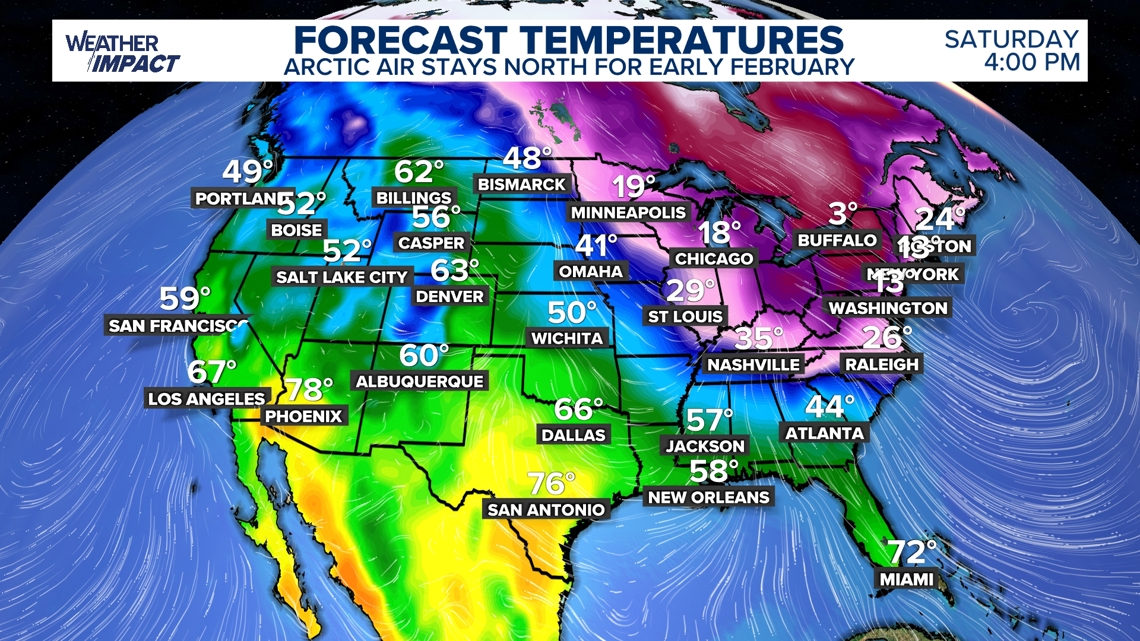
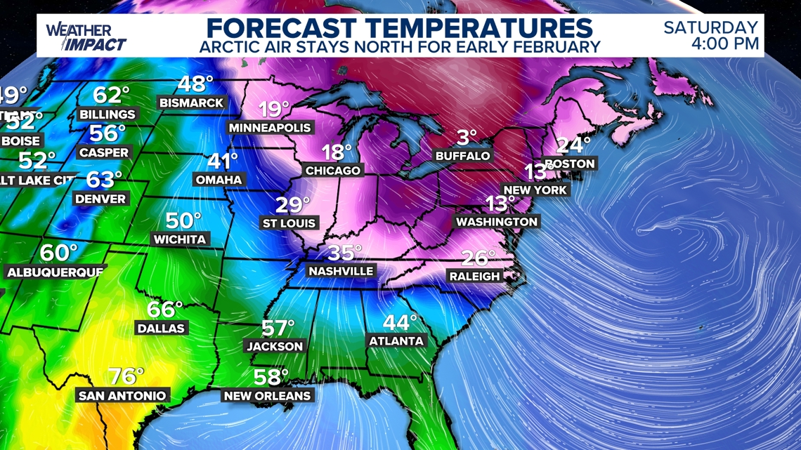
Northeast Remains Cold Amid General Warmth Forecasts for Saturday afternoon show the Northeast staying in single‑digit temperatures with wind chills even colder into the second week of February. A deepening trough moving slowly eastward keeps arctic air clipped over the Midwest and New England, creating persistent cold pockets despite the broader warming trend[1].
Mid‑February Forecast Shows Significant Above‑Average Highs As February progresses, highs are expected to run 10‑20 °F above seasonal norms for large portions of the central and eastern United States. This warmer pattern follows consecutive days of freezing temperatures that defined much of January, signaling a shift toward a milder mid‑month climate[1].
Warm Spell Provides Relief to Storm‑Hit Communities The temporary milder conditions give a pause for regions still recovering from recent snow and ice storms that strained infrastructure, disrupted travel, and increased heating demands nationwide. While winter is not over, the warming offers a welcome contrast for affected communities[1].
Arctic Air Persistence Due to Slow‑Moving Trough The deepening trough that helps dislodge arctic air will be slow to move east and out of the U.S., causing arctic air to linger in the Northeast and Midwest for early February before the ridge fully dominates. This explains the continued cold pockets despite overall warming across most of the country[1].
Timeline
Since 1970 – Yearly minimum temperatures in major U.S. cities such as Minneapolis and Cleveland rise steadily, showing that overall winters are warming even as occasional severe cold snaps occur [1].
2025‑2026 winter – The Western United States records its warmest winter on record, leaving Colorado ski resorts and other mountain areas starved for snow while the East endures historic cold [1].
Jan 22, 2026 – A stretched polar vortex drives Arctic air deep into the Central and Eastern U.S.; MIT researcher Judah Cohen links the vortex‑stretching to reduced sea‑ice in the Barents and Kara Seas, warning that “the loss of Arctic sea ice may be loading the dice for extreme winter weather” [1]; Woodwell Climate Research Center’s Jennifer Francis cautions that a single event cannot be blamed on climate change, even as warming coexists with severe cold [1].
Jan 23, 2026 – A low‑pressure system forms over the southern Plains and Rockies, beginning the expansive winter storm that will later blanket nearly half the nation [2].
Jan 24, 2026 – NASA satellites capture the storm’s massive cloud shield as it spreads from Texas to New England, prompting more than a dozen states and D.C. to declare emergencies and placing roughly 140 million people under winter‑storm alerts; the National Weather Service issues travel advisories, and airlines cancel over 8,000 flights while rail networks report widespread delays [2].
Feb 4, 2026 – A strengthening high‑pressure ridge pushes milder air across most of the United States, delivering mid‑February highs 10‑20 °F above average and offering a brief reprieve for communities still recovering from snow and ice damage; however, a lingering trough keeps the Northeast and parts of the Midwest in single‑digit temperatures with wind chills well below freezing [3].
All related articles (3 articles)
External resources (2 links)
- https://frigid temperatures, massive snow and deadly ice storm (cited 1 times)
- https://www.climatecentral.org/climate-matters/coldest-days-warming-up (cited 1 times)