Snow Returns to Central Ohio With Advisory, Two More Systems Expected This Week
Updated (2 articles)
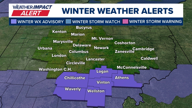
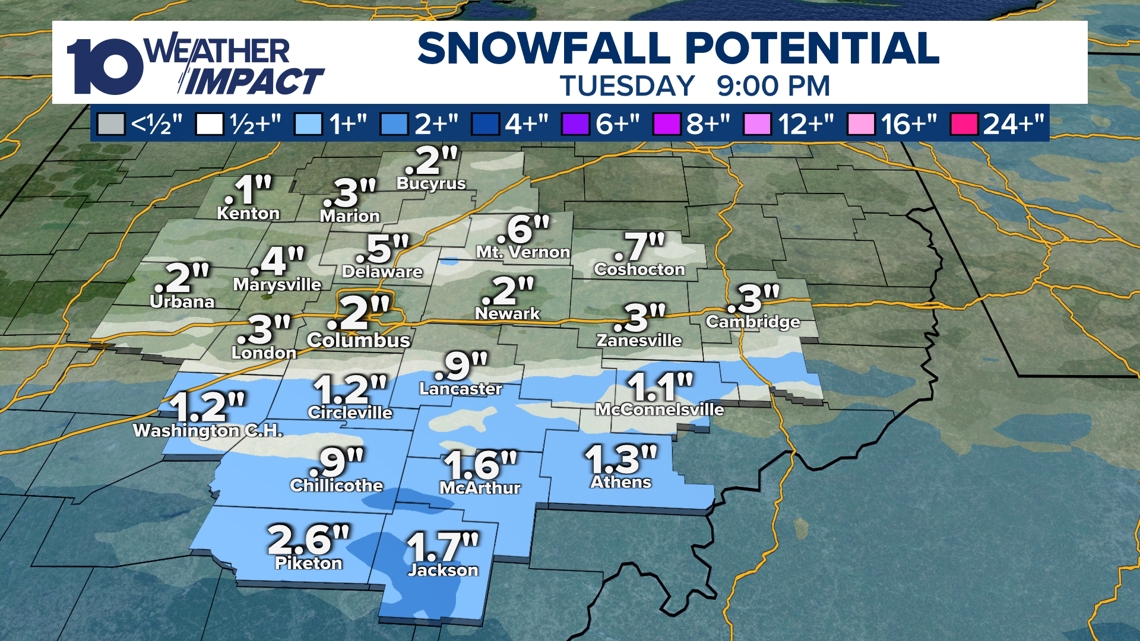
Tuesday Snow Band Triggers Advisory Across Southern Ohio Flurries moved through central Ohio on Monday, and a narrow band of light‑to‑moderate snow is forecast for areas near and south of Interstate 70 late Tuesday morning into the afternoon, prompting a Winter Weather Advisory for Chillicothe, Piketon, Jackson and Athens with expected accumulations of 1‑3 inches [1].
Midweek Temperatures Drop Into the 20s After the Tuesday snowfall clears, high temperatures are projected to fall into the 20 °F range on Wednesday and Thursday as a cold air mass follows the first system [1].
Friday System Brings Broader Light Snow A second system on Friday is expected to produce a wider but lighter snow event across central Ohio, with most locations seeing only a dusting or up to two inches of accumulation, offering a more widespread impact than Tuesday’s narrow band [1].
Weekend Brings Subzero Wind Chills After Snow As Friday’s snow clears, an even colder air mass will move in for Saturday and Sunday, generating subzero wind‑chill values during the morning hours and prompting additional advisories for residents [1].
Early Next Week Forecasts Temperatures Above Freezing Computer models indicate a warming trend early the following week, with possible daytime highs reaching the 40 °F range by the end of that week, providing a brief reprieve from the subfreezing conditions [1].
Timeline
Dec 2, 2025 – Central Ohio receives 3‑5 inches of snow, with Worthington exceeding 6 inches, causing travel disruptions and school cancellations as forecasters note the heavy accumulation across the region [2].
Dec 2‑3, 2025 – Overnight road conditions deteriorate as snow and ice make highways slippery, prompting commuter cautions and contributing to school closures in the affected counties [2].
Dec 3, 2025 – Winter Weather Advisories are lifted after the snow system exits Ohio, allowing local authorities to resume normal operations [2].
Dec 2025 (second half of week) – Temperatures remain at or below freezing, with spotty flurries expected, signaling a continued cold snap across the Ohio Valley [2].
Dec 2025 (late week) – Forecasters identify another system tracking toward the Ohio Valley, though detailed predictions remain unavailable, indicating potential additional snowfall later in the month [2].
Feb 2, 2026 – Flurries and snow showers move through central Ohio on Monday, prompting the 10 Weather Impact team to issue a Winter Weather Advisory for southern Ohio cities and forecast 1‑3 inches of accumulation [1].
Feb 2, 2026 – The advisory specifically lists Chillicothe, Piketon, Jackson and Athens, where forecasters expect a general 1‑3 inches of snow within a narrow band [1].
Feb 3, 2026 – A first system arrives near and south of Interstate 70, delivering a narrow band of light‑to‑moderate snow late Tuesday morning into the afternoon, marking the start of the week’s snow events [1].
Feb 4‑5, 2026 – Highs dip into the 20 °F range on Wednesday and Thursday as colder air follows the Tuesday system, setting the stage for further snowfall chances later in the week [1].
Feb 7, 2026 – A broader but lighter system moves in on Friday, expected to produce only a dusting to two inches of snow across most of central Ohio, offering a more widespread but modest accumulation [1].
Feb 8‑9, 2026 – Saturday and Sunday bring subzero wind‑chill values during morning hours as a much colder air mass follows the Friday snow, prompting additional advisories for residents [1].
Feb 12, 2026 (early next week) – Computer models project a warming trend with possible highs in the 40 °F range by the end of the week, suggesting a brief reprieve from subfreezing conditions after the cold weekend [1].
All related articles (2 articles)
External resources (3 links)
- https://www.facebook.com/AaronWhiteTV (cited 1 times)
- https://www.instagram.com/aaronwhitetv/ (cited 1 times)
- https://x.com/AaronWhiteTV (cited 1 times)