High‑Pressure Ridge Brings Nationwide Warm Spell While Northeast Remains Frigid
Updated (2 articles)
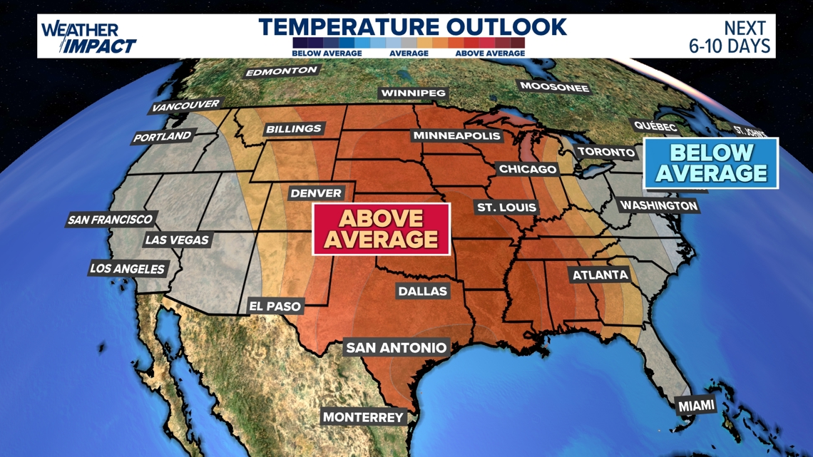
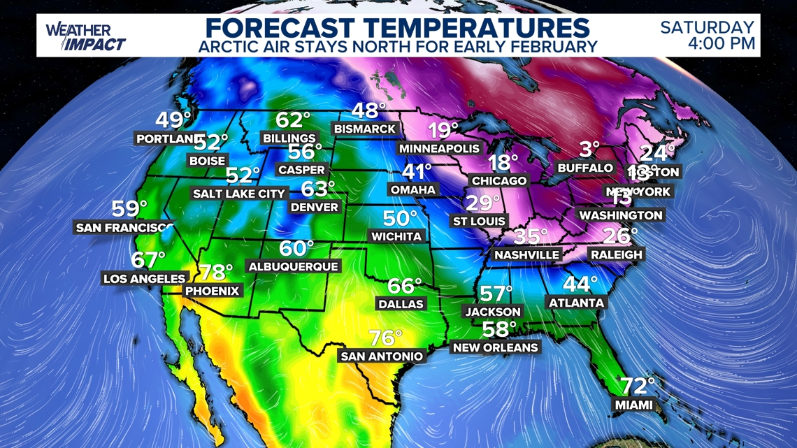
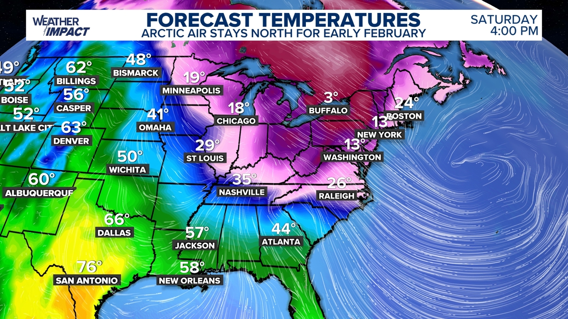
Ridge Development Shifts Temperatures Nationwide The National Weather Service reported that a strengthening high‑pressure ridge began building over the United States on Saturday, February 4, 2026, replacing the Arctic air that dominated January. The ridge is expected to push milder air across most of the country through mid‑February. Forecast models show highs 10‑20 °F above normal for central and eastern regions, providing a noticeable break from the previous weeks of freezing temperatures [1].
Northeast and Midwest Retain Arctic Cold deepening trough in the eastern U.S. continues to channel Arctic air into the Northeast and parts of the Midwest, keeping temperatures in the single digits with wind chills well below zero. The trough moves slowly eastward, so the cold pocket will persist into the second week of February. Residents of New England and the Mid‑Atlantic can expect continued icy conditions despite the warming elsewhere [1].
Warm Spell Relieves Storm‑Impacted Communities Communities still recovering from recent snow and ice storms benefit from the temporary milder weather, as reduced heating demand eases strain on power grids. Road crews report faster clearing of icy surfaces, and travel disruptions lessen across the Midwest and South. Officials note that while winter is not over, the pause allows infrastructure repairs to progress [1].
Forecast Highlights Seasonal Anomaly Meteorologists emphasize that the contrast between the warming ridge and the lingering cold trough creates a rare early‑February temperature gradient. The pattern could set records for above‑average highs in several states, while the Northeast may record one of the coldest February weeks on record. The situation underscores the volatility of the 2026 winter season [1].
Timeline
Since 1970 – Yearly minimum temperatures in major U.S. cities rise, showing that overall winters are warming even as occasional severe cold snaps occur [1].
Winter 2025‑2026 – Western states record their warmest winter on record, leaving ski resorts with scant snow and underscoring the uneven regional impacts of climate change [1].
Late Jan 2026 – A powerful winter storm forms east of the Rockies, set to dump heavy snow and ice across the Central and Eastern U.S.; experts note that such events can still happen in a warming world [1].
Late Jan 2026 – A stretched polar vortex, linked to reduced Arctic sea ice in the Barents and Kara Seas, drives Arctic air deep into the U.S., creating a large dip in the jet stream (Judah Cohen: “The loss of sea ice loads the dice for extreme cold events”) [1].
Late Jan 2026 – Climate scientists caution against blaming the storm on climate change alone, emphasizing that “warmer winters are the global trend, yet the same warming can coexist with severe winter weather” (Jennifer Francis) [1].
Early Feb 2026 – A strengthening high‑pressure ridge builds over the United States, bringing the first widespread above‑average temperatures after weeks of Arctic cold [2].
Early Feb 2026 – A slow‑moving trough keeps the Northeast and parts of the Midwest in single‑digit temperatures with wind chills well below freezing [2].
Mid‑Feb 2026 (forecast) – Highs across the central and eastern U.S. are expected to run 10‑20 °F above seasonal norms, offering a temporary warm spell that eases strain on communities still recovering from recent snow and ice storms [2].
Mid‑Feb 2026 (forecast) – Arctic air is projected to linger in the Northeast until the ridge fully dominates, delaying full warming in that region [2].
All related articles (2 articles)
External resources (2 links)
- https://frigid temperatures, massive snow and deadly ice storm (cited 1 times)
- https://www.climatecentral.org/climate-matters/coldest-days-warming-up (cited 1 times)