Recent Snowfall Fails to Close Cascade Snowpack Deficit, Record Low Persists
Updated (7 articles)
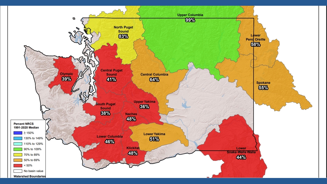
Snowpack Remains Well Below Historic Averages Recent measurements show the Cascade snowpack is far under historic averages, with Washington’s pack ranking as the second‑lowest on record since 1981 [1]. The shortfall is evident across the western United States, confirming a broad regional deficit [1]. These conditions threaten spring water supplies that depend on mountain snow [1].
Modest New Snowfall Insufficient to Offset Shortfall 24‑hour snowfall totals recorded Wednesday were 2‑3 inches at Stevens Pass, 1‑2 inches at Snoqualmie Pass, about 1 inch at Crystal Mountain, and roughly 4 inches on Mount Baker [1]. Such modest accumulations are inadequate to close the existing deficit [1]. The limited snowfall underscores the need for larger precipitation events later in the season [1].
Early‑Season Warmth Converted Precipitation to Rain Warm temperatures and below‑normal precipitation from October through November created an early deficit statewide [1]. A December system delivered significant moisture, but high temperatures caused most of it to fall as rain even at mountain elevations, limiting snow accumulation [1]. This rain‑instead‑of‑snow pattern reduced the potential for early‑season snowpack buildup [1].
SNOTEL Sensors Show Regional Variability in Deficits Sensors in the central and southern Washington Cascades report snow‑water equivalent well below normal [1]. In contrast, stations in the Methow Basin and parts of the Upper Columbia and Skagit River basins are at or above normal levels [1]. The contrast highlights localized variations within the range that affect water‑resource planning [1].
Hydrologist Emphasizes Need for Larger Storms Hydrologist Matt Warbritton warned that “as we go further into the season… we’re more reliant on larger storm systems to bring significant snow accumulation” [1]. He stressed that substantial early‑spring snow is required to achieve normal streamflow [1]. Continued deficits could impact water supplies and ecosystem health if major storms do not materialize [1].
Timeline
Dec 16, 2025 – NWS issues a Blizzard Warning for the Olympic Peninsula and Cascades, forecasting snow above 2,000 ft and wind gusts up to 45 mph, marking only the sixth such warning in its history and prompting closures of Highway 2 over Stevens Pass, Route 410 to Crystal Mountain, and a 20‑mile stretch of Route 542 toward Mount Baker; officials urge travelers to delay trips and carry emergency kits [7].
Dec 19, 2025 – NWS expands winter‑storm warnings to Washington, Oregon, Idaho, Montana and Wyoming, projecting up to three feet of snow and gusts to 60 mph, with warnings running from Friday morning through Saturday afternoon and advising backcountry travel as “very difficult to impossible” [2].
Dec 20, 2025 – A cold‑air surge delivers heavy mountain snow across the Cascades ahead of Christmas, with Stevens Pass receiving more than 18 inches and forecasts of 2–3 feet at Mount Baker and Paradise by Tuesday, while officials warn that travel could worsen Sunday night and recommend avoiding the passes after dark [6].
Dec 26, 2025 – NWS issues a Winter Weather Advisory for Cascade passes through 4 a.m. Saturday, dropping snow levels to about 2,500 ft and forecasting 6–12 inches of snow across Snohomish, King, Whatcom and Skagit counties, prompting WSDOT to list essential emergency‑kit items and flag key routes such as I‑90, Stevens Pass and White Pass for winter‑watch travel [5].
Jan 5, 2026 – NWS issues a Winter Storm Warning for the Cascade Range, expecting 2–4 feet of snow from Tuesday to Thursday, wind gusts up to 35 mph in the mountains and 30–40 mph (up to 50 mph on islands) in the lowlands, and “considerable” avalanche danger above 5,500 ft, while urging motorists to carry flashlights, food and water and monitor pass reports [4].
Jan 6, 2026 – NWS expands winter‑storm warnings to Washington, Oregon, Alaska, Idaho and Montana, forecasting up to 35 inches of snow in the Washington Cascades, winds up to 60 mph in Alaska, and stating that “travel could be very difficult to impossible,” with advice to delay travel, check 511 and keep emergency supplies in vehicles [1].
Jan 29, 2026 – Hydrologist Matt Warbritton notes that despite recent snowfall of 1–4 inches at key passes, the Cascade snowpack remains the second‑lowest on record since 1981, warning that “we’re more reliant on larger storm systems to bring significant snow accumulation” and stressing that the deficit threatens spring streamflow and water supplies [3].
All related articles (7 articles)
-
King5 (Seattle, WA): Cascade Snowpack Deficit Persists Despite Recent Snowfall
-
King5 (Seattle, WA): National Weather Service issues Winter Storm Warning as heavy snow and high winds head for the Cascades
-
Newsweek: NWS issues winter-storm warnings for five states as up to 35 inches of snow and high winds are forecast
-
King5 (Seattle, WA): Snow could complicate post-Christmas mountain pass travel in Washington
-
King5 (Seattle, WA): Heavy mountain snow continues toward Christmas across Cascades, with up to 2–3 feet possible at some passes
-
Newsweek: Winter storm warnings issued for five states with up to three feet of snow through Saturday
-
King5 (Seattle, WA): Blizzard Warning issued for Olympics, Cascades
External resources (17 links)
- https://forecast.weather.gov/wwamap/wwatxtget.php?cwa=usa&wwa=Winter%20Storm%20Warning (cited 6 times)
- https://wsdot.com/travel/real-time/mountainpasses/Blewett (cited 2 times)
- https://wsdot.com/travel/real-time/mountainpasses/Cayuse (cited 2 times)
- https://wsdot.com/travel/real-time/mountainpasses/Chinook (cited 2 times)
- https://wsdot.com/travel/real-time/mountainpasses/Crystal-to-Greenwater (cited 2 times)
- https://wsdot.com/travel/real-time/mountainpasses/Mt.-Baker (cited 2 times)
- https://wsdot.com/travel/real-time/mountainpasses/North-Cascade-Hwy (cited 2 times)
- https://wsdot.com/travel/real-time/mountainpasses/Snoqualmie (cited 2 times)
- https://wsdot.com/travel/real-time/mountainpasses/Stevens (cited 2 times)
- https://wsdot.com/travel/real-time/mountainpasses/White (cited 2 times)
- https://forecast.weather.gov/showsigwx.php?warnzone=WAZ310&warncounty=WAC073&firewxzone=WAZ656&local_place1=4%2520Miles%2520NE%2520Bellingham%2520International%2520Airport%2520WA&product1=Wind+Advisory&lat=48.8243&lon=-122.4718 (cited 1 times)
- https://forecast.weather.gov/wwamap/wwatxtget.php?cwa=SEW&wwa=winter%2520storm%2520warning (cited 1 times)
- https://forecast.weather.gov/wwamap/wwatxtget.php?cwa=SEW&wwa=winter%2520weather%2520advisory (cited 1 times)
- https://nwcc-apps.sc.egov.usda.gov/imap/#version=169&elements=&networks=!MSNT&states=!&basins=!&hucs=&minElevation=&maxElevation=&elementSelectType=any&activeOnly=true&activeForecastPointsOnly=false&hucLabels=true&hucIdLabels=false&hucParameterLabels=true&stationLabels=&overlays=&hucOverlays=state&basinOpacity=75&basinNoDataOpacity=0&basemapOpacity=100&maskOpacity=100&mode=data&openSections=dataElement,parameter,date,basin,options,elements,location,networks,baseMaps,overlays,labels&controlsOpen=true&popup=&popupMulti=&popupBasin=&base=esriWsr&displayType=basin&basinType=wa_8&dataElement=WTEQ&depth=-8¶meter=PCTMED&frequency=DAILY&duration=I&customDuration=&dayPart=E&monthPart=B&forecastPubDay=1&forecastExceedance=50&useMixedPast=true&seqColor=1&divColor=7&scaleType=D&scaleMin=&scaleMax=&referencePeriodType=fixed&referenceBegin=1991&referenceEnd=2020&minimumYears=20&hucAssociations=true&relativeDate=-1&lat=48.124&lon=-120.914&zoom=6.9&autoExport=full,pdf,2,2,L,BL,Washington%2520SNOTEL,49.4893,44.9175,-114.8615,-125.2705 (cited 1 times)
- https://wsdot.wa.gov/travel (cited 1 times)
- https://www.wsdot.com/traffic/passes/ (cited 1 times)
- https://nwac.us/avalanche-forecast/#/all/ (cited 1 times)