Western Washington Braces for Week‑Long Storms, Snow, and Wind Advisories Starting Saturday
Updated (12 articles)

Series of Low‑Pressure Systems Will Batter the Region A deep Pacific low off British Columbia is driving repeated rain and mountain snow across western Washington from Saturday night through the following week, with highs in the low‑50s °F and intermittent showers expected each day[1][2]. Models show the system lingering, producing 1‑3 inches of rain at lower elevations and several feet of snow in the Cascades[1]. The pattern is expected to persist into mid‑week, keeping precipitation frequent through the end of February[3].
Wind Advisory Remains Active Across Multiple Counties The National Weather Service has issued a Wind Advisory for the San Juan Islands until 2 p.m. Sunday, with gusts up to 45 mph, and for the Snohomish, King, and Pierce foothills until 10 a.m. Sunday, where southeast winds of 15‑25 mph are also forecast[1][3]. Coastal gusts may reach 30‑40 mph Saturday night into Sunday, raising hazard potential for travel and outdoor activities[3]. Residents are urged to monitor updates as the breezy conditions are sustained by the large Pacific low‑pressure system[3].
Winter Weather Advisory Targets Cascades and Key Passes An advisory covering the Cascades, including Snoqualmie Pass, runs from Sunday night to Monday afternoon, with snow levels initially near 3,000‑3,500 ft and expected accumulations of 5‑12 inches that could render passes impassable[1][2]. Snow levels are projected to fall to 2,500 ft by Wednesday and to 1,000‑1,500 ft by the weekend, increasing the risk of travel difficulties on mountain routes[1][2]. Additional disturbances later in the week are forecast to add 1‑2 feet of snow to ski areas while delivering 0.5‑1.5 inches of rain to lowland regions[2].
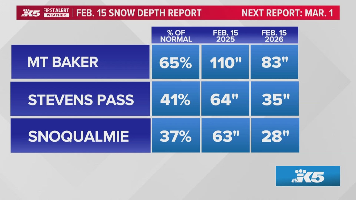
Snowpack Deficit Raises Concerns for Summer Water Supply As of February 18, statewide snowpack sits at roughly 65 % of normal, with elevations between 3,000‑5,000 ft holding only about 40 % of typical depth, especially low at Snoqualmie Pass[4]. Although upcoming storms may increase snowfall, prevailing winds parallel to the Cascades limit precipitation capture, leaving a short window before the peak snow‑pack period in early April[4]. The deficit could affect summer water storage, fire risk, and ski‑tourism, while a weak La Niña shifts toward neutral conditions with a moderate chance of a future El Niño[4].
Sources
-
1.
King5: Western Washington Braces for Week‑Long Storms with Snow, Rain, and Strong Winds: Details a week‑long sequence of storms, snow‑level forecasts down to 2,500 ft, and emphasizes heavy mountain snowfall persisting into next week.
-
2.
King5: Western Washington Braces for Storm, Wind and Snow Advisories: Highlights the BC‑origin low, seven‑day rain/snow outlook, and notes a shift of precipitation southward by Tuesday.
-
3.
King5: Wind Advisory Extends Through Sunday Morning with Gusts Up to 45 mph: Focuses on the wind advisory for foothills and San Juan Islands, describing the broader Pacific low and its impact on travel.
-
4.
King5: Washington Snowpack Lags Normal, Raising Summer Water Concerns: Reports snowpack at 65 % of normal, water‑storage implications, and the limited benefit of upcoming storms due to wind patterns.
Related Tickers
Timeline
Dec 17, 2025 – NWS reports winds ease across western Washington as a cooler pattern settles, snow levels drop and 5‑10 inches of snow are forecast for Snoqualmie and Stevens Pass Wed‑Thu; an atmospheric river expected Thursday brings ~0.5‑2 inches of rain to lowlands and 1‑2 inches of snow to the mountains, while saturated soils keep landslide and power‑outage risks high[12].
Dec 19, 2025 – NWS issues winter‑storm warnings for Washington, Oregon, Idaho, Montana and Wyoming, projecting up to three feet of snow and gusts to 60 mph; warnings run from Friday morning to Saturday afternoon, with the Cascades passes, Sawtooth Basin and Absaroka/Beartooth ranges highlighted for severe impacts[2].
Dec 20, 2025 – Heavy mountain snow falls across the Cascades ahead of Christmas, delivering 18 inches at Stevens Pass and 10 inches at Snoqualmie Pass; forecasters expect an additional 8‑12 inches through Sunday, with cumulative totals of ~1 ft at lower passes and 2‑3 ft at Mount Baker and Paradise by Tuesday, prompting travel warnings for Sunday night[11].
Dec 27, 2025 – Light snow lingers in the Puget Sound convergence zone into Saturday morning, producing up to 2 inches in Snohomish and King counties and 10‑14 inches at mountain passes; a dry, cold‑night ridge holds through Monday before a new system approaches late Wednesday or Thursday with gradual warming[9].
Dec 27, 2025 – NWS issues a Winter Weather Advisory for Cascade passes through 4 a.m. Saturday, noting snow levels dropping to ~2,500 ft and 6‑12 inches of snow across Snoqualmie, Stevens and other passes; officials warn travel could be “very difficult to impossible” and advise motorists to carry emergency kits and monitor road conditions[10].
Jan 5, 2026 – NWS issues a Winter Storm Warning for the Cascade Range, forecasting 2‑4 ft of snow from Tuesday to Thursday, low‑land rain of 0.5‑1 inch and wind gusts up to 35 mph; avalanche danger rises to “considerable” above 5,500 ft and drivers are urged to carry flashlights, food, water and check pass reports[8].
Jan 6, 2026 – NWS expands winter‑storm warnings to Washington, Oregon, Alaska, Idaho and Montana, with up to 35 inches of snow in higher terrain, winds of 45‑60 mph, and travel advisories stating “travel could be very difficult to impossible,” urging motorists to delay trips and keep emergency supplies in their vehicles[1].
Jan 29, 2026 – Snowpack across the Cascades remains far below normal despite recent snowfall, with 2‑3 inches added at Stevens Pass, 1‑2 inches at Snoqualmie Pass, and Oregon’s statewide snowpack at its second‑lowest level since 1981; SNOTEL data show deep deficits in central and southern Cascades, raising concerns for spring streamflow[7].
Feb 18, 2026 – Washington’s statewide snowpack sits at roughly 65 % of average, with elevations 3,000‑5,000 ft at only 40 % of typical depth, especially low at Snoqualmie Pass, while British Columbia’s snowpack also lags; models predict more snow but prevailing winds limit capture, and a weak La Niña shifts toward neutral, giving a 50‑60 % chance of a weak El Niño next winter[6].
Feb 22, 2026 – NWS issues a wind advisory for Snohomish, King and Pierce foothills until 10 a.m. Sunday, with east‑to‑southeast winds of 15‑25 mph and gusts up to 45 mph, and warns that dropping snow levels Sunday evening could impede mountain‑pass travel[3].
Feb 22, 2026 – Forecasters anticipate a week‑long series of storm systems battering western Washington, with a wind advisory for the San Juan Islands (gusts up to 45 mph) and a Winter Weather Advisory for the Cascades from Sunday night to Monday afternoon; snow levels are expected to fall to 2,500 ft by Wednesday and several feet of mountain snow should continue through the week[4].
Feb 22, 2026 – The offshore storm expected to linger brings rain and mountain snow, with low‑elevation highs in the low 50s °F, snow levels near 4,000 ft early in the period dropping to 2,500 ft by mid‑week, and total rainfall of 1‑3 inches at lower elevations, prompting residents to monitor updates as unsettled conditions persist into mid‑week[4].
Dive deeper (11 sub-stories)
-
Western Washington Faces Week‑Long Storms, Snow, and 45 mph Winds Starting Sunday
(2 articles)
-
King5 (Seattle, WA): Wind Advisory Extends Through Sunday Morning with Gusts Up to 45 mph
-
King5 (Seattle, WA): Washington Snowpack Lags Normal, Raising Summer Water Concerns
-
King5 (Seattle, WA): Cascade Mountains Snowpack Lags Behind Recent Snowfall
-
King5 (Seattle, WA): National Weather Service issues Winter Storm Warning as heavy snow and high winds head for the Cascades
-
Newsweek: NWS issues winter-storm warnings for five states as up to 35 inches of snow and high winds are forecast
-
King5 (Seattle, WA): Western Washington sees light snow, then dry stretch with freezing nights ahead
-
King5 (Seattle, WA): Snow could complicate post-Christmas mountain pass travel in Washington
-
King5 (Seattle, WA): Heavy mountain snow continues toward Christmas across Cascades, with up to 2–3 feet possible at some passes
-
Newsweek: Winter storm warnings issued for five states with up to three feet of snow through Saturday
-
King5 (Seattle, WA): Blustery weather eases in western Washington
All related articles (12 articles)
-
King5 (Seattle, WA): Western Washington Braces for Week‑Long Storms with Snow, Rain, and Strong Winds
-
King5 (Seattle, WA): Western Washington Braces for Storm, Wind and Snow Advisories
-
King5 (Seattle, WA): Wind Advisory Extends Through Sunday Morning with Gusts Up to 45 mph
-
King5 (Seattle, WA): Washington Snowpack Lags Normal, Raising Summer Water Concerns
-
King5 (Seattle, WA): Cascade Mountains Snowpack Lags Behind Recent Snowfall
-
King5 (Seattle, WA): National Weather Service issues Winter Storm Warning as heavy snow and high winds head for the Cascades
-
Newsweek: NWS issues winter-storm warnings for five states as up to 35 inches of snow and high winds are forecast
-
King5 (Seattle, WA): Western Washington sees light snow, then dry stretch with freezing nights ahead
-
King5 (Seattle, WA): Snow could complicate post-Christmas mountain pass travel in Washington
-
King5 (Seattle, WA): Heavy mountain snow continues toward Christmas across Cascades, with up to 2–3 feet possible at some passes
-
Newsweek: Winter storm warnings issued for five states with up to three feet of snow through Saturday
-
King5 (Seattle, WA): Blustery weather eases in western Washington
External resources (18 links)
- https://forecast.weather.gov/wwamap/wwatxtget.php?cwa=usa&wwa=Winter%20Storm%20Warning (cited 6 times)
- https://forecast.weather.gov/wwamap/wwatxtget.php?cwa=SEW&wwa=wind%20advisory (cited 2 times)
- https://forecast.weather.gov/wwamap/wwatxtget.php?cwa=SEW&wwa=winter%20weather%20advisory (cited 2 times)
- https://wsdot.com/travel/real-time/mountainpasses/Blewett (cited 2 times)
- https://wsdot.com/travel/real-time/mountainpasses/Cayuse (cited 2 times)
- https://wsdot.com/travel/real-time/mountainpasses/Chinook (cited 2 times)
- https://wsdot.com/travel/real-time/mountainpasses/Crystal-to-Greenwater (cited 2 times)
- https://wsdot.com/travel/real-time/mountainpasses/Mt.-Baker (cited 2 times)
- https://wsdot.com/travel/real-time/mountainpasses/North-Cascade-Hwy (cited 2 times)
- https://wsdot.com/travel/real-time/mountainpasses/Snoqualmie (cited 2 times)
- https://wsdot.com/travel/real-time/mountainpasses/Stevens (cited 2 times)
- https://wsdot.com/travel/real-time/mountainpasses/White (cited 2 times)
- https://forecast.weather.gov/showsigwx.php?warnzone=WAZ310&warncounty=WAC073&firewxzone=WAZ656&local_place1=4%2520Miles%2520NE%2520Bellingham%2520International%2520Airport%2520WA&product1=Wind+Advisory&lat=48.8243&lon=-122.4718 (cited 1 times)
- https://forecast.weather.gov/wwamap/wwatxtget.php?cwa=SEW&wwa=winter%2520storm%2520warning (cited 1 times)
- https://forecast.weather.gov/wwamap/wwatxtget.php?cwa=SEW&wwa=winter%2520weather%2520advisory (cited 1 times)
- https://nwcc-apps.sc.egov.usda.gov/imap/#version=169&elements=&networks=!MSNT&states=!&basins=!&hucs=&minElevation=&maxElevation=&elementSelectType=any&activeOnly=true&activeForecastPointsOnly=false&hucLabels=true&hucIdLabels=false&hucParameterLabels=true&stationLabels=&overlays=&hucOverlays=state&basinOpacity=75&basinNoDataOpacity=0&basemapOpacity=100&maskOpacity=100&mode=data&openSections=dataElement,parameter,date,basin,options,elements,location,networks,baseMaps,overlays,labels&controlsOpen=true&popup=&popupMulti=&popupBasin=&base=esriWsr&displayType=basin&basinType=wa_8&dataElement=WTEQ&depth=-8¶meter=PCTMED&frequency=DAILY&duration=I&customDuration=&dayPart=E&monthPart=B&forecastPubDay=1&forecastExceedance=50&useMixedPast=true&seqColor=1&divColor=7&scaleType=D&scaleMin=&scaleMax=&referencePeriodType=fixed&referenceBegin=1991&referenceEnd=2020&minimumYears=20&hucAssociations=true&relativeDate=-1&lat=48.124&lon=-120.914&zoom=6.9&autoExport=full,pdf,2,2,L,BL,Washington%2520SNOTEL,49.4893,44.9175,-114.8615,-125.2705 (cited 1 times)
- https://www.wsdot.com/traffic/passes/ (cited 1 times)
- https://nwac.us/avalanche-forecast/#/all/ (cited 1 times)