Central Ohio Faces Heavy Rain and Flash Flood Threat Thursday Night
Updated (2 articles)

Storm System Arrives Over Central Ohio Thursday Night A powerful storm system moved into central Ohio Thursday night after producing severe weather to the south and west earlier in the day, bringing warm, moist air that fueled showers and thunderstorms arriving from the west, with the strongest storms developing near 9 p.m. [1][2]
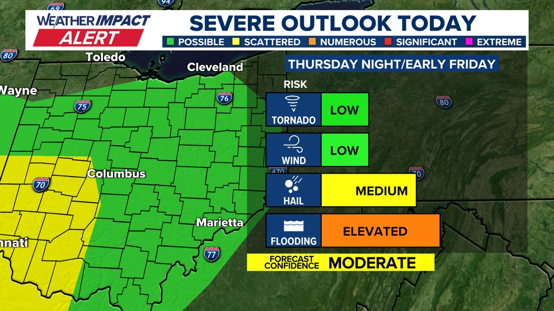
Alert Levels Elevated as Flood Risk Surpasses Wind Threat The 10TV Weather Impact Alert Day remained in effect through Thursday night, and county warnings in Fayette and Madison shifted from wind and hail to heavy rainfall and possible flash flooding, with alerts staying active until 2 a.m. [1][2]
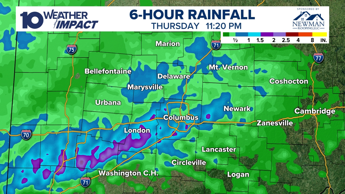
Rainfall Exceeds Two Inches, Flash Flooding Expected Radar estimates showed rainfall totals topping two inches in several locations by 11:20 p.m. Thursday, prompting flash‑flood concerns; the atmospheric setup produced a marginal level‑1 of 5 severe‑weather risk for central Ohio, with higher risk farther west and an isolated tornado not ruled out [1][2]
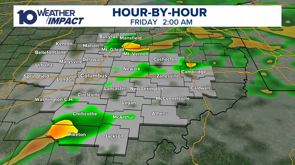
Storms Expected to Diminish by Dawn, Gusty Winds Remain Showers and storms should wane before sunrise Friday, though gusty winds are expected to linger into Friday, temperatures will fall, and the National Weather Service notes the possibility of snow showers returning by Sunday [1][2]
Sources
-
1.
WBNS: Strong Storm System Brings Severe Weather and Flood Risk to Central Ohio: Provides a comprehensive overview of the storm’s arrival, the shift from wind/hail to flooding, the 10TV alert, and rainfall totals exceeding two inches
-
2.
WBNS: Strong Storm System Moves Through Central Ohio Thursday Night: Focuses on the timing of peak thunderstorms around 9 p.m., the atmospheric conditions creating a marginal severe‑weather risk, and specific county flood warnings
Timeline
Feb 19, 2026 (Thursday night) – A strong storm system moves into central Ohio after spawning severe weather to the south and west earlier, and warm, moist air fuels showers and thunderstorms that peak around 9 p.m. [1][2]
Feb 19, 2026 (Thursday) – 10TV issues a Weather Impact Alert Day that stays in effect through Thursday night to warn of ongoing severe‑weather potential across central Ohio. [1][2]
Feb 19, 2026 (Early Thursday night) – County warnings in Fayette and Madison shift from wind and hail to heavy rain and possible flash flooding, with alerts remaining active until 2 a.m. Friday. [1][2]
Feb 19, 2026 (Throughout the night) – A nearby low‑pressure system, an advancing warm front ahead of a cold front, and moderate wind shear create a marginal level‑1 of 5 severe‑weather risk for central Ohio, and an isolated tornado cannot be ruled out. [1][2]
Feb 19, 2026 (11:20 p.m.) – Radar‑estimated rainfall tops 2 inches in several locations, prompting flash‑flooding concerns and urging caution on roads and flood‑prone areas. [1][2]
Feb 20, 2026 (Early Friday) – Showers and storms wane before sunrise, though gusty winds linger into Friday and temperatures begin to fall. [1][2]
Feb 20‑22, 2026 (Friday to Sunday) – Gusty winds persist Friday, and snow showers become possible by Sunday as the system moves out of the region. [1][2]
External resources (4 links)
- https://www.facebook.com/AaronWhiteTV (cited 2 times)
- https://www.facebook.com/ChrisTomer (cited 2 times)
- https://www.facebook.com/GarofaloWX (cited 2 times)
- https://www.facebook.com/mikebehrenswx (cited 2 times)