Ohio Snow Slows, Roads Remain Slick While Schools Close; Clearing Expected Afternoon
Updated (2 articles)
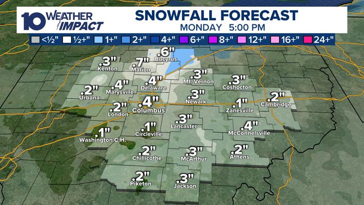
Snowfall Ends but Temperatures Stay Below Freezing Overnight snow has largely wound down, yet forecasts call for up to 0.5 in of additional snow this afternoon, keeping pavement temperatures at or below freezing and driving wind‑chill values into the teens and low‑20s [1][2]. Strong gusty winds continue to exacerbate the cold feel, prompting caution for anyone outdoors. Meteorologists note that the lingering sub‑freezing air will maintain icy conditions on untreated road surfaces for several more hours.
Road Hazards Concentrated on Bridges and Overpasses The 10 Weather Impact Alert remains active as slick spots persist, especially on bridges, overpasses and ramps where rapid icing occurs [1][2]. Road crews are scheduled to begin clearing efforts this afternoon, but untreated sections may stay hazardous until temperatures rise. Drivers are urged to reduce speed and allow extra stopping distance on these vulnerable stretches.
Over 100 School Districts Shut or Delay Classes More than one hundred Ohio school districts have either closed entirely or issued a two‑hour delay for Monday morning, affecting thousands of students and staff [1][2]. Each district posted its status on the station’s closures page, providing a centralized list for parents. The widespread closures reflect the severity of travel risks and the priority placed on student safety.
Moisture Band From Larger Storm Reaches Ohio primary low‑pressure system moving toward the East Coast and New England pulled a moisture band into Ohio on Sunday, generating scattered snow showers across the state [1][2]. While the main impact of the storm will be felt elsewhere, the residual moisture continues to produce light snowfall and lingering slick conditions in Ohio.
Warmer Weather Projected for Mid‑Week Forecast models indicate a shift to milder air by mid‑next week, with daytime highs climbing into the 40 °F range [1][2]. This warming trend should melt remaining ice on roads and allow schools to resume normal schedules. Residents can expect a gradual return to typical winter‑time travel conditions after the brief cold snap.
Sources
-
1.
WBNS (Columbus, OH): Ohio Snow Slows, Roads Remain Slick, Schools Delayed – Details the snowfall slowdown, ongoing slick roads, wind‑chill values, and the extensive school closures affecting over 100 districts .
-
2.
WBNS (Columbus, OH): Snow clearing this afternoon after slick roads and school delays – Emphasizes the activation of the 10 Weather Impact Alert, the anticipated half‑inch of additional snow, and the planned afternoon clearing operations while reiterating school impacts .
Related Tickers
Timeline
Feb 19, 2026 – Moisture from a larger low‑pressure system that will move toward the East Coast and New England pulls into Ohio, generating scattered snow showers across the state [1][2].
Feb 19‑20, 2026 (overnight) – Overnight snow blankets Ohio, leaving road surfaces icy and prompting a 10 Weather Impact Alert for snow emergencies on Monday morning [1][2].
Feb 20, 2026 (early morning) – The Ohio Weather Service issues a 10 Weather Impact Alert, warning drivers of slick roads, especially untreated bridges, overpasses and ramps [2].
Feb 20, 2026 (morning) – More than 100 Ohio school districts close or issue a two‑hour delay for Monday classes, affecting thousands of students [1][2].
Feb 20, 2026 (mid‑day) – Forecast calls for up to an additional 0.5 inches of snow this afternoon, keeping pavement temperatures at or below freezing and maintaining hazardous conditions on bridges and ramps [1][2].
Feb 20, 2026 (throughout the day) – Temperatures stay at or below freezing with gusty winds, driving wind‑chill values into the teens and low‑20s, raising frostbite and traction risks [1][2].
Feb 20, 2026 (evening) – Snow begins to wind down, but flurries remain possible overnight; “Snow winding down, flurries possible tonight” is reported as crews continue clearing slick surfaces [1].
Feb 24‑25, 2026 (mid‑next week) – Meteorologists project a shift to milder weather, with daytime highs rising into the 40 °F range, easing travel concerns [1][2].