Western Washington Faces Mixed Rain, Lowland Snow and Snowpack Deficit Through Week
Updated (10 articles)
Thursday Mixed Rain and Wet‑Snow Followed by Sunny Breaks Thursday brings a mix of rain and wet‑snow showers that give way to afternoon sunbreaks, with highs in the upper 30s to low 40s °F; snow levels rise from 300‑500 ft to 500‑700 ft. Friday remains partly sunny but cool, lows dropping to the upper 20s‑mid 30s °F and daytime highs staying in the low‑mid 40s °F. Saturday may produce spotty 1‑2 inches of wet snow across Hood Canal and the western Kitsap Peninsula before turning to rain, while snow levels climb to near 1,500 ft and highs reach the mid‑upper 40s °F. Sunday‑Monday feature continued rain with mountain snow as snow levels rise to about 2,000 ft on Sunday and 3,000 ft on Monday, keeping lows in the upper 30s‑low 40s °F and highs in the upper 40s‑low 50s °F. Cold Fraser River outflow winds drive wind chills to 10‑12 °F overnight, though winds ease by midday [1].
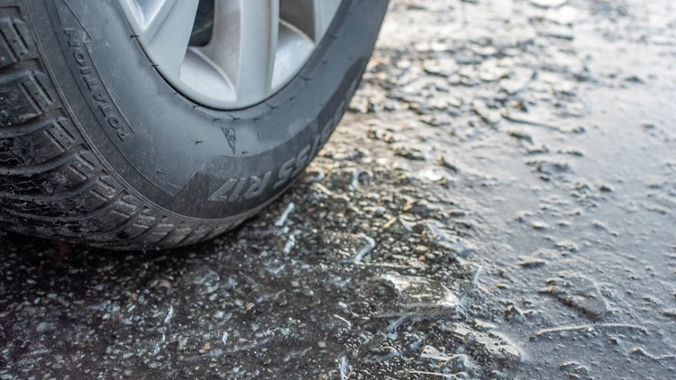
Wednesday‑Thursday Lowland Snow Bursts Disrupt Schools weak convergence zone produced brief low‑elevation snow Wednesday evening into Thursday across Snohomish, King and Pierce counties, with Bothell (≈300 ft) and Maltby (≈400 ft) receiving measurable snow. Granite Falls schools operated on a two‑hour delay Thursday and cancelled classes Wednesday in response to the snowfall. Snow levels have hovered between 500‑1,000 ft this week and are expected to stay in that band through Friday, though heavier showers could temporarily lower them. Accumulations remain minimal, leaving roadways mostly slushy rather than snow‑covered, with only grassy and elevated surfaces seeing trace buildup. Earlier spotty snow fell in Marysville, Lake Stevens, the Olympic Peninsula and near Sea‑Tac, melting quickly [2].
Snow Levels Fluctuate From 500 ft to 1,500 ft, Mountains Gain Inches Forecasts call for snow levels dropping to about 500 ft Wednesday morning, allowing low‑land snow from the Kitsap Peninsula to the coastal foothills, then rising to roughly 1,500 ft by Saturday as Arctic air weakens. The mixed rain‑snow scenario could produce slick roads during brief precipitation breaks when temperatures fall below freezing. Mountain regions are set to add 6‑12 inches of snow by week’s end, contributing to an estimated 1‑2 feet of new snow from Saturday through Wednesday across higher elevations. Despite the low‑land bursts, overall impacts on lowland communities are expected to remain limited [4][1].
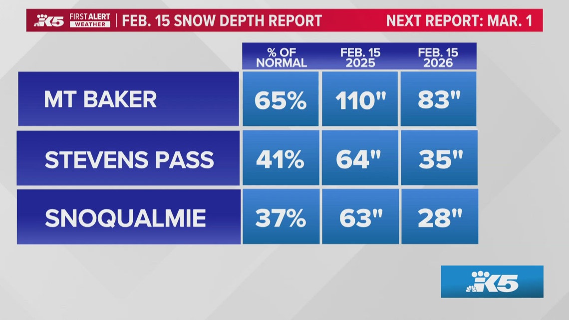
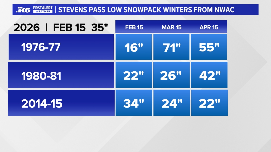
Statewide Snowpack Lags at 65 % of Normal, Threatening Summer Water As of mid‑February, the Cascades hold only about two‑thirds of average snow, with elevations between 3,000‑5,000 ft at just 40 % of typical depth, raising concerns for summer water storage. Snoqualmie Pass shows the greatest deficit, while Paradise on Mt. Rainier and Mt. Baker retain near‑normal levels. Models predict additional snowfall this week, but prevailing winds parallel the Cascades, limiting precipitation capture and leaving 6‑8 weeks for the snowpack to recover before the April peak. The weak La Niña shifting toward neutral adds uncertainty, with a 50‑60 % chance of a weak El Niño next winter [3].
Sources
-
1.
King5: Puget Sound Weather Outlook Through Early Next Week: Details a mixed rain/wet‑snow Thursday, rising snow levels, weekend rain with mountain snow, wind chills to 10‑12 °F, and 1‑2 ft mountain accumulation through mid‑next week .
-
2.
King5: Spotty Lowland Snow Hits Snohomish, King, and Pierce Counties: Reports Wednesday‑Thursday low‑elevation snow bursts, school delays in Granite Falls, snow levels 500‑1,000 ft, and minimal road accumulation .
-
3.
King5: Washington Snowpack Lags Normal, Raising Summer Water Concerns: Highlights statewide snowpack at ~65 % of normal, severe deficit at Snoqualmie Pass, and implications for water supply and fire risk .
-
4.
King5: Lowland Snow Possible Wednesday as Western Washington Precipitation Increases: Forecasts snow levels dropping to 500 ft Wednesday, mixed rain‑snow across Kitsap and coastal foothills, mountain snowfall of 6‑12 inches, and rising snow levels to 1,500 ft by Saturday .
Timeline
Dec 17, 2025 – Winds ease and a cooler, more seasonal pattern settles across western Washington, prompting a Winter Storm Warning that promises 5‑10 inches of snow at Snoqualmie and Stevens Passes and a half‑inch of rain in lowlands, while forecasters warn of falling trees, power outages and landslides on saturated ground; an atmospheric river brushes the region Thursday, bringing ½‑2 inches of rain to the mountains and half an inch to the lowlands [10].
Dec 20, 2025 – Heavy mountain snow intensifies ahead of Christmas, with Stevens Pass topping 18 inches and Snoqualmie Pass around 10 inches, and models project a cumulative 1 ft at those passes and 2‑3 ft at Mt. Baker/Paradise by early Tuesday; officials caution that travel will worsen Sunday night and advise drivers to avoid mountain passes after dark [9].
Dec 27, 2025 – Light snow lingers in the Puget Sound convergence zone into Saturday morning, depositing up to 2 inches in Snohomish and King counties while mountain passes record 10‑14 inches, then a dry, cold‑night ridge holds through Monday before a new system approaches late Wednesday or Thursday with gradual warming [7].
Dec 27, 2025 – The National Weather Service issues a Winter Weather Advisory for Cascade passes, noting snow levels dropping to ~2,500 ft on Friday and forecasting 6‑12 inches of snow across Snohomish, King, Whatcom and Skagit counties, while WSDOT urges travelers to carry emergency kits and to check road conditions before attempting Saturday travel [8].
Jan 8, 2026 – A colder system drives snow levels down to about 500 ft overnight, creating a brief wet‑snow mix that reaches sea level Thursday morning but leaves little accumulation; meanwhile, the Cascades receive an additional 2‑4 feet of snow under a Winter Storm Warning, and a High Surf Advisory runs along the coast [6].
Jan 29, 2026 – Despite fresh snowfall, the Cascade snowpack remains far below normal, with Stevens Pass gaining only 2‑3 inches, Snoqualmie Pass 1‑2 inches, and Oregon’s statewide snowpack at its second‑lowest level since 1981; early‑season warmth and rain limited snow gains, raising concerns for spring streamflow and water supply [5].
Feb 17, 2026 – Snow levels plunge to ~500 ft Wednesday morning, prompting meteorologist Rich Marriott to note a possible rain‑snow mix from the Kitsap Peninsula to coastal foothills, while weather anchor Parella Lewis stresses that widespread lowland impacts should stay limited; mountains are slated to add 6‑12 inches of snow by week’s end, and Arctic air will lift snow levels to ~1,500 ft by Saturday [4].
Feb 18, 2026 – Statewide snowpack sits at roughly 65 % of normal, with Snoqualmie Pass showing the greatest deficit and Paradise on Mt. Rainier near‑normal; officials cite past El Niño‑linked winters of 1976‑77, 1980‑81 and 2014‑15 as comparable low‑snow years, warn that the weak La Niña shifting toward neutral raises a 50‑60 % chance of a weak El Niño next winter, and flag potential impacts on summer water storage, fire risk and ski tourism [3].
Feb 19, 2026 – Spotty lowland snow bursts across Snohomish, King and Pierce counties Wednesday‑Thursday, with Bothell (≈300 ft) and Maltby (≈400 ft) receiving snow; Granite Falls schools operate on a two‑hour delay Thursday and cancel Wednesday classes, while snow levels hover between 500‑1,000 ft through Friday and roads remain mostly slush with minimal accumulation [2].
Feb 19, 2026 – The weather outlook calls for mixed rain and wet‑snow showers Thursday, partly sunny but cool Friday, and 1‑2 inches of wet snow in Hood Canal Saturday before changing to rain; Sunday‑Monday bring rain with mountain snow as snow levels rise to 2,000‑3,000 ft, and a series of systems through mid‑next week is expected to deposit 1‑2 feet of new snow in the Cascades, while cold Fraser River outflow winds drive wind chills to 10‑12 °F [1].
All related articles (10 articles)
-
King5 (Seattle, WA): Puget Sound Weather Outlook Through Early Next Week
-
King5 (Seattle, WA): Spotty Lowland Snow Hits Snohomish, King, and Pierce Counties
-
King5 (Seattle, WA): Washington Snowpack Lags Normal, Raising Summer Water Concerns
-
King5 (Seattle, WA): Lowland Snow Possible Wednesday as Western Washington Precipitation Increases
-
King5 (Seattle, WA): Cascade Mountains Snowpack Lags Behind Recent Snowfall
-
King5 (Seattle, WA): Snow levels fall overnight across western Washington, raising chance of lowland wet snow and slick roads
-
King5 (Seattle, WA): Western Washington sees light snow, then dry stretch with freezing nights ahead
-
King5 (Seattle, WA): Snow could complicate post-Christmas mountain pass travel in Washington
-
King5 (Seattle, WA): Heavy mountain snow continues toward Christmas across Cascades, with up to 2–3 feet possible at some passes
-
King5 (Seattle, WA): Blustery weather eases in western Washington
External resources (11 links)
- https://forecast.weather.gov/wwamap/wwatxtget.php?cwa=SEW&wwa=winter%2520weather%2520advisory (cited 1 times)
- https://nwcc-apps.sc.egov.usda.gov/imap/#version=169&elements=&networks=!MSNT&states=!&basins=!&hucs=&minElevation=&maxElevation=&elementSelectType=any&activeOnly=true&activeForecastPointsOnly=false&hucLabels=true&hucIdLabels=false&hucParameterLabels=true&stationLabels=&overlays=&hucOverlays=state&basinOpacity=75&basinNoDataOpacity=0&basemapOpacity=100&maskOpacity=100&mode=data&openSections=dataElement,parameter,date,basin,options,elements,location,networks,baseMaps,overlays,labels&controlsOpen=true&popup=&popupMulti=&popupBasin=&base=esriWsr&displayType=basin&basinType=wa_8&dataElement=WTEQ&depth=-8¶meter=PCTMED&frequency=DAILY&duration=I&customDuration=&dayPart=E&monthPart=B&forecastPubDay=1&forecastExceedance=50&useMixedPast=true&seqColor=1&divColor=7&scaleType=D&scaleMin=&scaleMax=&referencePeriodType=fixed&referenceBegin=1991&referenceEnd=2020&minimumYears=20&hucAssociations=true&relativeDate=-1&lat=48.124&lon=-120.914&zoom=6.9&autoExport=full,pdf,2,2,L,BL,Washington%2520SNOTEL,49.4893,44.9175,-114.8615,-125.2705 (cited 1 times)
- https://wsdot.com/travel/real-time/mountainpasses/Blewett (cited 1 times)
- https://wsdot.com/travel/real-time/mountainpasses/Cayuse (cited 1 times)
- https://wsdot.com/travel/real-time/mountainpasses/Chinook (cited 1 times)
- https://wsdot.com/travel/real-time/mountainpasses/Crystal-to-Greenwater (cited 1 times)
- https://wsdot.com/travel/real-time/mountainpasses/Mt.-Baker (cited 1 times)
- https://wsdot.com/travel/real-time/mountainpasses/North-Cascade-Hwy (cited 1 times)
- https://wsdot.com/travel/real-time/mountainpasses/Snoqualmie (cited 1 times)
- https://wsdot.com/travel/real-time/mountainpasses/Stevens (cited 1 times)
- https://wsdot.com/travel/real-time/mountainpasses/White (cited 1 times)