Western Washington Faces Week‑Long Storms, Strong Winds, and Snowpack Concerns
Updated (10 articles)
Multi‑Front Storm System Brings Rain, Snow, and Gusty Winds succession of offshore low‑pressure systems will affect western Washington from Saturday through the following week, delivering rain to valleys and wet snow above 1,500‑2,000 ft while Hood Canal and the western Kitsap Peninsula remain mostly dry early on [1][2]. Snow‑laden bands move inland Saturday afternoon, producing 1‑2 inches of wet snow on the peninsula before transitioning to rain in lowlands and heavier snow at higher elevations [2]. By mid‑week the system persists, keeping temperatures in the low 50s and adding 1‑3 inches of rain to lower elevations [1].
Wind Advisory Enforced for Coastal and Foothill Zones The National Weather Service has issued a Wind Advisory for the North and Central Coast and the Cascade Foothills through 10 a.m. Sunday, with easterly gap winds gusting 40‑50 mph [1][2]. Coastal gusts may reach 50 mph, prompting warnings for the North and Central Coast and the Cascade Foothills [1]. Residents are urged to secure loose objects and limit travel during peak gust periods [1].
Snow Levels Rise Then Fall, Mountain Accumulations Expected Snow levels start near 1,500‑2,000 ft Saturday, climb to about 3,500‑4,000 ft on Sunday and Monday, then gradually descend to 2,500‑3,000 ft by Thursday [1][2][4]. Mountain forecasts call for 3‑6 inches of snow, increasing to heavier amounts above 4,500 ft and potentially several feet by week’s end [1][2]. Lowland rain totals range from 0.1‑0.75 inches, with coastal areas receiving up to 1.5 inches, while the mountains could see 6‑12 inches by the weekend [4].
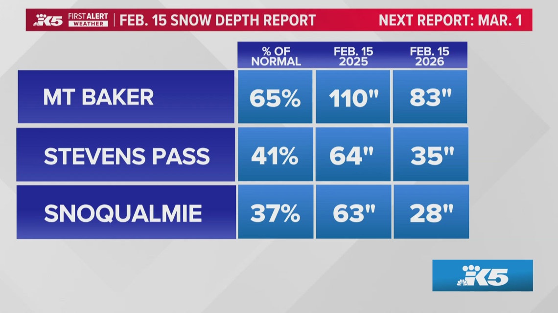
Snowpack Deficit Heightens Summer Water Supply Concerns As of February 18, the Cascades hold roughly 65 % of average snowpack, with elevations between 3,000‑5,000 ft at only 40 % of normal depth [3]. Snoqualmie Pass shows the greatest shortfall, threatening water storage for the Columbia Basin’s summer irrigation needs [3]. Models predict additional snowfall this week, but prevailing winds parallel the range, limiting precipitation capture and leaving the region vulnerable to summer water shortages [3].
Sources
-
1.
King5: Western Washington Braces for Week‑Long Storm Sequence: details a series of low‑pressure fronts delivering rain, snow, and 40‑50 mph gusts, with wind advisories and mountain snow forecasts through next week .
-
2.
King5: Western Washington Braces for Rain, Snow and Strong Winds Through Next Week: emphasizes increasing rain and lowland snow Saturday, wind advisory specifics, and model projections of multiple feet of mountain snow .
-
3.
King5: Washington Snowpack Lags Normal, Raising Summer Water Concerns: reports statewide snowpack at 65 % of normal, severe deficits at Snoqualmie Pass, and implications for summer water supply .
-
4.
King5: Lowland Snow Possible Wednesday as Western Washington Precipitation Increases: notes a temporary drop in snow levels to 500‑1,000 ft on Wednesday, mixed rain‑snow impacts on the Kitsap Peninsula, and mountain snow buildup of 6‑12 inches by week’s end .
Related Tickers
Timeline
Dec 17, 2025 – Winds ease across western Washington as a cooler, more seasonal pattern settles; forecasters note “winds ease, cooler pattern takes hold” and predict 5‑10 inches of snow at Snoqualmie and Stevens Pass, while an atmospheric river brushes the region bringing about half an inch of rain to lowlands and 1‑2 inches to the mountains, raising concerns for urban flooding, landslides, and power outages[10].
Dec 20, 2025 – Heavy mountain snow returns ahead of Christmas, with Stevens Pass topping 18 inches and Snoqualmie Pass around 10 inches; officials warn that “travel conditions likely to worsen Sunday evening” and advise drivers to avoid Sunday night travel as cumulative totals could reach 1 foot at lower passes and 2‑3 feet at Mount Baker and Paradise by early next week[9].
Dec 27, 2025 – Light snow lingers in the Puget Sound convergence zone into Saturday morning, depositing up to 2 inches in Snohomish and King counties while mountain passes receive 10‑14 inches; a ridge brings a dry, cold‑night pattern through Monday, with a new system expected late Wednesday or Thursday to bring “gradual warming of a few degrees”[7].
Dec 27, 2025 – The National Weather Service issues a Winter Weather Advisory for Cascade passes, noting snow levels dropping to ~2,500 ft on Friday and forecasting 6‑12 inches of snow across Snohomish, King, Whatcom and Skagit counties; travelers are urged to “check weather before traveling Saturday” and to carry emergency kits per WSDOT guidance[8].
Jan 8, 2026 – A colder system pushes snow levels down to about 1,500 ft by Wednesday and as low as 500 ft overnight, creating spotty lowland wet‑snow and slick roads; despite limited accumulation at sea level, the Cascades remain under a Winter Storm Warning with 2‑4 feet of additional snow expected, prompting “wet, slippery roads rather than significant snowfall” warnings[6].
Jan 29, 2026 – Cascade snowpack remains far below normal despite recent snowfall, with Stevens Pass gaining only 2‑3 inches and Snoqualmie Pass 1‑2 inches; Oregon’s snowpack sits at its second‑lowest level since 1981, and SNOTEL data show deep deficits in central and southern Cascades, raising concerns for spring streamflow and water resources[5].
Feb 17, 2026 – Snow levels drop to about 500 ft Wednesday morning, allowing low‑elevation wet‑snow and a rain‑snow mix from the Kitsap Peninsula to coastal foothills; meteorologist Rich Marriott says “a mixed precipitation type could affect” these areas, while weather anchor Parella Lewis notes that “overall effect on lowland communities should remain limited,” though slick roads may develop during breaks in precipitation[4].
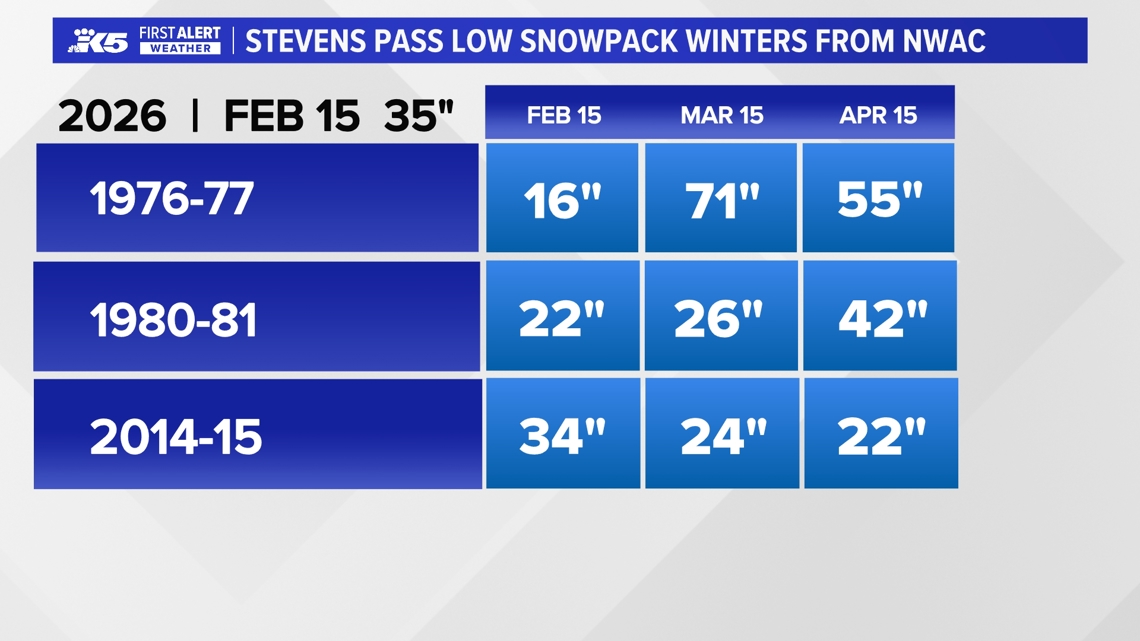
Feb 18, 2026 – Statewide snowpack sits at roughly 65 % of normal, with Snoqualmie Pass at only 40 % of typical depth, threatening summer water supplies; the article links the “dry winter” to past El Niño‑linked seasons of 1976‑77, 1980‑81 and 2014‑15, and notes a 50‑60 % chance of a weak El Niño next winter, which could influence fire risk and ski tourism[3].
Feb 21, 2026 – Forecast calls for increasing rain and lowland snow Saturday, with a Wind Advisory for the Cascade Foothills and North/Central Coast through 10 a.m. Sunday as gusts reach 40‑50 mph; multiple fronts driven by an offshore low will deliver rain, sleet, wet snow and breezy conditions through the week, and models predict “several feet of mountain snow by the end of next week” while lowland temperatures rise to the low 50s[2].
Feb 22, 2026 – A week‑long storm sequence brings rain, snow, and gusty easterly winds (40‑50 mph) from the weekend through next week, with snow levels climbing to 2,000‑2,500 ft then 3,500 ft and falling to 2,500‑3,000 ft by mid‑week; forecasters warn that “multiple feet of mountain snow and 1‑3 inches of rain at lower elevations by week’s end” are expected and urge residents to stay updated on evolving conditions[1].
All related articles (10 articles)
-
King5 (Seattle, WA): Western Washington Braces for Week‑Long Storm Sequence
-
King5 (Seattle, WA): Western Washington Braces for Rain, Snow and Strong Winds Through Next Week
-
King5 (Seattle, WA): Washington Snowpack Lags Normal, Raising Summer Water Concerns
-
King5 (Seattle, WA): Lowland Snow Possible Wednesday as Western Washington Precipitation Increases
-
King5 (Seattle, WA): Cascade Mountains Snowpack Lags Behind Recent Snowfall
-
King5 (Seattle, WA): Snow levels fall overnight across western Washington, raising chance of lowland wet snow and slick roads
-
King5 (Seattle, WA): Western Washington sees light snow, then dry stretch with freezing nights ahead
-
King5 (Seattle, WA): Snow could complicate post-Christmas mountain pass travel in Washington
-
King5 (Seattle, WA): Heavy mountain snow continues toward Christmas across Cascades, with up to 2–3 feet possible at some passes
-
King5 (Seattle, WA): Blustery weather eases in western Washington
External resources (13 links)
- https://forecast.weather.gov/wwamap/wwatxtget.php?cwa=SEW&wwa=wind%20advisory (cited 1 times)
- https://forecast.weather.gov/wwamap/wwatxtget.php?cwa=SEW&wwa=wind%2520advisory (cited 1 times)
- https://forecast.weather.gov/wwamap/wwatxtget.php?cwa=SEW&wwa=winter%2520weather%2520advisory (cited 1 times)
- https://nwcc-apps.sc.egov.usda.gov/imap/#version=169&elements=&networks=!MSNT&states=!&basins=!&hucs=&minElevation=&maxElevation=&elementSelectType=any&activeOnly=true&activeForecastPointsOnly=false&hucLabels=true&hucIdLabels=false&hucParameterLabels=true&stationLabels=&overlays=&hucOverlays=state&basinOpacity=75&basinNoDataOpacity=0&basemapOpacity=100&maskOpacity=100&mode=data&openSections=dataElement,parameter,date,basin,options,elements,location,networks,baseMaps,overlays,labels&controlsOpen=true&popup=&popupMulti=&popupBasin=&base=esriWsr&displayType=basin&basinType=wa_8&dataElement=WTEQ&depth=-8¶meter=PCTMED&frequency=DAILY&duration=I&customDuration=&dayPart=E&monthPart=B&forecastPubDay=1&forecastExceedance=50&useMixedPast=true&seqColor=1&divColor=7&scaleType=D&scaleMin=&scaleMax=&referencePeriodType=fixed&referenceBegin=1991&referenceEnd=2020&minimumYears=20&hucAssociations=true&relativeDate=-1&lat=48.124&lon=-120.914&zoom=6.9&autoExport=full,pdf,2,2,L,BL,Washington%2520SNOTEL,49.4893,44.9175,-114.8615,-125.2705 (cited 1 times)
- https://wsdot.com/travel/real-time/mountainpasses/Blewett (cited 1 times)
- https://wsdot.com/travel/real-time/mountainpasses/Cayuse (cited 1 times)
- https://wsdot.com/travel/real-time/mountainpasses/Chinook (cited 1 times)
- https://wsdot.com/travel/real-time/mountainpasses/Crystal-to-Greenwater (cited 1 times)
- https://wsdot.com/travel/real-time/mountainpasses/Mt.-Baker (cited 1 times)
- https://wsdot.com/travel/real-time/mountainpasses/North-Cascade-Hwy (cited 1 times)
- https://wsdot.com/travel/real-time/mountainpasses/Snoqualmie (cited 1 times)
- https://wsdot.com/travel/real-time/mountainpasses/Stevens (cited 1 times)
- https://wsdot.com/travel/real-time/mountainpasses/White (cited 1 times)