Snow Returns to Central Ohio Friday, Cold Lingers as Forecast Predicts Gradual Warm‑Up
Updated (2 articles)
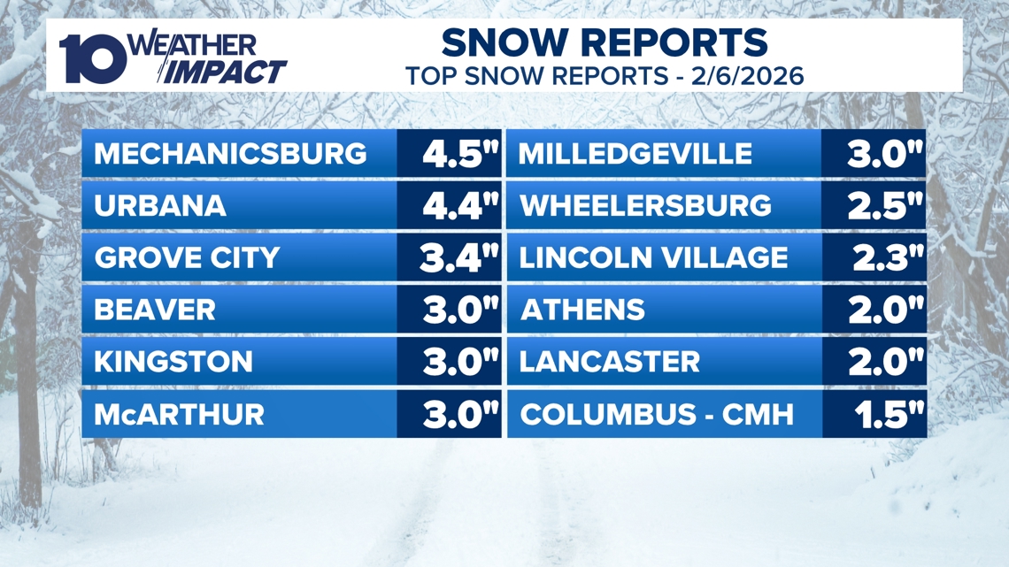
Friday snowfall delivers 1‑3 inches across most of central Ohio Meteorologists recorded widespread snowfall Friday, with most locations receiving between one and three inches of snow; isolated spots such as Mechanicsburg (4.5 in) and Urbana (4.4 in) exceeded three inches, marking the heaviest accumulations of the event [1]. The snow moved out quickly, leaving a brief lull before colder air returned After the band passed, temperatures dropped sharply, setting the stage for sub‑zero wind chills later Saturday [1].
Saturday wind‑chill impacts sub‑zero but advisories expire Bitter cold and sub‑zero wind chills persisted through Saturday, prompting cold‑weather advisories that expired later that day, reducing official alerts for residents [1]. Calm winds expected early Sunday will limit wind‑chill severity Forecast models show winds diminishing overnight, which should prevent further wind‑chill amplification as the weekend progresses [1].
Saturday night turns mostly cloudy with low single‑digit lows The forecast calls for mostly cloudy skies Saturday night, with temperatures expected to linger in the low single digits through early Sunday, maintaining a chilly overnight environment [1]. Sunday brings a modest warm‑up and a new snow band Sunday afternoon temperatures rise to the mid‑low 20s, while a secondary snow band could add an additional one to two inches in the hardest‑hit areas, extending the precipitation threat [1].
Monday and Tuesday signal gradual warming into the 30s‑40s Partly cloudy conditions Monday are projected to produce highs in the 30s, followed by Tuesday highs reaching the 40s, indicating a steady temperature increase [1]. Wednesday may reintroduce rain or snow as temperatures hover near 40 °F Early‑week models suggest a chance of mixed precipitation as early as Wednesday, and the 10 Weather Impact team warns that rain or snow chances could repeat through the remainder of the week before warmer air fully settles in [1].
Timeline
Dec 2025 (Saturday) – Central Ohio receives up to 9 inches of snow, creating slick roads and reduced visibility as the storm moves through the region [2].
Dec 2025 (Sunday‑Monday) – Wind gusts reach 25 mph, blowing snow cuts visibility, and wind chills plunge to –5 °F to –10 °F or lower; Cold Weather Advisories cover the area and several counties declare snow emergencies [2].
Dec 2025 (Sunday) – Churches and community events face closures and delays due to hazardous travel conditions [2].
Feb 2, 2026 (Friday) – A new snowfall band drops 1‑3 inches across central Ohio, with isolated totals of 4.4‑4.5 inches in Urbana and Mechanicsburg [1].
Feb 3, 2026 (Saturday) – Bitter cold and sub‑zero wind chills persist; cold‑weather advisories expire Saturday, and calm winds are expected to limit wind‑chill impact early Sunday [1].
Feb 3, 2026 (Saturday night) – Skies turn mostly cloudy overnight, and temperatures fall to the low single digits through early Sunday [1].
Feb 4, 2026 (Sunday) – Mid‑low 20s temperatures arrive with mostly cloudy skies, and a secondary snow band adds another 1‑2 inches in the hardest‑hit areas [1].
Feb 5, 2026 (Monday) – Partly cloudy conditions bring highs in the 30s, marking the start of a gradual warm‑up [1].
Feb 6, 2026 (Tuesday) – Highs climb into the 40s; forecasters note a possible rain‑or‑snow chance as early as Wednesday with temperatures near 40 °F [1].
Feb 7, 2026 (Wednesday onward) – The 10 Weather Impact team warns residents to expect repeated rain or snow chances through the end of the week, while warmer air is projected to arrive soon [1].