Western Washington Faces Week‑Long Rain, Snow, and Strong Winds Starting Feb 23
Updated (10 articles)
Series of Storms Will Persist Through Early Next Week succession of offshore storm systems will sweep western Washington from the weekend into next week, delivering repeated rounds of rain, mountain snow, and gusty winds with daytime highs in the low‑50s °F. Snow levels are forecast to begin near 4,000 ft early in the period and gradually drop to around 2,500 ft by Wednesday, then rise to roughly 3,000 ft on Thursday [1]. Models indicate the Cascades could accumulate several feet of snow by week’s end, while lower elevations are expected to see only 1–3 inches of rain [1].
Lowland Snow Reaches Below 500 Feet in Several Counties Brief bursts of snow fell Wednesday‑Thursday across Snohomish, King, and Pierce counties, with Bothell (≈300 ft) and Maltby (≈400 ft) reporting measurable snowfall [2]. Snow levels have hovered between 500 ft and 1,000 ft and are expected to remain in that band through Friday, though heavier showers could temporarily lower the threshold [2]. Accumulations stayed minimal, leaving roadways mostly slushy and prompting a two‑hour delay for Granite Falls schools and a Wednesday cancellation [2].
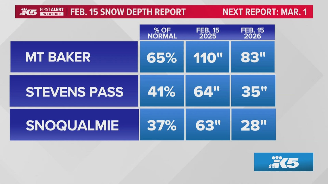
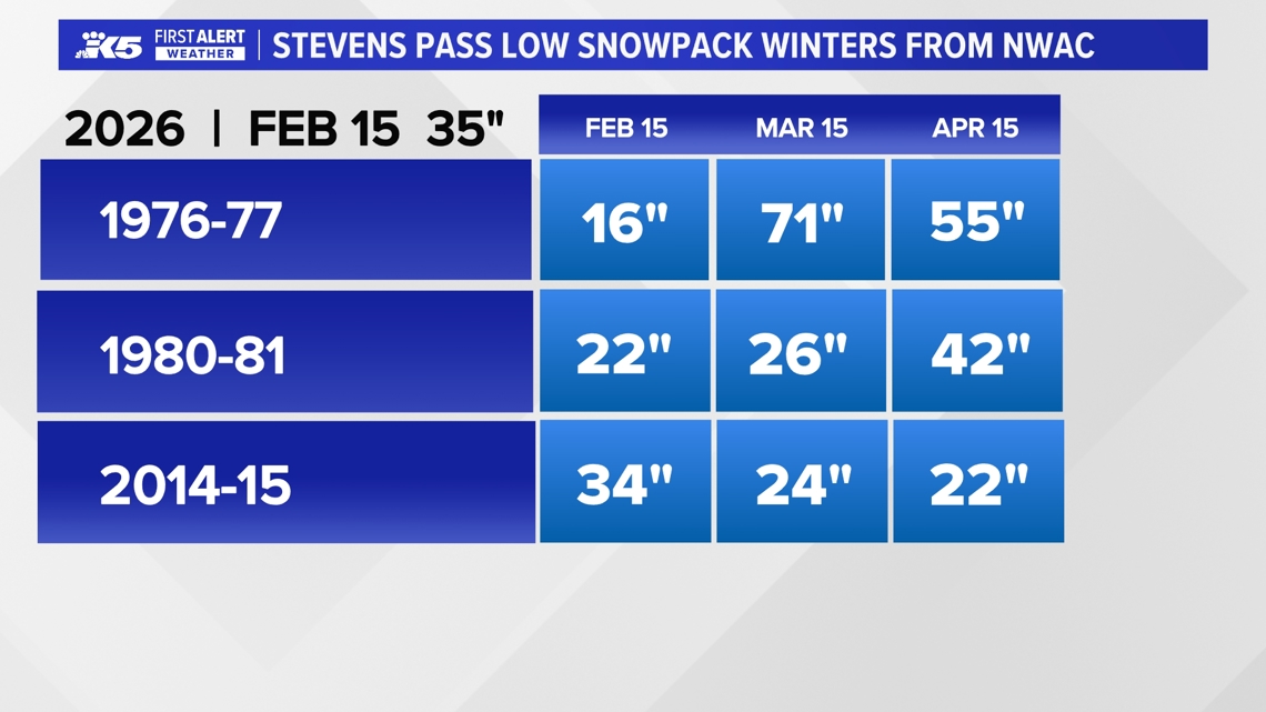
Snowpack Deficit Raises Summer Water‑Supply Concerns As of mid‑February, the Cascades hold roughly 65 % of average snowpack, with elevations between 3,000 ft and 5,000 ft at only 40 % of typical depth [3]. Snoqualmie Pass shows the greatest shortfall, while higher sites on Mt. Rainier and Mt. Baker remain nearer to normal, a pattern that mirrors past El Niño‑linked winters [3]. Forecasts call for additional snowfall, but prevailing winds parallel the range, limiting precipitation capture and leaving the region vulnerable to reduced summer water storage [3].
Snow Levels Expected to Rise After Mid‑Week Arctic Influx Snow is projected to drop to about 500 ft Wednesday morning, creating low‑elevation snow potential from the Kitsap Peninsula to coastal foothills, with a rain‑snow mix likely in those zones [4]. Slick conditions may develop on roads that briefly clear before refreezing during precipitation breaks [4]. Mountains should add 6–12 inches of snow by week’s end, after which Arctic air will lift snow levels to roughly 1,500 ft by Saturday, reducing lowland snow chances thereafter [4].
Sources
-
1.
King5: Western Washington Braces for Repeated Rain, Snow and Winds Through Next Week – Details the multi‑day storm pattern, projected snow‑level descent, and mountain snowfall totals .
-
2.
King5: Spotty Lowland Snow Hits Snohomish, King, and Pierce Counties – Highlights brief low‑elevation snow events, school disruptions, and minimal accumulations .
-
3.
King5: Washington Snowpack Lags Normal, Raising Summer Water Concerns – Reports statewide snowpack at 65 % of normal, emphasizes deficits at Snoqualmie Pass, and discusses implications for water resources .
-
4.
King5: Lowland Snow Possible Wednesday as Western Washington Precipitation Increases – Focuses on Wednesday low‑elevation snow potential, rain‑snow mix, road‑safety issues, and the upcoming rise in snow levels .
Related Tickers
Timeline
Dec 17, 2025 – Winds ease and a cooler, more seasonal pattern settles across western Washington, with 5‑10 inches of snow forecast for Snoqualmie and Stevens Pass between Wednesday morning and Thursday morning; an atmospheric river brushes the region Thursday, bringing about ½ inch of rain to lowlands and 1‑2 inches to the mountains while snow levels hover between 2,000‑3,000 ft. [10]
Dec 20, 2025 – Heavy mountain snow continues ahead of Christmas, pushing Stevens Pass past 18 inches and Snoqualmie Pass to roughly 10 inches; forecasters expect an additional 8‑12 inches through Sunday and cumulative totals of ~1 ft at the main passes and 2‑3 ft at Mount Baker and Paradise by early next week. [9]
Dec 27, 2025 – Light snow lingers in the Puget Sound convergence zone into Saturday morning, delivering up to 2 inches in lowland areas of Snohomish and King counties and 10‑14 inches at mountain passes such as Snoqualmie, White and Stevens; a dry, cold‑night stretch follows through Monday, with the next system expected late Wednesday or Thursday (Dec 31‑Jan 1) to bring gradual warming. [7]
Dec 27, 2025 – The National Weather Service issues a Winter Weather Advisory for Cascade passes through 4 a.m. Saturday, noting snow levels dropping to ~2,500 ft on Friday and lower by evening, and forecasting 6‑12 inches of snow across Snohomish, King, Whatcom and Skagit counties; travelers are urged to check conditions and carry emergency kits. [8]
Jan 8, 2026 – Snow levels plunge to about 1,500 ft on Wednesday and near 500 ft overnight, raising the chance of spotty lowland wet snow or rain‑snow mix Thursday morning, though accumulation remains light; a Winter Storm Warning holds for the Cascades with 2‑4 feet of snow expected, prompting warnings about slick roads and avalanche risk. [6]
Jan 29, 2026 – Despite recent snowfall, the Cascade snowpack remains far below normal, with 24‑hour totals of only 2‑3 inches at Stevens Pass and 1‑2 inches at Snoqualmie Pass; Oregon’s snowpack ranks second‑lowest since 1981, and the warm, dry start to the season limits water‑storage buildup, raising concerns for spring streamflow. [5]
Feb 17, 2026 – Snow levels drop to about 500 ft Wednesday morning, allowing lowland snow in the Kitsap Peninsula and coastal foothills; “Rain‑snow mix could affect the Kitsap Peninsula,” meteorologist Rich Marriott says, while anchor Parella Lewis adds that “the overall effect on lowland communities should remain limited.” Arctic air keeps temperatures low through the weekend, then lifts snow levels to ~1,500 ft by Saturday, reducing lowland snow chances; mountains add 6‑12 inches of snow by week’s end. [4]
Feb 18, 2026 – Mid‑February snowpack sits at roughly 65 % of normal statewide and only 40 % of typical depth at 3,000‑5,000 ft, with Snoqualmie Pass showing the greatest deficit; the dry winter mirrors El Niño‑linked seasons of 1976‑77, 1980‑81 and 2014‑15, while a weak La Niña shifts toward neutral, giving a 50‑60 % chance of a weak El Niño next winter. [3]
Feb 19, 2026 – Spotty lowland snow bursts across Snohomish, King and Pierce counties Wednesday‑Thursday, bringing snow to Bothell (≈300 ft) and Maltby (≈400 ft); Granite Falls schools operate on a two‑hour delay Thursday and cancel Wednesday classes; snow levels hover between 500‑1,000 ft through Friday, with minimal accumulation and mainly slushy road conditions. [2]
Feb 22‑28, 2026 – A series of storm systems sweeps western Washington from the weekend into next week, delivering repeated rounds of rain, mountain snow and gusty winds; snow levels start near 4,000 ft early in the period, fall to around 2,500 ft by mid‑week, then rise to ~3,000 ft Thursday, while models predict several feet of mountain snow by week’s end; forecasters grow confident in continued heavy snowfall and urge residents to monitor updates. [1]
All related articles (10 articles)
-
King5 (Seattle, WA): Western Washington Braces for Repeated Rain, Snow and Winds Through Next Week
-
King5 (Seattle, WA): Spotty Lowland Snow Hits Snohomish, King, and Pierce Counties
-
King5 (Seattle, WA): Washington Snowpack Lags Normal, Raising Summer Water Concerns
-
King5 (Seattle, WA): Lowland Snow Possible Wednesday as Western Washington Precipitation Increases
-
King5 (Seattle, WA): Cascade Mountains Snowpack Lags Behind Recent Snowfall
-
King5 (Seattle, WA): Snow levels fall overnight across western Washington, raising chance of lowland wet snow and slick roads
-
King5 (Seattle, WA): Western Washington sees light snow, then dry stretch with freezing nights ahead
-
King5 (Seattle, WA): Snow could complicate post-Christmas mountain pass travel in Washington
-
King5 (Seattle, WA): Heavy mountain snow continues toward Christmas across Cascades, with up to 2–3 feet possible at some passes
-
King5 (Seattle, WA): Blustery weather eases in western Washington
External resources (11 links)
- https://forecast.weather.gov/wwamap/wwatxtget.php?cwa=SEW&wwa=winter%2520weather%2520advisory (cited 1 times)
- https://nwcc-apps.sc.egov.usda.gov/imap/#version=169&elements=&networks=!MSNT&states=!&basins=!&hucs=&minElevation=&maxElevation=&elementSelectType=any&activeOnly=true&activeForecastPointsOnly=false&hucLabels=true&hucIdLabels=false&hucParameterLabels=true&stationLabels=&overlays=&hucOverlays=state&basinOpacity=75&basinNoDataOpacity=0&basemapOpacity=100&maskOpacity=100&mode=data&openSections=dataElement,parameter,date,basin,options,elements,location,networks,baseMaps,overlays,labels&controlsOpen=true&popup=&popupMulti=&popupBasin=&base=esriWsr&displayType=basin&basinType=wa_8&dataElement=WTEQ&depth=-8¶meter=PCTMED&frequency=DAILY&duration=I&customDuration=&dayPart=E&monthPart=B&forecastPubDay=1&forecastExceedance=50&useMixedPast=true&seqColor=1&divColor=7&scaleType=D&scaleMin=&scaleMax=&referencePeriodType=fixed&referenceBegin=1991&referenceEnd=2020&minimumYears=20&hucAssociations=true&relativeDate=-1&lat=48.124&lon=-120.914&zoom=6.9&autoExport=full,pdf,2,2,L,BL,Washington%2520SNOTEL,49.4893,44.9175,-114.8615,-125.2705 (cited 1 times)
- https://wsdot.com/travel/real-time/mountainpasses/Blewett (cited 1 times)
- https://wsdot.com/travel/real-time/mountainpasses/Cayuse (cited 1 times)
- https://wsdot.com/travel/real-time/mountainpasses/Chinook (cited 1 times)
- https://wsdot.com/travel/real-time/mountainpasses/Crystal-to-Greenwater (cited 1 times)
- https://wsdot.com/travel/real-time/mountainpasses/Mt.-Baker (cited 1 times)
- https://wsdot.com/travel/real-time/mountainpasses/North-Cascade-Hwy (cited 1 times)
- https://wsdot.com/travel/real-time/mountainpasses/Snoqualmie (cited 1 times)
- https://wsdot.com/travel/real-time/mountainpasses/Stevens (cited 1 times)
- https://wsdot.com/travel/real-time/mountainpasses/White (cited 1 times)