Columbus Hits Record –9°F as Snowpack Deepens, Warmup Forecast for Next Week
Updated (3 articles)

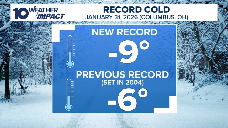
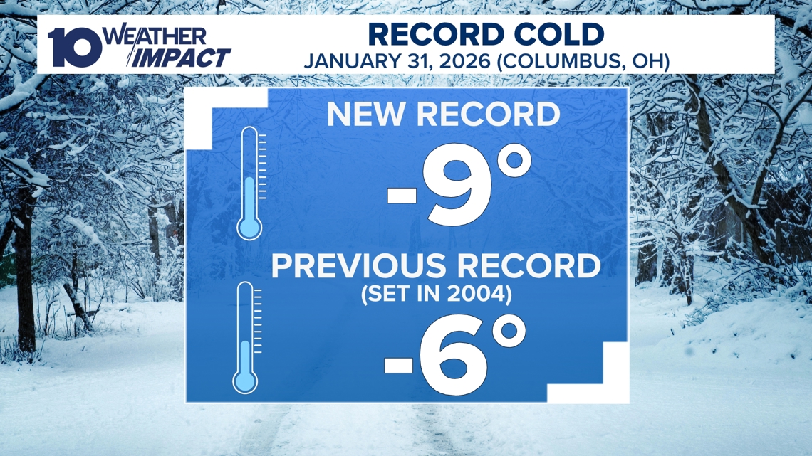
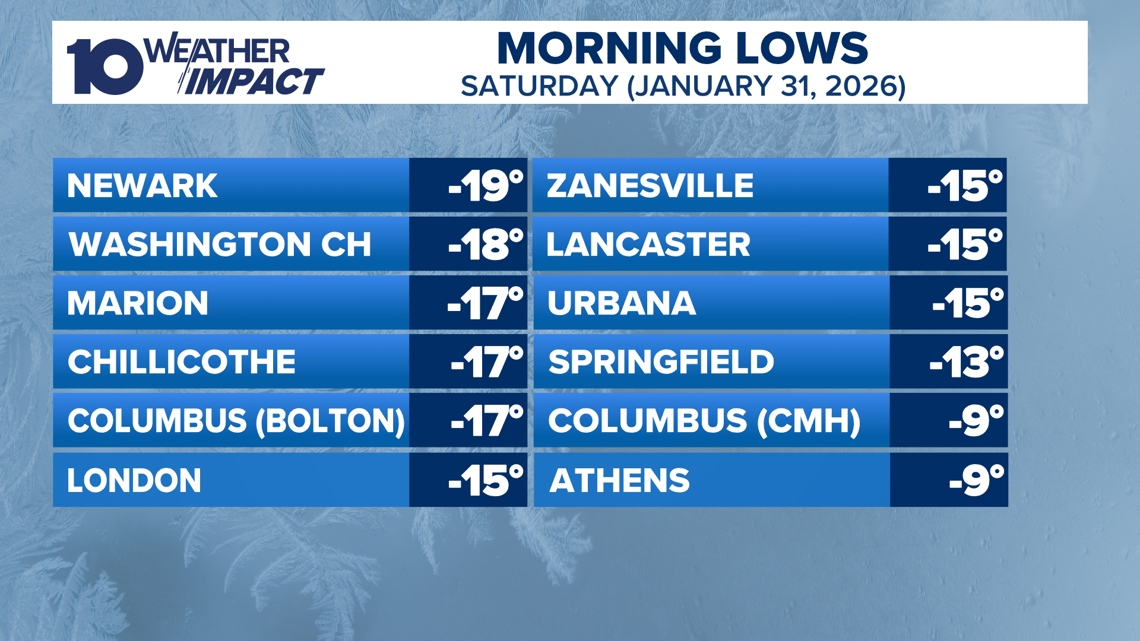
Record‑Breaking Low Temperature Across Central Ohio Columbus logged a historic –9°F at John Glenn Airport on Saturday morning, shattering the prior –6°F record set in 2004 [1][2][3]. Nearby stations reported temperatures ranging from –10°F to –19°F, with Newark reaching –19°F and wind chills plunging to –30°F [3]. Meteorologist Aaron White highlighted the widespread sub‑zero readings, noting that not all stations maintain complete historical records, but the consensus confirms an unprecedented cold spell [3].
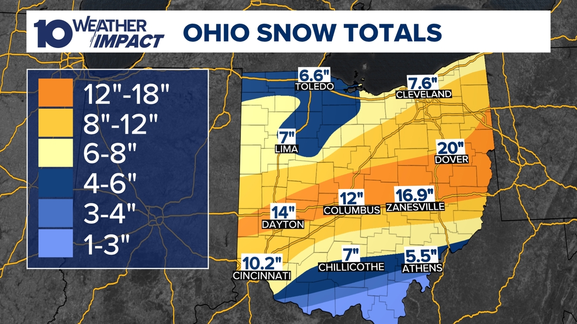
Snowpack Reaches 8‑16+ Inches Statewide Snow accumulations of eight to more than sixteen inches blanketed the entire state, with central Ohio reporting the deepest drifts [1][2]. The extensive snow cover reinforces the frigid air mass, limiting daytime warming and extending the deep freeze through the weekend [1][2]. Statewide snow reports posted on the station’s website detail the distribution and depth of the pack [1].
10 Weather Impact Alert Day Extended Through Sunday The 10 Weather Impact service prolonged its Alert Day into Sunday morning as temperatures lingered in the low single digits and wind chills intensified [1][2]. Hazardous‑condition warnings urged residents to limit outdoor exposure, protect plumbing, and keep emergency supplies ready [1][2]. The alert’s continuation underscores the severity of the cold and the agency’s active monitoring [1].
Arctic Air to Hold Temperatures Below 20°F Until Next Week A Canadian arctic air mass will keep daytime highs below the 20s for the remainder of the weekend, preventing any significant warmup until the following week [1][2]. Forecast models project gradual daytime highs rising into the 20s and near 30°F early next week, offering modest relief after the record cold [3]. Meteorologists caution that sub‑freezing temperatures will likely persist into mid‑February despite the upcoming trend [3].
Free 10TV+ Streaming Provides Continuous Updates Residents can follow live weather coverage and alerts via the free 10TV+ app on Roku and Amazon Fire TV, which streams 24/7 updates from the 10 Weather Impact team [1][2]. The platform offers on‑demand access to forecasts, snow‑accumulation maps, and safety advisories, ensuring the public stays informed throughout the deep freeze [1].
Sources
-
1.
WBNS:Columbus Endures Record Cold as Snowpack Persists, Warmer Weather Expected Next Week: Highlights the –9°F record, 8‑16+ inch snowpack, and a forecast of milder temperatures next week, emphasizing public safety alerts .
-
2.
WBNS:Columbus Record Low and Snowpack Keep Central Ohio in Deep Freeze: Mirrors the record low and extensive snow, focusing on the extended 10 Weather Impact Alert Day and the persistence of arctic air .
-
3.
WBNS:Columbus Sets New Record Low Temperature of –9°F: Provides detailed temperature readings across central and southern Ohio, wind‑chill values down to –30°F, and notes variability in station record‑keeping .
Timeline
2004 – Columbus previously holds its cold‑est January reading at –6°F, a benchmark that stands for 22 years until a new low shatters it in 2026 [3].
Jan 2026 – A strong arctic air mass surges south from Canada, setting the stage for an extreme cold spell across central Ohio and the Midwest [1].
Jan 24, 2026 (Saturday) – Columbus records a new all‑time low of –9°F, breaking the 2004 record; nearby stations plunge to the –10s and –19°F, with wind chills reaching –30°F, prompting urgent public warnings [3][1].
Jan 24‑25, 2026 – The 10 Weather Impact “Alert Day” is extended through Sunday as temperatures stay in the low single digits and wind chills intensify, urging residents to take hazardous‑condition precautions [1][2].
Jan 24‑26, 2026 – Snowfall blankets the entire state, with 8‑16+ inches reported across central Ohio, creating a deep snowpack that locks in the cold and delays any warming [1][2].
Jan 31, 2026 – Meteorologists forecast that temperatures will remain below 20°F through the weekend, but daytime highs should rise into the 20s‑30°F early next week, offering the first relief from the sub‑zero spell [3].
Feb 1, 2026 – The 10 Weather Impact team makes continuous updates available via the free 10TV+ streaming service on Roku and Amazon Fire TV, ensuring residents can monitor the evolving conditions [1][2].
Mid‑Feb 2026 – Forecast models still expect sub‑freezing temperatures through mid‑February, though the gradual warmup announced for early next week should moderate the extreme cold [3].
External resources (3 links)
- http://facebook.com/AaronWhiteTV/ (cited 1 times)
- http://instagram.com/aaronwhitetv/ (cited 1 times)
- http://x.com/AaronWhiteTV (cited 1 times)