Ohio Winter Storm Leaves Up to 20 Inches of Snow, Triggers Level 3 Emergencies
Updated (8 articles)
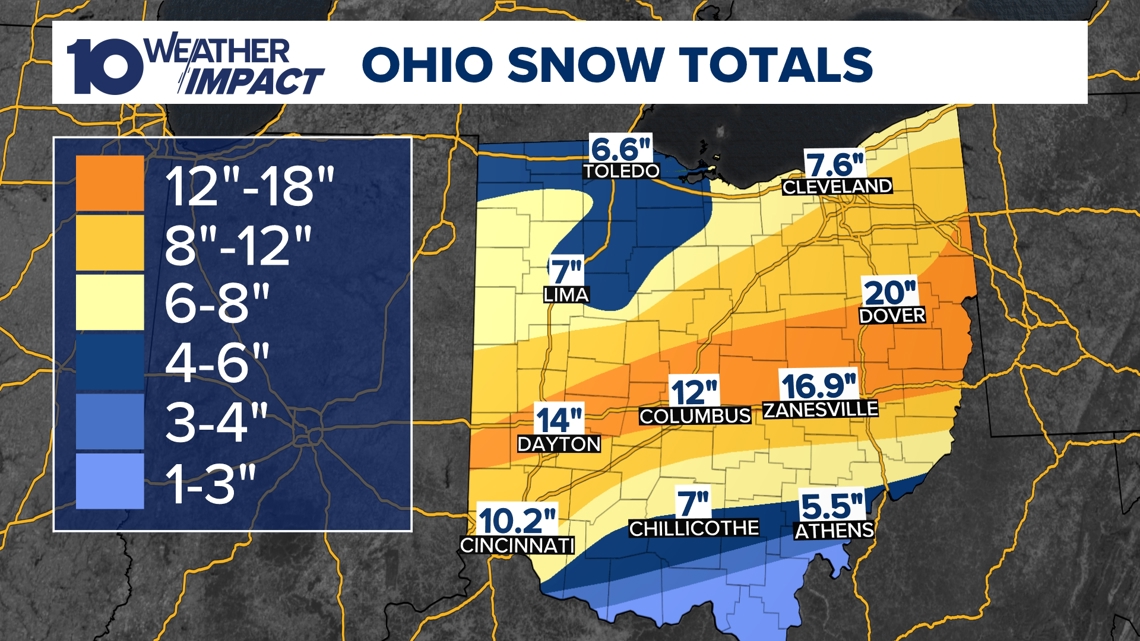
Storm timeline and snowfall totals The system moved across the central, southern and eastern United States beginning late Saturday night, intensified Sunday morning and ended late Sunday, dumping heavy snow across Ohio [2][3]. The highest official measurement was 20 inches in Dover, Tuscarawas County, while Zanesville recorded nearly 17 inches and Columbus‑area suburbs saw up to 13 inches [1][2]. Most of central Ohio received between 8 and 16 inches, with the Columbus metro averaging about a foot [1][4]. Snowfall totals are still being verified as viewers submit additional measurements [2].
Emergency declarations and road‑clearing response Franklin County was placed under a Level 2 Snow Emergency, restricting roads to emergency vehicles, while several southern counties were upgraded to Level 3, closing all non‑essential traffic [1][3][4]. The Ohio Department of Transportation mobilized more than 1,200 plow crews and 1,500 trucks staffed by roughly 3,000 workers on 12‑hour shifts to treat 43,000 lane miles [5][6][3]. Press secretary Matt Bruning posted real‑time updates on X, urging drivers to give crews space and consult municipal snow‑service maps [3][5]. The massive deployment aims to keep interstates passable despite ongoing subzero conditions [5][6].
School, business and community disruptions Tuesday classes were cancelled across the region, and many schools announced closures earlier in the week [1][2]. Numerous businesses shut down, and more than 100 churches canceled Sunday services, reflecting the storm’s broad impact on daily life [4][5]. Traffic conditions remained hazardous, with several highways briefly closed after vehicles became stuck, and authorities advised motorists to avoid non‑essential travel [3][4].
Extreme cold forecast and alerts Arctic air will drive morning temperatures into the single‑digit and subzero range, with wind chills projected between –10 °F and –20 °F through Monday and Tuesday [1][2][4]. A Weather Impact Alert for extreme cold was issued for at least a week, warning of heightened frostbite risk and reduced effectiveness of standard road salt [1][5][6]. Officials emphasized that chemical additives are needed for deicing at these temperatures, further complicating road‑clearance efforts [5][6].
Officials urge caution and preparedness Governor Mike DeWine and Columbus Mayor Andrew Ginther both briefed the public, urging residents to stay home, limit travel, and use shelter resources if needed [5][6]. Ohio State Highway Patrol Lieutenant Brice Nihiser highlighted unsafe speeds as the leading cause of weather‑related crashes and reiterated the call to give plow crews room [5][6]. The coordinated messaging underscores the seriousness of the combined snow and cold event.
Sources
-
1.
WBNS: Ohio Winter Storm Leaves Over 16 Inches of Snow and Triggers Snow Emergencies: Details 16+ inches in central Ohio, Level 2/3 emergencies, school cancellations, and subzero wind chills .
-
2.
WBNS: Central Ohio Receives Up to 20 Inches of Snow as Major Winter Storm Ends: Reports 20 inches in Dover, emergency levels, school and business closures, and a call for public snowfall reports .
-
3.
WBNS: Ohio Snowstorm Forces Road Closures and Massive Plow Deployment: Highlights hazardous roads, Level 2 emergency in Franklin County, deployment of over 1,200 ODOT crews, and real‑time updates from Matt Bruning .
-
4.
WBNS: Cars stuck on I‑70 West as snow intensifies, highways reopen: Describes vehicles stranded on I‑70, six‑inch snowfall early in the event, widespread church cancellations, and a statewide Winter Storm Warning .
-
5.
WBNS: Columbus Mayor Updates Residents Ahead of Major Winter Storm: Features Mayor Ginther’s briefing, Snow Warriors’ preparation for 8‑12 inches, ODOT’s 1,500‑truck deployment, and safety warnings from Lt. Nihiser .
-
6.
WBNS: DeWine and state officials urge caution as winter storm looms over central Ohio: Covers Governor DeWine’s stay‑home appeal, ODOT’s resources, 6‑12 inch snowfall forecast, and detailed cautions on salt effectiveness and driver behavior .
Timeline
Dec 2, 2025 – Columbus receives 3‑6 inches of snow, with more than 4 inches recorded in the city, prompting Level 2 and Level 3 snow emergencies and sub‑freezing temperatures, while forecasters note a new system moving toward the Ohio Valley [8].
Dec 13, 2025 – A winter storm drops 1‑9 inches across central Ohio, setting a new airport record of 5.4 inches at John Glenn International, placing counties under snow‑emergency levels and ushering single‑digit highs with wind chills below zero [7].
Jan 23, 2026 – Governor Mike DeWine urges Ohioans to stay home as a 6‑12‑inch snow event approaches, while ODOT readies 1,500 trucks and 3,000 workers with salt additives for sub‑zero conditions and stresses caution on icy roads [6].
Jan 24, 2026 – Mayor Andrew Ginther briefs residents on the impending storm, outlines the Snow Warriors’ plan to clear 8‑12 inches, announces a follow‑up briefing at 4 p.m., and cites ODOT’s deployment of 1,500 trucks and 3,000 drivers; OSHP Lt. Brice Nihiser warns drivers to slow down as wind chills dip to –5 to –15 °F [5].
Jan 25, 2026 – Six vehicles become stuck on I‑70 West near US 33 as snow falls, prompting a brief lane closure that reopens by 8:15 a.m.; six inches of snow accumulates, over 100 churches cancel services, and a Winter Storm Warning covers all 88 Ohio counties with forecasts of up to 16 inches and sub‑zero temps with –10 to –20 °F wind chills [4].
Jan 25, 2026 – Overnight snowfall creates hazardous roads across central Ohio; Franklin County enters a Level 2 emergency, ODOT deploys more than 1,200 plow crews, and press secretary Matt Bruning posts real‑time updates on X, while officials warn the storm could rank among the top five historic snow events if totals exceed 12 inches [3].
Jan 27, 2026 – Central Ohio receives up to 20 inches of snow, with a maximum of 20 inches in Dover, snow emergencies persist statewide, sub‑zero temperatures and wind chills of –10 to –20 °F extend through the week, and schools, businesses and travel face widespread disruptions; the public is urged to submit higher snowfall reports for verification [1].
Jan 27, 2026 – The storm leaves more than 16 inches of snow in parts of central Ohio, official winter‑storm warnings expire, Level 2 and Level 3 snow emergencies remain in effect, Zanesville records near 17 inches, Tuesday school classes are cancelled, and arctic air continues to drive wind chills to –10 to –20 °F [2].
All related articles (8 articles)
-
WBNS (Columbus, OH): Ohio Winter Storm Leaves Over 16 Inches of Snow and Triggers Snow Emergencies
-
WBNS (Columbus, OH): Central Ohio Receives Up to 20 Inches of Snow as Major Winter Storm Ends
-
WBNS (Columbus, OH): Ohio Snowstorm Forces Road Closures and Massive Plow Deployment
-
WBNS (Columbus, OH): Cars stuck on I‑70 West as snow intensifies, highways reopen
-
WBNS (Columbus, OH): Columbus Mayor Updates Residents Ahead of Major Winter Storm
-
WBNS (Columbus, OH): DeWine and state officials urge caution as winter storm looms over central Ohio
-
WBNS (Columbus, OH): Winter storm brings several inches of snow to central Ohio: Current snowfall totals
-
WBNS (Columbus, OH): Columbus, Ohio Receives 3‑6 Inches of Snow After Winter Storm
External resources (8 links)
- https://warriorwatch.columbus.gov/ (cited 2 times)
- https://twitter.com/hashtag/ODOTwinter?src=hash&ref_src=twsrc%5Etfw (cited 3 times)
- https://t.co/D3AfQbTt0n (cited 1 times)
- https://t.co/kZTfz0pmJJ (cited 1 times)
- https://t.co/y2mdfitzGi (cited 1 times)
- https://t.co/zE47OTcGJ2 (cited 1 times)
- https://portal.snowpaths.com/public/983278/983279 (cited 2 times)
- https://snowgo.dublin.oh.us/ (cited 1 times)