Puget Sound Faces Record‑Close Dry Spell as Warm Ridge Drives Snow Level Rise
Updated (18 articles)
14‑Day Dry Spell Near Record Ends With Tuesday Rain Seattle‑Tacoma International Airport logged 14 consecutive rain‑free days, one shy of the 15‑day record set in 1963, and meteorologists forecast light showers to begin Tuesday night, ending the streak as cloud cover spreads and temperatures climb into the upper 40s °F and low 50s °F [3].
High‑Pressure Ridge Pushes Temperatures 10‑15°F Above Normal strengthening ridge will keep Puget Sound partly cloudy and dry Tuesday through Friday, with highs in the upper 50s to around 60 °F and lows in the low‑ to mid‑40s °F; Seattle is expected to hit 63 °F on Tuesday and Wednesday, matching early‑spring warmth [1].
Snow Levels Drop to 4,000 ft, Yielding Limited Mountain Snowfall Snow‑level forecasts show 5,500 ft on Saturday, 4,500 ft Sunday, and a dip to roughly 4,000 ft early Monday before rising again, producing 2‑5 inches of snow at higher elevations and isolated higher totals, while coastal rain totals remain modest [1].
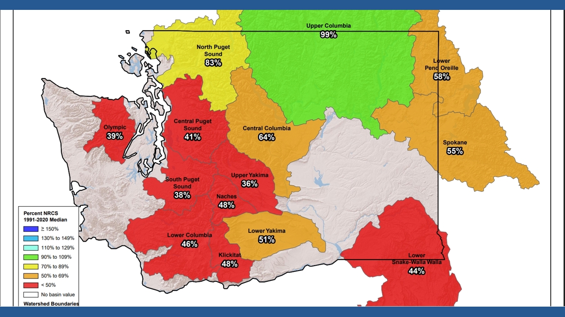
Cascade Snowpack Remains Well Below Seasonal Norms Despite 2‑4 inches of fresh snow at passes such as Stevens and Snoqualmie, the overall snowpack stays far below normal; Oregon’s statewide snowpack ranks second‑lowest since 1981, SNOTEL stations record deep deficits in central and southern Cascades, and the shortfall threatens Washington’s spring streamflow [2].
Warm Moisture May Hinder Snowpack Recovery The incoming southwest moisture that will bring Tuesday rain is warmer than typical Gulf‑of‑Alaska systems, raising concerns that additional precipitation will fall as rain rather than snow, limiting the modest snowfall’s ability to close the existing snowpack deficit [3][2].
Sources
-
1.
King5: Unseasonably Warm Week Ahead for Puget Sound Amid Dropping Snow Levels: details forecast of record‑high temperatures, snow‑level drops to 4,000 ft, modest rain, and potential limited coastal flooding .
-
2.
King5: Cascade Mountains Snowpack Lags Behind Recent Snowfall: reports snowpack far below normal despite recent snowfall, Oregon’s second‑lowest snowpack since 1981, SNOTEL deficits, and water‑resource concerns .
-
3.
King5: Seattle’s 14‑Day Dry Spell Nears Record as Rain Returns Tuesday: describes the 14‑day rainless streak, impending Tuesday showers, rising temperatures, warm southwest moisture, and its impact on snow levels and snowpack .
Timeline
Nov 28, 2025 – A ridge of high pressure over the Gulf of Alaska holds a dry pattern across western Washington through the Thanksgiving weekend, bringing partly sunny skies, low‑50s highs and snow levels near 4,000‑5,000 ft[18].
Dec 16, 2025 – The National Weather Service issues the sixth Blizzard Warning in its history for the Cascades, warning of snow above 2,000 ft and wind gusts up to 45 mph, and notes that Highway 2 over Stevens Pass closes due to slides[17].
Dec 17, 2025 – Winds ease and a cooler, more seasonal pattern settles over western Washington, dropping snow levels and delivering 5‑10 inches of snow at Snoqualmie and Stevens Pass while an atmospheric river brushes central Oregon[16].
Dec 19, 2025 – The NWS issues winter‑storm warnings for Washington, Oregon, Idaho, Montana and Wyoming, forecasting up to three feet of snow, strong winds and blowing snow through Saturday[3].
Dec 19, 2025 – Warm weather leaves the West with well‑below‑average snowpack; Lake Tahoe resorts run limited lifts and Utah’s Midway Ice Castles are postponed, while the Deschutes Basin records its slowest snow start since 1981[4].
Dec 19, 2025 – Climate scientists warn that the thin snowpack threatens water supplies, linking the drought to rising demand and hotter conditions in the Colorado River Basin[1].
Dec 20, 2025 – Heavy mountain snow falls across the Cascades, with Stevens Pass topping 18 inches and forecasts of 2‑3 feet at Mount Baker by Tuesday, prompting travel advisories for Sunday night[14].
Dec 26, 2025 – A Winter Weather Advisory warns that snow levels will drop to about 2,500 ft and 6‑12 inches of snow could fall on Cascade passes, urging travelers to carry emergency kits and check road conditions[13].
Dec 27, 2025 – Light snow lingers in a Puget Sound convergence zone, dropping up to 2 inches in Snohomish and King counties, while the ridge keeps the broader pattern dry and nights plunge into the low‑30s[12].
Dec 27, 2025 – Officials caution that post‑Christmas mountain‑pass travel could be “very difficult to impossible” as snow levels fall and 6‑12 inches accumulate across the Cascades, recommending emergency‑kit items such as flashlights, blankets and tire chains[13].
Dec 31, 2025 – A high‑pressure ridge leaves New Year’s Eve dry across western Washington, allowing celebrations without rain; Sea‑Tac logs 8.37 inches of rain for December, about 3 inches above average[11].
Jan 5, 2026 – The NWS issues a Winter Storm Warning for the Cascades, projecting 2‑4 feet of snow from Tuesday to Thursday, rain of 0.5‑1 inch across Puget Sound, and wind gusts up to 50 mph on islands, while the Northwest Avalanche Center raises danger to “considerable or high” above 5,500 ft[10].
Jan 6, 2026 – The NWS expands winter‑storm warnings to Washington, Oregon, Alaska, Idaho and Montana, warning that travel “could be very difficult to impossible” and urging motorists to delay travel and carry emergency supplies[2].
Jan 8, 2026 – A colder system pushes snow levels down to 500 ft overnight in western Washington, creating a brief rain‑snow mix at sea level and adding 2‑4 feet of snow to the Cascades under an ongoing Winter Storm Warning[9].
Jan 9, 2026 – Scientists declare a snow drought across the western U.S., noting record‑low snowpack, a persistent ridge keeping storms away, and concerns that the 2034 Winter Olympics in Salt Lake City may face “weak snowpack” challenges[1].
Jan 9, 2026 – The Sierra Nevada finally receives heavy snow only after atmospheric‑river storms break the ridge, while the rest of the West remains in drought, heightening risk to the Colorado River Basin’s water supplies[1].
Jan 15, 2026 – A high‑pressure ridge continues to produce a dry spell across western Washington, with record‑tying 58 °F in Seattle and snow levels hovering near 12,000 ft; forecasters expect the next meaningful rain only late next week[8].
Jan 27, 2026 – Seattle‑Tacoma International Airport logs 14 consecutive rain‑free days, “one day short of the 15‑day record set in 1963,” and meteorologists forecast showers to arrive Tuesday night, potentially ending the streak[7].
Jan 29, 2026 – New snowfall adds only modest gains to the Cascades, with Stevens Pass gaining 2‑3 inches and Oregon’s snowpack at its second‑lowest level since 1981, leaving spring streamflow concerns for Washington[6].
Feb 3, 2026 – The forecast calls for an unseasonably warm week in Puget Sound, with highs in the low‑60s, a record‑high 63 °F in Seattle, and a strong ridge driving temperatures 10‑15 °F above normal; a weak La Niña pattern, which “has never produced a snow‑free La Niña season in Seattle,” normally brings cooler, wetter winters[5].
2026‑2034 (future) – Utah officials warn that recurring weak snowpacks could complicate preparations for the 2034 Winter Olympics in Salt Lake City, where December recorded one of its latest measurable snowfalls on record, underscoring the vulnerability of winter‑hosted events to climate variability[1].
Dive deeper (4 sub-stories)
-
Unseasonably Warm Week Hits Puget Sound as Snow Levels Plummet and Rain Returns
(5 articles)
-
Recent Snowfall Fails to Close Cascade Snowpack Deficit, Record Low Persists
(7 articles)
-
Western U.S. Snow Drought Deepens, Threatening Water Supplies and 2034 Olympics
(3 articles)
-
Snow Levels Drop to 500 Feet, Prompting Lowland Wet Snow and Mountain Accumulation
(3 articles)
All related articles (18 articles)
-
King5 (Seattle, WA): Unseasonably Warm Week Ahead for Puget Sound Amid Dropping Snow Levels
-
King5 (Seattle, WA): Cascade Mountains Snowpack Lags Behind Recent Snowfall
-
King5 (Seattle, WA): Seattle’s 14‑Day Dry Spell Nears Record as Rain Returns Tuesday
-
King5 (Seattle, WA): Extended dry weather persists across western Washington through weekend
-
CNN: The western US is in a snow drought, raising fears for summer water supplies
-
King5 (Seattle, WA): Snow levels fall overnight across western Washington, raising chance of lowland wet snow and slick roads
-
King5 (Seattle, WA): National Weather Service issues Winter Storm Warning as heavy snow and high winds head for the Cascades
-
Newsweek: NWS issues winter-storm warnings for five states as up to 35 inches of snow and high winds are forecast
-
King5 (Seattle, WA): Dry New Year’s Eve ends rain; showers expected on New Year’s Day in Western Washington
-
King5 (Seattle, WA): Western Washington sees light snow, then dry stretch with freezing nights ahead
-
King5 (Seattle, WA): Snow could complicate post-Christmas mountain pass travel in Washington
-
King5 (Seattle, WA): Heavy mountain snow continues toward Christmas across Cascades, with up to 2–3 feet possible at some passes
-
King5 (Seattle, WA): Warm weather and low snowpack disrupt Western ski resorts
-
AP: Warm weather and low snowpack slow Western ski resorts
-
Newsweek: Winter storm warnings issued for five states with up to three feet of snow through Saturday
-
King5 (Seattle, WA): Blustery weather eases in western Washington
-
King5 (Seattle, WA): Blizzard Warning issued for Olympics, Cascades
-
King5 (Seattle, WA): Dry Weather Expected Over Holiday Weekend, With Spotty Showers Possible
External resources (19 links)
- https://forecast.weather.gov/wwamap/wwatxtget.php?cwa=usa&wwa=Winter%20Storm%20Warning (cited 6 times)
- https://nwcc-apps.sc.egov.usda.gov/imap/#version=2&elements=&networks=!&states=!&basins=!&hucs=&minElevation=&maxElevation=&elementSelectType=any&activeOnly=true&activeForecastPointsOnly=true&hucLabels=false&hucIdLabels=false&hucParameterLabels=true&stationLabels=&overlays=&hucOverlays=state&basinOpacity=100&basinNoDataOpacity=100&basemapOpacity=100&maskOpacity=0&mode=data&openSections=dataElement,parameter,date,basin,options,elements,location,networks,baseMaps,overlays,labels&controlsOpen=true&popup=&popupMulti=&popupBasin=&base=esriWgc&displayType=basin&basinType=6&dataElement=SNWD&depth=-8¶meter=PCTPORMED&frequency=MONTHLY&duration=I&customDuration=&dayPart=E&monthPart=E&forecastPubDay=1&forecastExceedance=50&useMixedPast=true&seqColor=2&divColor=7&scaleType=D&scaleMin=&scaleMax=&referencePeriodType=POR&referenceBegin=1991&referenceEnd=2020&minimumYears=20&hucAssociations=true&relativeDate=-1&lat=41.305&lon=-112.429&zoom=5.5 (cited 2 times)
- https://wsdot.com/travel/real-time/mountainpasses/Blewett (cited 2 times)
- https://wsdot.com/travel/real-time/mountainpasses/Cayuse (cited 2 times)
- https://wsdot.com/travel/real-time/mountainpasses/Chinook (cited 2 times)
- https://wsdot.com/travel/real-time/mountainpasses/Crystal-to-Greenwater (cited 2 times)
- https://wsdot.com/travel/real-time/mountainpasses/Mt.-Baker (cited 2 times)
- https://wsdot.com/travel/real-time/mountainpasses/North-Cascade-Hwy (cited 2 times)
- https://wsdot.com/travel/real-time/mountainpasses/Snoqualmie (cited 2 times)
- https://wsdot.com/travel/real-time/mountainpasses/Stevens (cited 2 times)
- https://wsdot.com/travel/real-time/mountainpasses/White (cited 2 times)
- https://forecast.weather.gov/showsigwx.php?warnzone=WAZ310&warncounty=WAC073&firewxzone=WAZ656&local_place1=4%2520Miles%2520NE%2520Bellingham%2520International%2520Airport%2520WA&product1=Wind+Advisory&lat=48.8243&lon=-122.4718 (cited 1 times)
- https://forecast.weather.gov/wwamap/wwatxtget.php?cwa=SEW&wwa=winter%2520storm%2520warning (cited 1 times)
- https://forecast.weather.gov/wwamap/wwatxtget.php?cwa=SEW&wwa=winter%2520weather%2520advisory (cited 1 times)
- https://nwcc-apps.sc.egov.usda.gov/imap/#version=169&elements=&networks=!MSNT&states=!&basins=!&hucs=&minElevation=&maxElevation=&elementSelectType=any&activeOnly=true&activeForecastPointsOnly=false&hucLabels=true&hucIdLabels=false&hucParameterLabels=true&stationLabels=&overlays=&hucOverlays=state&basinOpacity=75&basinNoDataOpacity=0&basemapOpacity=100&maskOpacity=100&mode=data&openSections=dataElement,parameter,date,basin,options,elements,location,networks,baseMaps,overlays,labels&controlsOpen=true&popup=&popupMulti=&popupBasin=&base=esriWsr&displayType=basin&basinType=wa_8&dataElement=WTEQ&depth=-8¶meter=PCTMED&frequency=DAILY&duration=I&customDuration=&dayPart=E&monthPart=B&forecastPubDay=1&forecastExceedance=50&useMixedPast=true&seqColor=1&divColor=7&scaleType=D&scaleMin=&scaleMax=&referencePeriodType=fixed&referenceBegin=1991&referenceEnd=2020&minimumYears=20&hucAssociations=true&relativeDate=-1&lat=48.124&lon=-120.914&zoom=6.9&autoExport=full,pdf,2,2,L,BL,Washington%2520SNOTEL,49.4893,44.9175,-114.8615,-125.2705 (cited 1 times)
- https://wsdot.wa.gov/travel (cited 1 times)
- https://www.cpc.ncep.noaa.gov/products/predictions/long_range/lead14/ (cited 1 times)
- https://www.wsdot.com/traffic/passes/ (cited 1 times)
- https://nwac.us/avalanche-forecast/#/all/ (cited 1 times)