Dense Fog Advisory Issued for Central Ohio Tuesday Amid Warm‑Front Forecast
Updated (11 articles)
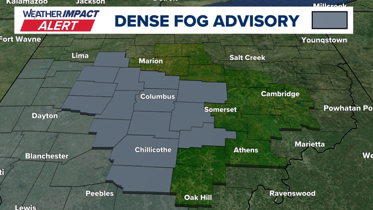
Fog Advisory and Visibility Limits Prompt Immediate Alerts The National Weather Service released a Dense Fog Advisory for central Ohio counties on Tuesday morning, warning that visibility would drop to a quarter‑mile or less and triggering a 10TV Weather Impact Alert Day for hazardous travel conditions [1].
Meteorological Conditions Produce Back‑to‑Back Fog Events Forecasters attribute Tuesday’s thinner fog to cold, moisture‑laden soil from recent snowmelt meeting an influx of warmer air, while overnight temperatures fell to the mid‑upper 30s, leaving roads wet and slick [1].
Travel and Community Resources Highlighted for Residents The alert urged commuters to exercise caution, and the station provided links to school‑closing notices, interactive radar, active alerts, and a 10‑day forecast to help the public navigate the reduced‑visibility conditions [1].
Warm Storm and Cooling Front Expected Later This Week Over the next several days a windy storm system is forecast to bring near‑record heat (up to 66 °F, matching 2017), scattered rain showers Wednesday‑Thursday, a possible thunderstorm Thursday, followed by a cold front on Friday and snow showers on Sunday [1].
Timeline
Dec 5, 2025 – Ohio records wind‑chill values lower than any previous reading for the season, with ambient temperatures in the single digits and teens amplified by strong winds; forecasters expect a modest warm‑up into the 20s‑30s by afternoon and a wintry front on Sunday that could bring rain and snow [11].
Dec 9, 2025 – A 10TV Weather Impact Alert Day warns that a strong storm system will bring a rain‑snow mix Wednesday morning, minimal snow accumulations near freezing, and gusts up to 40 mph, while a weaker system looms for Friday‑Saturday [10].
Dec 14, 2025 – Saturday’s snowfall peaks at up to 9 inches across central Ohio, accompanied by 25 mph winds, blowing snow, and wind chills near or below zero; several counties declare snow emergencies and the NWS issues Cold Weather Advisories [9].
Dec 27, 2025 – A powerful low‑pressure system drives 40‑45 + mph wind gusts statewide on Monday, prompting a Wind Advisory, rapid temperature drops into the low 20s, and warnings of downed limbs and possible power outages [7].
Dec 28, 2025 – A developing storm moves into central Ohio Sunday night, bringing rain and thunderstorms with a Level 1 severe‑weather risk and gusts near 60 mph; a sharp 40‑degree temperature plunge to the 20s by Monday noon creates flash‑freeze hazards on wet roads [8].
Dec 31, 2025 – Snowfall of 1‑3 inches begins after 4 p.m., triggering a Weather Impact Alert for OSU game travel and New Year’s Eve celebrations; wind chills stay in the teens, highs remain in the 20s, and the 10TV+ app offers real‑time radar tracking [6].
Jan 1, 2026 – A Weather Impact Alert Day warns of up to 2 inches of snow through early evening, with most areas seeing 0.5‑1.5 inches, breezy winds, and wind chills in the teens; the alert coordinates travel for the OSU game and New Year’s Eve plans [5].
Jan 11, 2026 – Light snow showers drift in overnight into Sunday, delivering dustings up to a half inch while strong winds drive wind chills into the 10s‑20s; roads become slick despite initial warmth, and sunshine returns Monday‑Tuesday with highs in the 40s [4].
Jan 20, 2026 – A Winter Storm Watch covers six southern Ohio counties from Saturday 7 a.m. to Monday 7 a.m., forecasting subzero wind chills, possible snow, and the heaviest impacts Friday night into Saturday with wind chills of ‑5 to ‑15 °F [3].
Jan 21, 2026 – The 10 Weather Impact Team issues Alert Days for Friday evening through Monday morning, highlighting dangerous wind‑chill values, uncertain snow amounts, and the expectation that the worst wind‑chill conditions occur Friday night into early Saturday [3].
Feb 2, 2026 – Snow returns Friday with 1‑3 inches across central Ohio, including isolated 4.5‑inch totals; bitter cold and subzero wind chills persist Saturday, but advisories end, and a brief warm‑up on Sunday brings a new snow band of 1‑2 inches [2].
Feb 7, 2026 – Forecasts call for gradual warming into the 30s‑40s on Monday and Tuesday, scattered rain showers Wednesday‑Thursday, a possible thunderstorm Thursday, and a cold front Friday that clears skies before Sunday’s snow showers [2].
Feb 17, 2026 – The National Weather Service issues a Dense Fog Advisory for central Ohio Tuesday, reducing visibility to a quarter‑mile; forecasters attribute the fog to cold, moisture‑laden soil meeting warm air, and warn of a warm storm later in the week with near‑record 66 °F heat, rain showers Wednesday‑Thursday, a thunderstorm Thursday, and a cooling front Friday [1].
Dive deeper (9 sub-stories)
-
WBNS (Columbus, OH): Dense Fog Advisory Triggers Weather Impact Alert for Central Ohio Tuesday
-
Snow Returns to Central Ohio Friday, Cold Lingers as Forecast Predicts Gradual Warm‑Up
(2 articles)
-
WBNS (Columbus, OH): Central Ohio braces for weekend snow and subzero wind chills as arctic blast returns
-
WBNS (Columbus, OH): Snow showers expected in central Ohio overnight into Sunday as cold air moves in
-
Central Ohio Braces for Up to Two Inches of Snow as Weather Impact Alert Day Begins
(2 articles)
-
WBNS (Columbus, OH): Central Ohio braces for 40-50 mph wind gusts Monday as a strong low pressure system moves through
-
WBNS (Columbus, OH): Storm system may bring thunderstorms to central Ohio overnight
-
WBNS (Columbus, OH): Rain, snow and wind impacting Wednesday morning commute in central Ohio
-
WBNS (Columbus, OH): Ohio Experiences Record Low Wind Chills on Friday Morning
All related articles (11 articles)
-
WBNS (Columbus, OH): Dense Fog Advisory Triggers Weather Impact Alert for Central Ohio Tuesday
-
WBNS (Columbus, OH): Snow Returns to Central Ohio as Bitter Cold Lingers, Forecast Calls for Gradual Warm‑up
-
WBNS (Columbus, OH): Central Ohio braces for weekend snow and subzero wind chills as arctic blast returns
-
WBNS (Columbus, OH): Snow showers expected in central Ohio overnight into Sunday as cold air moves in
-
WBNS (Columbus, OH): Central Ohio braces for up to 2 inches of snow as Weather Impact Alert Day is issued
-
WBNS (Columbus, OH): Snow expected this evening across central and southern Ohio with 1-3 inches of accumulation
-
WBNS (Columbus, OH): Central Ohio braces for 40-50 mph wind gusts Monday as a strong low pressure system moves through
-
WBNS (Columbus, OH): Storm system may bring thunderstorms to central Ohio overnight
-
WBNS (Columbus, OH): Sub-zero wind chills Sunday & Monday after heavy snow Saturday
-
WBNS (Columbus, OH): Rain, snow and wind impacting Wednesday morning commute in central Ohio
-
WBNS (Columbus, OH): Ohio Experiences Record Low Wind Chills on Friday Morning
External resources (3 links)
- http://facebook.com/AaronWhiteTV/ (cited 1 times)
- http://instagram.com/aaronwhitetv/ (cited 1 times)
- http://x.com/AaronWhiteTV (cited 1 times)