Snow Returns to Central Ohio Sunday With Light Accumulations, Black‑Ice Threat
Updated (50 articles)
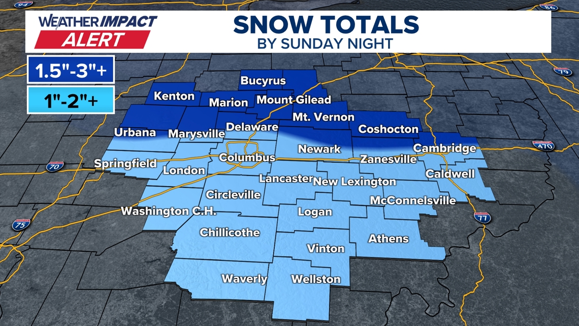
Snow Returns Sunday After Recent Storm System 10 Weather Impact Alert warns that scattered snow showers will blanket central Ohio on Sunday, with accumulations ranging from a dusting to two inches, about an inch in Columbus and up to two inches in the heaviest bands [1]. Daytime highs rise into the mid‑30s, causing some snow to melt and create wet surfaces, while overnight lows dip into the 20s, setting up black‑ice conditions for Monday commuters [1]. Travel impacts are expected on roads north of I‑70, where snowfall is slightly heavier, and the alert will remain active through the event [1].
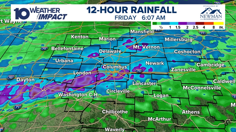
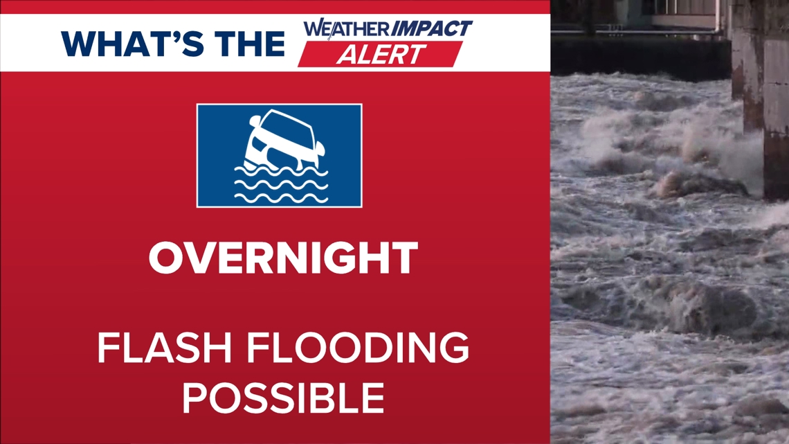
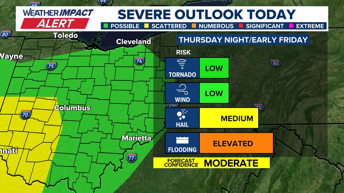
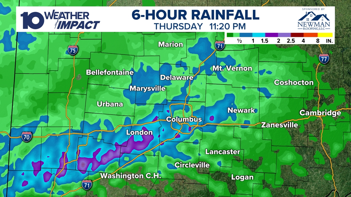
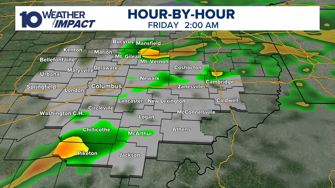
Thursday Night Storm Delivered Over Two Inches Rain moist air mass pushed a strong storm system into central Ohio Thursday night, spawning intense showers and thunderstorms that produced radar‑estimated rainfall exceeding two inches in several locations by 11:20 p.m. [3][4]. The system’s heavy rain shifted the primary hazard from wind and hail to flash flooding, prompting a 10TV Weather Impact Alert Day that stayed in effect through the night [3][4]. Fayette and Madison counties faced alerts until 2 a.m., and the storm began to wane before sunrise Friday [3][4].
Flash Flooding and Wind Threats Followed Rainfall Rain totals topped 1.5 inches in many areas, with Newark recording 1.76 inches and Columbus 1.68 inches, leading to street flooding and minor flood stage on Raccoon Creek near Granville [2]. A strong cold front ushered wind gusts over 40 mph and a sharp temperature drop on Friday, further complicating travel and increasing the risk of hazardous conditions [2]. Officials encouraged residents to submit local rainfall reports to improve real‑time tracking [2].
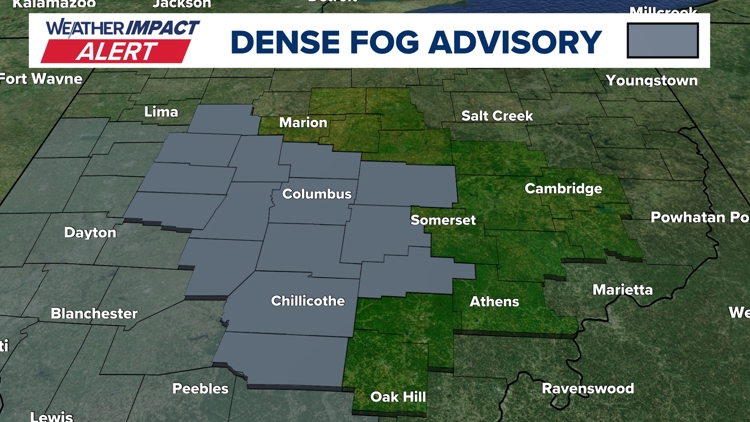
Fog Preceded Storm, Reducing Visibility Dense fog returned Tuesday, prompting a Weather Impact Alert and a National Weather Service Dense Fog Advisory that reduced visibility to a quarter‑mile or less across central Ohio [5]. Forecasters linked the fog to saturated soils from recent snowmelt meeting warmer air, creating slick, wet road surfaces after overnight lows fell into the mid‑upper 30s [5]. The advisory noted an upcoming warm storm, scattered rain Wednesday‑Thursday, a cooling front Friday, and the possibility of snow showers on Sunday [5].
Overall Pattern Shifts From Fog to Rain to Snow Central Ohio experienced a rapid sequence of weather events: dense fog on Tuesday, a severe‑weather‑level storm with heavy rain and flash flooding on Thursday‑Friday, followed by a brief dry spell and snow showers on Sunday [5][2][3][1]. The marginal level‑1 severe‑weather risk included an isolated tornado possibility, though the primary impacts were rainfall‑related flooding and later slippery snow‑covered roads [3][4]. Temperatures are expected to climb back into the 40s by mid‑next week after the brief cold snap, ending the immediate threat cycle [1].
Sources
-
1.
WBNS: Snow Returns to Central Ohio Sunday with Light Accumulations: Details the 10 Weather Impact Alert, expected snow totals, melt‑day temperatures, and black‑ice risk for Monday .
-
2.
WBNS: Heavy Rainfall Triggers Flash Floods and Minor River Rises in Ohio: Reports 2‑plus inches of rain, flash‑flood totals in Newark and Columbus, Raccoon Creek’s minor flood stage, and post‑rain wind gusts .
-
3.
WBNS: Strong Storm System Brings Severe Weather and Flood Risk to Central Ohio: Describes the Thursday night storm entry, shift from wind/hail to flooding, marginal severe‑weather risk, and rainfall exceeding two inches .
-
4.
WBNS: Strong Storm System Moves Through Central Ohio Thursday Night: Mirrors the previous report, emphasizing the timing of thunderstorms, county alerts, and the transition to flash‑flood concerns .
-
5.
WBNS: Dense Fog Advisory Triggers Weather Impact Alert for Central Ohio Tuesday: Covers the fog advisory, visibility impacts, meteorological causes, and the forecasted progression to rain, a cold front, and Sunday snow showers .
Related Tickers
Timeline
Dec 2, 2025 – Central Ohio receives 3‑6 inches of snow, with Columbus recording over 4 inches; Level 2 and Level 3 snow emergencies restrict travel, and temperatures stay below freezing for the week [26].
Dec 2, 2025 – Snowfall of 3‑5 inches spreads across the region, Worthington sees more than 6 inches, prompting road hazards and school cancellations; winter‑weather advisories lift as the system moves out [27].
Dec 2, 2025 – Columbus City Schools cancel all Tuesday classes after overnight snow creates slippery roads, joining other districts in regional closures [28].
Dec 2, 2025 – Central Ohio schools, courts and colleges close Tuesday due to snow; Franklin County courts shut, and snow‑emergency levels range from Level 1 to Level 3 [29][30].
Dec 5, 2025 – Record‑low wind chills hit Ohio, with temperatures in the single digits and teens amplified by strong winds, prompting warnings for outdoor exposure [25].
Dec 15, 2025 – More than a dozen central Ohio school districts close or delay on Tuesday because of several inches of snow and wind chills as low as –20 °F; rain is forecast for Thursday [24].
Dec 28, 2025 – A storm system brings rain and thunderstorms Sunday night into Monday, with a Level 1 severe‑weather risk and a cold front expected to cause a flash‑freeze and slippery roads Monday morning [23].
Dec 31, 2025 – A Weather Impact Alert warns of 1‑3 inches of snow after 4 p.m., breezy winds and teen‑degree wind chills, and advises travelers heading to an OSU game and New Year’s Eve events [22].
Jan 1, 2026 – A Weather Impact Alert Day predicts up to 2 inches of snow (0.5‑1.5 inches typical) and wind chills in the teens, aiming to protect OSU game‑goers and New Year’s Eve planners [21].
Jan 11, 2026 – Light snow showers bring up to a half‑inch of accumulation overnight into Sunday, with wind chills in the 10s‑20s; sunshine returns with 40 °F highs on Monday and Tuesday [20].
Jan 16, 2026 – The Columbus Metropolitan Library opens its main branch as a cold‑weather shelter Monday, offering Wi‑Fi and restrooms while all other branches close for MLK Day; temperatures may dip to 3 °F with wind chills –5 to –15 °F [19].
Jan 24, 2026 – Mayor Andrew Ginther briefs residents on an approaching major winter storm, noting the Snow Warriors will clear 8‑12 inches, a Winter Storm Warning is in effect, wind chills could reach –5 to –15 °F, and ODOT deploys 1,500 trucks and 3,000 drivers for road treatment [18].
Jan 25, 2026 – Giant Eagle shuts all Ohio stores at 4 p.m. Sunday as six to twelve inches of snow fall and every central Ohio county enters a Level 2 or Level 3 snow emergency, with bitter cold expected for the rest of the week [16].
Jan 25, 2026 – Ohio ODOT mobilizes over 1,200 plow crews, places Franklin County under a Level 2 Snow Emergency, and posts real‑time updates as 8‑14 inches of snow threaten central Ohio roads [17].
Jan 25, 2026 – Ohio State cancels Monday and Tuesday in‑person classes after the storm drops more than 16 inches of snow, forecasts subzero temperatures and wind chills of –10 °F to –20 °F, and urges students to use the emergency website for updates [15].
Jan 26, 2026 – The Columbus Blue Jackets postpone their Monday night game versus the Los Angeles Kings to March 9 after a foot of snow and extreme cold make travel unsafe; the team’s next home game moves up to Wednesday against the Flyers [13].
Jan 26, 2026 – Central Ohio districts announce Monday closures as a historic winter storm delivers over 16 inches of snow, subzero temperatures persist, and a Weather Impact Alert for extreme cold covers the seven‑day forecast [14].
Jan 26, 2026 – Level 2 Snow Emergencies cover most central Ohio counties; the Columbus Zoo remains closed through Jan. 30, courts close Tuesday, and the storm ranks as the fifth‑largest on record for Columbus, prompting widespread cancellations [11].
Jan 27, 2026 – Multiple central Ohio districts close schools Tuesday, reporting 8‑16 inches of snow and wind chills near –20 °F; Weather Impact Alerts continue through the week as subzero temps linger [12].
Jan 27, 2026 – Central Ohio schools close Wednesday amid a deep freeze, with snow totals of 8‑16+ inches, subzero temperatures, and alerts issued for every morning through Sunday [9].
Jan 27, 2026 – Dover records a maximum of 20 inches of snow, the highest in the storm, prompting snow emergencies, subzero temps, and disruptions to schools, businesses and travel across the region [10].
Jan 28, 2026 – The Columbus Zoo remains closed through Feb. 1 after the record‑breaking storm drops more than 16 inches of snow, the fifth‑largest in city history, and subzero wind chills continue [8].
Jan 29, 2026 – Central Ohio schools shut down Friday as arctic air drives subzero wind chills, with forecasts of a possible –6 °F record low on Saturday and wind chills near –20 °F; Sunday sees a gradual warm‑up [7].
Feb 2, 2026 – Snow returns Friday with 1‑3 inches across central Ohio, bitter cold and sub‑zero wind chills persist Saturday, and a gradual warm‑up to the 30s‑40s is expected early next week [6].
Feb 17, 2026 – A dense fog advisory triggers a Weather Impact Alert for Tuesday morning as fog reduces visibility to a quarter‑mile; the fog results from cold, moisture‑laden soil meeting warmer air, and a warm storm with near‑record heat is forecast later in the week [5].
Feb 20, 2026 – Heavy rain Thursday‑Friday produces flash flooding with rainfall exceeding 2 inches in many locations, Raccoon Creek reaches minor flood stage, and a strong cold front brings wind gusts over 40 mph and a temperature drop [2].
Feb 20, 2026 – A strong storm system moves into central Ohio Thursday night, prompting a 10TV Weather Impact Alert Day, shifting risk from wind/hail to heavy rain and flash flooding, with rainfall totals topping 2 inches and storms expected to wane by sunrise Friday [3][4].
Feb 22, 2026 – Snow returns to central Ohio on Sunday with light accumulations of up to two inches, especially north of I‑70; daytime highs rise to the mid‑30s while overnight lows in the 20s risk black ice for Monday’s commute, and warmer weather returns by mid‑next week [1].
Future/Planned events
Mar 9, 2026 – The postponed Columbus Blue Jackets game against the Los Angeles Kings is rescheduled for March 9 (time TBD) [13].
Mid‑Feb 2026 – Temperatures are projected to climb back into the 40s by mid‑next week, ending the cold snap that began in late January [1].
Mid‑week Feb 2026 – A next period of rain is expected mid‑next week after the Sunday snow event [2].
Dive deeper (9 sub-stories)
-
Snow Returns Sunday to Central Ohio After Heavy Rain, Flooding, and Fog
(14 articles)
-
WBNS (Columbus, OH): Heavy Rainfall Triggers Flash Floods and Minor River Rises in Ohio
-
Central Ohio Schools Set to Reopen Monday After Record Snowstorm and Arctic Freeze
(17 articles)
-
WBNS (Columbus, OH): Central Ohio Schools Remain Closed as Winter Storm Extends to Fifth Day
-
Columbus Zoo Extends Shutdown to Feb. 1 After Record Snowstorm
(3 articles)
-
Ohio Winter Storm Dumps Up to 20 Inches, Triggers County Emergencies and School Closures
(9 articles)
-
WBNS (Columbus, OH): Columbus Blue Jackets game postponed to March 9 after heavy snowstorm
-
Ohio Endures Record Snowfall as Winter Storm Persists Through Monday
(2 articles)
-
Kroger and Giant Eagle Shut Hundreds of Ohio Stores Early as Snowstorm Deepens
(2 articles)
All related articles (50 articles)
-
WBNS (Columbus, OH): Snow Returns to Central Ohio Sunday with Light Accumulations
-
WBNS (Columbus, OH): Heavy Rainfall Triggers Flash Floods and Minor River Rises in Ohio
-
WBNS (Columbus, OH): Strong Storm System Brings Severe Weather and Flood Risk to Central Ohio
-
WBNS (Columbus, OH): Strong Storm System Moves Through Central Ohio Thursday Night
-
WBNS (Columbus, OH): Dense Fog Advisory Triggers Weather Impact Alert for Central Ohio Tuesday
-
WBNS (Columbus, OH): Snow Returns to Central Ohio as Bitter Cold Lingers, Forecast Calls for Gradual Warm‑up
-
WBNS (Columbus, OH): Central Ohio Schools Set to Reopen After Snow‑Related Week‑Long Closures
-
WBNS (Columbus, OH): Central Ohio Schools Remain Closed as Winter Storm Extends to Fifth Day
-
WBNS (Columbus, OH): Columbus City Schools Cancel Classes Friday Amid Ongoing Winter Storm and Extreme Cold
-
WBNS (Columbus, OH): Central Ohio Schools Shut Down Friday Amid Arctic Cold
-
WBNS (Columbus, OH): Columbus Zoo Remains Closed Through Feb. 1 Amid Record Snow and Subzero Cold
-
WBNS (Columbus, OH): Central Ohio School Districts Cancel Thursday Classes Amid Arctic Cold
-
WBNS (Columbus, OH): Central Ohio School Districts Close Wednesday Amid Deep Freeze
-
WBNS (Columbus, OH): Ohio Winter Storm Leaves Over 16 Inches of Snow and Triggers Snow Emergencies
-
WBNS (Columbus, OH): Central Ohio Receives Up to 20 Inches of Snow as Major Winter Storm Ends
-
WBNS (Columbus, OH): Central Ohio Business and School Closures After Record Snowstorm
-
WBNS (Columbus, OH): Central Ohio School Districts Close Tuesday Amid Heavy Snow and Arctic Cold
-
WBNS (Columbus, OH): Columbus Blue Jackets game postponed to March 9 after heavy snowstorm
-
WBNS (Columbus, OH): Central Ohio schools close Monday as historic snowstorm brings extreme cold
-
WBNS (Columbus, OH): 10TV Extends Live Winter Storm Coverage Across Ohio
-
WBNS (Columbus, OH): Kroger and Giant Eagle close stores early Sunday as Ohio winter storm intensifies
-
WBNS (Columbus, OH): Ohio State cancels in‑person classes Monday‑Tuesday as winter storm hits central Ohio
-
WBNS (Columbus, OH): Giant Eagle Closes All Ohio Stores Early Amid Snowstorm
-
WBNS (Columbus, OH): Ohio Snowstorm Forces Road Closures and Massive Plow Deployment
-
WBNS (Columbus, OH): Cars stuck on I‑70 West as snow intensifies, highways reopen
-
WBNS (Columbus, OH): Columbus Mayor Updates Residents Ahead of Major Winter Storm
-
WBNS (Columbus, OH): DeWine and state officials urge caution as winter storm looms over central Ohio
-
WBNS (Columbus, OH): Central Ohio braces for weekend snow and subzero wind chills as arctic blast returns
-
WBNS (Columbus, OH): Central Ohio schools cancel or delay Tuesday classes amid extreme cold
-
WBNS (Columbus, OH): Columbus Metropolitan Library opens main branch Monday as cold shelter
-
WBNS (Columbus, OH): Columbus Zoo closes Monday amid freezing temperatures
-
WBNS (Columbus, OH): Snow showers expected in central Ohio overnight into Sunday as cold air moves in
-
WBNS (Columbus, OH): Central Ohio braces for up to 2 inches of snow as Weather Impact Alert Day is issued
-
WBNS (Columbus, OH): Snow expected this evening across central and southern Ohio with 1-3 inches of accumulation
-
WBNS (Columbus, OH): Central Ohio braces for 40-50 mph wind gusts Monday as a strong low pressure system moves through
-
WBNS (Columbus, OH): Storm system may bring thunderstorms to central Ohio overnight
-
WBNS (Columbus, OH): Central Ohio schools closed or delayed amid winter weather
-
WBNS (Columbus, OH): Central Ohio school closings: Several districts cancel or delay Monday classes due to winter weather
-
WBNS (Columbus, OH): Columbus City Schools cancels classes, extracurriculars Monday due to inclement weather
-
WBNS (Columbus, OH): Sub-zero wind chills Sunday & Monday after heavy snow Saturday
-
WBNS (Columbus, OH): Winter storm brings several inches of snow to central Ohio: Current snowfall totals
-
WBNS (Columbus, OH): Columbus City Schools cancels some extracurriculars Saturday due to winter weather
-
WBNS (Columbus, OH): Rain, snow and wind impacting Wednesday morning commute in central Ohio
-
WBNS (Columbus, OH): Ohio Experiences Record Low Wind Chills on Friday Morning
-
WBNS (Columbus, OH): Central Ohio Faces Single‑Digit Wind Chill Friday Morning
-
WBNS (Columbus, OH): Columbus, Ohio Receives 3‑6 Inches of Snow After Winter Storm
-
WBNS (Columbus, OH): Central Ohio Receives Up to 5 inches of Snow Tuesday Morning
-
WBNS (Columbus, OH): Franklin County Courts Closed Tuesday Due to Winter Weather
-
WBNS (Columbus, OH): Central Ohio Schools and Courts Cancel Classes and Close on Tuesday Due to Snow
-
WBNS (Columbus, OH): Columbus City Schools Cancel Tuesday Classes Amid Overnight Snow
External resources (26 links)
- https://warriorwatch.columbus.gov/ (cited 2 times)
- http://emergency.osu.edu (cited 1 times)
- https://twitter.com/hashtag/ODOTwinter?src=hash&ref_src=twsrc%5Etfw (cited 3 times)
- http://instagram.com/aaronwhitetv/ (cited 2 times)
- https://www.facebook.com/AaronWhiteTV (cited 2 times)
- https://www.facebook.com/ChrisTomer (cited 2 times)
- https://www.facebook.com/GarofaloWX (cited 2 times)
- https://www.facebook.com/mikebehrenswx (cited 2 times)
- http://facebook.com/AaronWhiteTV/ (cited 1 times)
- http://x.com/AaronWhiteTV (cited 1 times)
- http://x.com/aaronwhitetv (cited 1 times)
- https://t.co/D3AfQbTt0n (cited 1 times)
- https://t.co/kZTfz0pmJJ (cited 1 times)
- https://t.co/y2mdfitzGi (cited 1 times)
- https://t.co/zE47OTcGJ2 (cited 1 times)
- https://www.facebook.com/AaronWhiteTV/ (cited 1 times)
- https://www.facebook.com/ColumbusCitySchools (cited 1 times)
- https://www.facebook.com/ohiodrc/posts/pfbid0eQwq1EC4PRv1zc6YYTEmCVgTZEWanfusM6nZS1LEJBYcNYKc6utcpBPJUZK6TCHpl (cited 1 times)
- https://www.facebook.com/photo/?fbid=1539829818143817&set=a.542568367869972 (cited 1 times)
- https://www.facebook.com/share/p/17aHwhEg5Q/ (cited 1 times)
- https://www.facebook.com/share/p/17vsgKJoM9/ (cited 1 times)
- https://www.facebook.com/share/p/188JhExC1c/ (cited 1 times)
- https://portal.snowpaths.com/public/983278/983279 (cited 2 times)
- https://provolleyball.com/news/2026/01/atlanta-at-columbus-mlv-match-postponed (cited 1 times)
- https://snowgo.dublin.oh.us/ (cited 1 times)
- https://tv.10tv.com/ (cited 1 times)