Central Ohio Braces for Light Snow Friday as Subzero Wind Chills Return
Updated (13 articles)
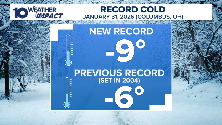

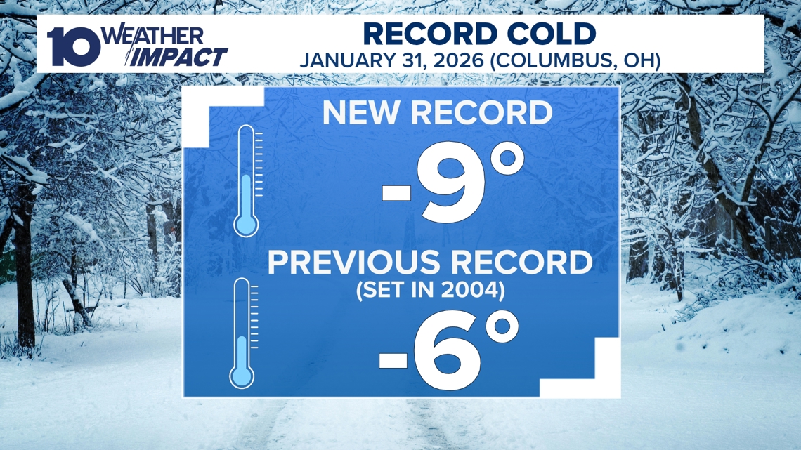
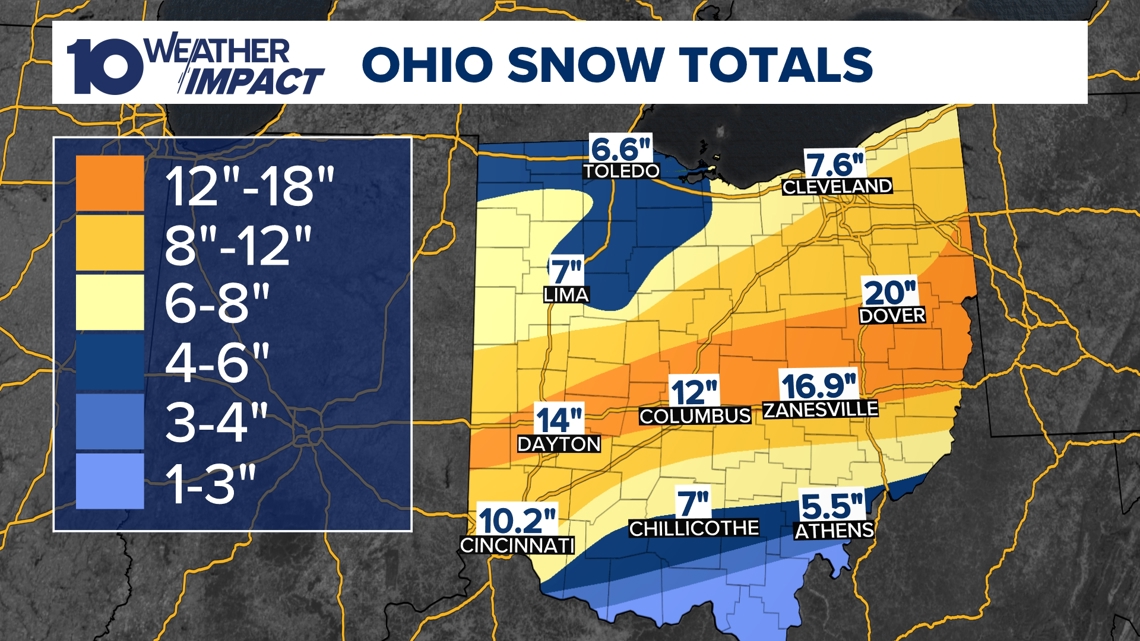
Columbus Hits Record Low Amid Deep Snowpack On Saturday morning January 31, Columbus recorded a historic –9°F at John Glenn Airport, shattering the prior –6°F record [4]. Snow depths across central Ohio ranged from 8 to over 16 inches, creating a thick snowpack that amplified the cold [2][3]. The extreme chill prompted a 10 Weather Impact Alert Day that remained in effect through Sunday [2][3].
Arctic Canadian Air Keeps Temperatures Below 20°F A southward surge of arctic air from Canada locked the region in sub‑20°F temperatures for the weekend, preventing any warming until the following week [2][3]. Statewide snow cover persisted, with wind‑chill values plunging to –30°F in several locations, heightening frostbite risk [4]. The alert warned residents to limit travel and protect exposed skin as hazardous conditions continued [2][3].
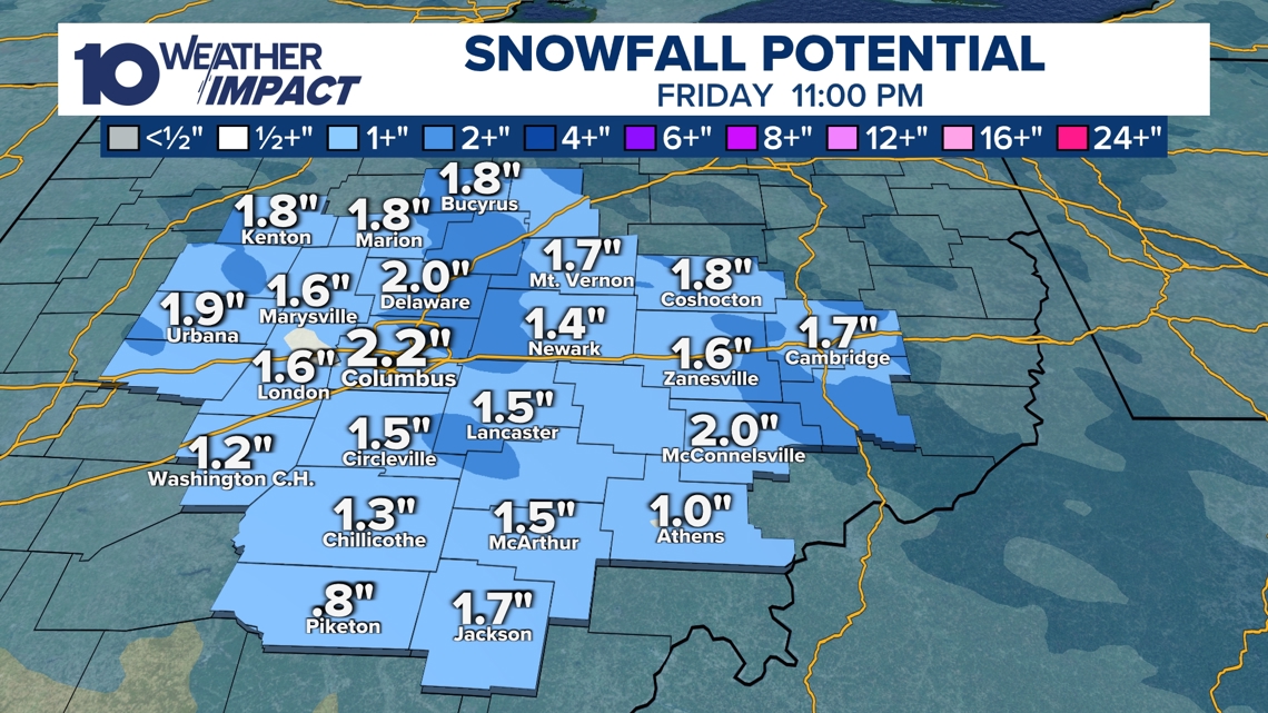
Friday System Brings Light Snow, Weekend Subzero Wind Chills Meteorologists expect two low‑pressure systems this week: a modest Tuesday front that dropped 1‑2 inches near I‑70, and a broader Friday system projected to deliver a dusting to a couple of inches across central Ohio [1]. After Friday’s system passes, a surge of colder air will produce subzero wind chills Saturday and Sunday mornings, renewing frostbite concerns [1]. The 10 Weather Impact team continues to monitor the evolving pattern and issue updates through its portal [1].
Forecast Calls for Gradual Warmup and Ongoing Alerts Computer models show daytime highs climbing into the 20s and approaching 30°F early next week, offering relief after the deep freeze [1][4]. Residents can follow live updates via the free 10TV+ streaming service and the 10 Weather Impact website, where meteorologist Aaron White provides regular briefings [4][2]. The agency urges continued vigilance as lingering snowpack may still influence local conditions.
Sources
-
1.
WBNS: Central Ohio Braces for Light Snow Friday and Subzero Weekend Temperatures – Details the upcoming Friday snow, Tuesday’s light accumulation, and subzero wind chills expected over the weekend, with forecasts of a warming trend early next week .
-
2.
WBNS: Columbus Endures Record Cold as Snowpack Persists, Warmer Weather Expected Next Week – Highlights the record –9°F low, 8‑16+ inch snowpack, and the expectation that temperatures stay below 20°F until a gradual warmup next week .
-
3.
WBNS: Columbus Record Low and Snowpack Keep Central Ohio in Deep Freeze – Reiterates the –9°F record, extended alert day, and persistent statewide snow cover, emphasizing the arctic air’s impact .
-
4.
WBNS: Columbus Sets New Record Low Temperature of –9°F – Reports the record low measured at John Glenn Airport, wind chills reaching –30°F, and provides meteorologist Aaron White’s contact information and streaming resources .
Timeline
Dec 5, 2025 – Ohio experiences record‑low wind chills for the season as temperatures sit in the single digits and teens while wind speeds drive wind‑chill values below the actual air temperature; forecasters predict a gradual warm‑up to the 20s‑30s by afternoon and mid‑30s over the weekend, though a wintry front is expected Sunday [13].
Dec 9‑10, 2025 – The 10 Weather Impact team issues a Weather Impact Alert Day for Wednesday as a strong storm system moves across the Midwest, delivering a rain‑snow mix in the morning followed by light snow showers later, minimal accumulations, and gusty winds up to 40 mph; a weaker system is forecast for Friday‑Saturday [12].
Dec 11‑14, 2025 – Heavy snow drops up to 9 inches on Saturday, accompanied by 25 mph winds; subzero wind chills persist Sunday and Monday, prompting snow emergencies, Cold Weather Advisories, and numerous school and church closures across central Ohio [11].
Dec 27‑28, 2025 – A strong low‑pressure system drives statewide wind gusts of 40‑50 mph on Monday, prompting Wind Advisories, power‑outage warnings, and a rapid temperature plunge into the low 20s by early Tuesday [9].
Dec 27‑28, 2025 – A separate storm system brings rain and thunderstorms Sunday night into Monday, places parts of Ohio in a Level 1 severe‑weather risk, and triggers a 40‑degree temperature drop in 12 hours, creating flash‑freeze hazards and possible snow in northern and western zones [10].
Dec 29‑31, 2025 – Snow showers arrive after 4 p.m., delivering 1‑3 inches of accumulation across central and southern Ohio; a Weather Impact Alert warns travelers heading to the OSU football game and New Year’s Eve events, while wind chills remain in the teens and temperatures stay in the 20s [8].
Jan 1, 2026 – Central Ohio sees up to 2 inches of snow overnight, prompting a Weather Impact Alert Day to protect New Year’s Eve travelers and Ohio State football fans; snow totals average 0.5‑1.5 inches, temperatures linger in the 20s, and the alert coordinates travel advisories [7].
Jan 11, 2026 – A northwest airflow ushers in colder air, dropping temperatures into the 20s overnight; a band of snow showers brings dustings to a half‑inch from night into Sunday, wind chills plunge into the 10s‑20s, and sunshine on Monday‑Tuesday lifts highs into the 40s [6].
Jan 20‑21, 2026 – The 10 Weather Impact team issues a Winter Storm Watch for six southern counties (Athens, Highland, Jackson, Pike, Ross, Scioto) from Saturday 7 a.m. to Monday 7 a.m.; temperatures fall into the single digits with subzero wind chills Friday night through Monday morning, and snow chances peak Saturday evening into Sunday afternoon, though the heaviest snow remains south of the viewing area [5].
Jan 26‑27, 2026 – Columbus sets a new all‑time low of –9 °F on Saturday, shattering the previous –6 °F record; snowpack deepens to 8‑16+ inches statewide, the arctic air mass keeps temperatures below 20 °F through the weekend, and the 10 Weather Impact Alert Day extends through Sunday morning [2][3].
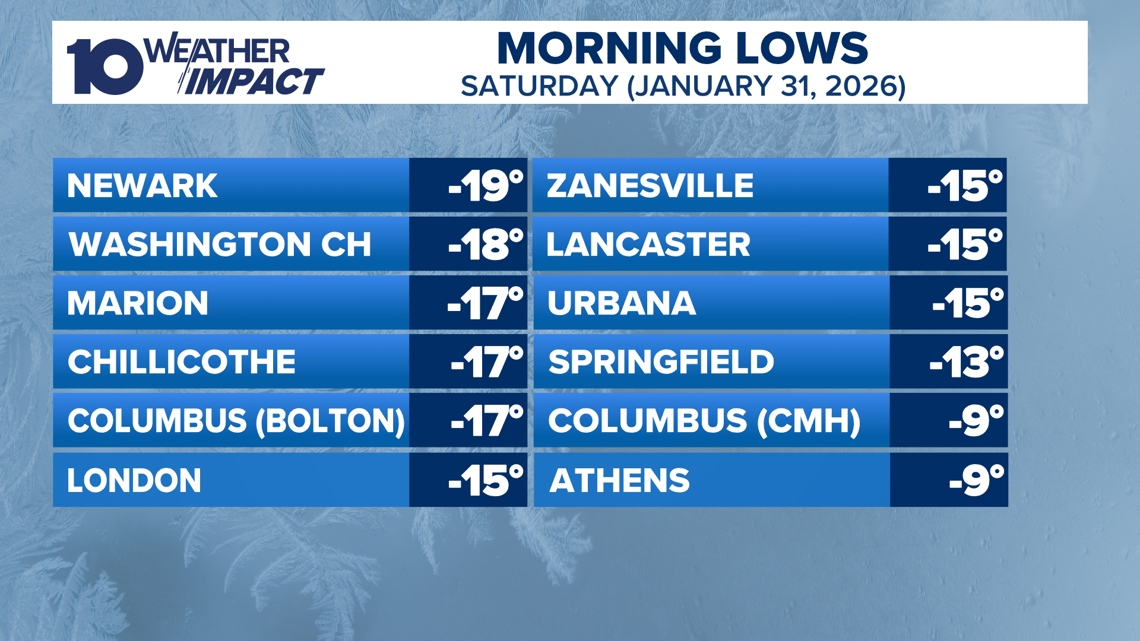
Jan 31, 2026 – Columbus records a –9 °F reading at John Glenn Airport, with nearby locations reporting –10 °F to –19 °F and wind chills near –30 °F; meteorologists forecast a gradual warm‑up to the 20s‑30s next week, though sub‑freezing persists into mid‑February [4].
Feb 2‑5, 2026 – Two low‑pressure systems move through central Ohio, the first on Tuesday delivering 1‑2 inches near I‑70 and the second on Friday promising a broader light snowfall of a dusting to a couple of inches; after Friday’s system clears, subzero wind chills hit Saturday and Sunday mornings, while computer models show temperatures rising above freezing early next week into the 40 °F range [1].
Dive deeper (11 sub-stories)
-
WBNS (Columbus, OH): Central Ohio Braces for Light Snow Friday and Subzero Weekend Temperatures
-
Columbus Hits Record –9°F, Snowpack Over 16 Inches, Cold to Last Until Next Week
(2 articles)
-
WBNS (Columbus, OH): Columbus Sets New Record Low Temperature of –9°F
-
WBNS (Columbus, OH): Central Ohio braces for weekend snow and subzero wind chills as arctic blast returns
-
WBNS (Columbus, OH): Snow showers expected in central Ohio overnight into Sunday as cold air moves in
-
Central Ohio Braces for Up to Two Inches of Snow as Weather Impact Alert Day Begins
(2 articles)
-
WBNS (Columbus, OH): Central Ohio braces for 40-50 mph wind gusts Monday as a strong low pressure system moves through
-
WBNS (Columbus, OH): Storm system may bring thunderstorms to central Ohio overnight
-
WBNS (Columbus, OH): Sub-zero wind chills Sunday & Monday after heavy snow Saturday
-
WBNS (Columbus, OH): Rain, snow and wind impacting Wednesday morning commute in central Ohio
-
WBNS (Columbus, OH): Ohio Experiences Record Low Wind Chills on Friday Morning
All related articles (13 articles)
-
WBNS (Columbus, OH): Central Ohio Braces for Light Snow Friday and Subzero Weekend Temperatures
-
WBNS (Columbus, OH): Columbus Endures Record Cold as Snowpack Persists, Warmer Weather Expected Next Week
-
WBNS (Columbus, OH): Columbus Record Low and Snowpack Keep Central Ohio in Deep Freeze
-
WBNS (Columbus, OH): Columbus Sets New Record Low Temperature of –9°F
-
WBNS (Columbus, OH): Central Ohio braces for weekend snow and subzero wind chills as arctic blast returns
-
WBNS (Columbus, OH): Snow showers expected in central Ohio overnight into Sunday as cold air moves in
-
WBNS (Columbus, OH): Central Ohio braces for up to 2 inches of snow as Weather Impact Alert Day is issued
-
WBNS (Columbus, OH): Snow expected this evening across central and southern Ohio with 1-3 inches of accumulation
-
WBNS (Columbus, OH): Central Ohio braces for 40-50 mph wind gusts Monday as a strong low pressure system moves through
-
WBNS (Columbus, OH): Storm system may bring thunderstorms to central Ohio overnight
-
WBNS (Columbus, OH): Sub-zero wind chills Sunday & Monday after heavy snow Saturday
-
WBNS (Columbus, OH): Rain, snow and wind impacting Wednesday morning commute in central Ohio
-
WBNS (Columbus, OH): Ohio Experiences Record Low Wind Chills on Friday Morning
External resources (3 links)
- http://facebook.com/AaronWhiteTV/ (cited 2 times)
- http://instagram.com/aaronwhitetv/ (cited 2 times)
- http://x.com/AaronWhiteTV (cited 2 times)