Western Washington Faces Week‑Long Storms, Snow, and 50‑Mph Gusts Starting Sunday
Updated (15 articles)
Multi‑front Storm Sequence Brings Rain, Snow, and Strong Winds series of low‑pressure systems will sweep western Washington from Saturday night through the following week, delivering rain to valleys and snow to elevations above 1,500 ft, with the first front already producing 0.1‑0.75 inches of rain and 3‑6 inches of mountain snow [1][2]. The offshore upper‑level low will generate repeated rounds of precipitation, keeping temperatures in the low 50s and maintaining active weather through mid‑week [1]. Models forecast 1‑3 inches of rain at lower elevations and several feet of snow in the high Cascades by week’s end [1][2].
Wind Advisory Issues Gusts Up to 50 mph Along Coast and Foothills Wind Advisory is in effect for the North and Central Coast and the Cascade Foothills through 10 a.m. Sunday, with easterly gap winds expected to reach 40‑50 mph [1][2]. The advisory, issued by the National Weather Service, targets coastal and foothill zones where gusts could cause power outages and hazardous travel [1]. Residents are urged to secure loose objects and monitor updates as the wind threat persists into the weekend [1].
Snow Levels Rise Then Fall, Affecting Accumulations Snow elevations climb to 2,000‑2,500 ft on Saturday, rise to 3,500‑4,000 ft by Sunday‑Monday, then gradually descend to 2,500‑3,000 ft by Thursday, shaping where snow will accumulate [1][2][5]. Mountain areas above 4,500 ft could see up to 6 inches of snow, while lower slopes receive 3‑6 inches; the lingering offshore storm keeps snow levels near 4,000 ft before the mid‑week drop [1]. Forecasts anticipate several feet of snow in the high Cascades by the end of next week, bolstering the regional snowpack despite current deficits [2].
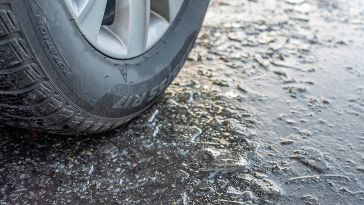
Spotty Lowland Snow Expected, Roads Mostly Slushy Snow levels dropping to 500‑1,000 ft on Wednesday could produce brief low‑elevation snow in Snohomish, King, and Pierce counties, echoing earlier bursts on Feb 17‑19 that caused school delays but left roads mainly slushy [3][5]. Intermittent rain‑snow mixes may create slick patches when precipitation pauses and temperatures refreeze, especially on the Kitsap Peninsula and coastal foothills [5]. Overall impacts on lowland communities remain limited, though drivers should stay alert for occasional icy spots [5].
Sources
-
1.
King5: Western Washington Braces for Week‑Long Storm Sequence: Details the upcoming succession of fronts, rain‑snow totals, wind advisory, and mountain snow forecasts for the next week .
-
2.
King5: Western Washington Braces for Rain, Snow and Strong Winds Through Next Week: Emphasizes the same storm pattern a day earlier, highlighting wind advisory specifics and model predictions of multiple feet of mountain snow .
-
3.
King5: Spotty Lowland Snow Hits Snohomish, King, and Pierce Counties: Reports brief low‑elevation snow on Feb 19, school delays, and minimal road impacts, illustrating how lowland snow can occur despite generally higher snow levels .
-
4.
King5: Washington Snowpack Lags Normal, Raising Summer Water Concerns: Provides context on the statewide snowpack deficit (≈65 % of normal) and its implications for water resources, underscoring why upcoming snow is closely watched .
-
5.
King5: Lowland Snow Possible Wednesday as Western Washington Precipitation Increases: Forecasts low‑elevation snow on Feb 17‑18, discusses mixed precipitation, and warns of slick roads, offering a short‑term view that aligns with the later storm sequence .
Related Tickers
Timeline
Dec 17 2025 – Winds ease and a cooler pattern settle over western Washington, allowing snow levels to drop and prompting forecasts of 5‑10 inches at Snoqualmie and Stevens Pass; an atmospheric river is expected Thursday, bringing rain to lowlands and 1‑2 inches of mountain snow, while forecasters warn of lingering wind‑related hazards [15].
Dec 19 2025 – Warm weather leaves the West with well‑below‑average snowpack, forcing Lake Tahoe lifts to run at minimal capacity and prompting Utah’s Midway Ice Castles to be postponed indefinitely; “the area hosting part of the 2034 Winter Olympics has averaged temperatures well above normal,” notes a local official, while record‑warm Novembers in Oregon, Idaho and Colorado further erode snow accumulation [2][14].
Dec 20 2025 – Heavy mountain snow returns to the Cascades ahead of Christmas, with Stevens Pass receiving more than 18 inches and Snoqualmie Pass about 10 inches in the past 48 hours; officials warn that travel could become hazardous, especially Sunday night, as snow levels sit near 2,000‑3,000 ft [13].
Dec 26 2025 – The National Weather Service issues a Winter Weather Advisory for Cascade passes, forecasting 6‑12 inches of snow across Snohomish, King, Whatcom and Skagit counties and urging travelers to carry emergency kits and monitor road conditions [12].
Dec 27 2025 – Light snow lingers in the Puget Sound convergence zone, delivering up to 2 inches in Snohomish and King counties while a ridge of high pressure keeps the region dry through New Year’s Eve; a new system is expected late Wednesday or Thursday, bringing “gradual warming of a few degrees,” according to forecasters [11].
Jan 8 2026 – A colder system moves through western Washington, dropping snow levels to about 500 ft overnight and producing spotty lowland snow or rain‑snow mixes early Thursday; the mountains remain under a Winter Storm Warning with 2‑4 feet of additional snow expected [10].
Jan 29 2026 – Despite recent snowfall, the Cascade Mountains’ snowpack stays far below normal, with deficits especially pronounced in the central and southern Cascades; experts warn the shortfall threatens spring streamflow and water supplies across the region [9].
Feb 4 2026 – Skiers at Snoqualmie Pass encounter “spring‑like” conditions as the regional snowpack falls under 50 % of normal, prompting Mount Hood Skibowl to halt operations indefinitely; meteorologist Shel Winkley calls it “the worst snow drought on record” [8].
Feb 9 2026 – The western U.S. endures a snow drought that cripples Utah winter tourism—owner Brad Riesenberg reports “customers are canceling tours” and ranks the season among his worst—while a persistent high‑pressure ridge keeps storms away, raising concerns for Colorado River water supplies and the 2034 Salt Lake City Winter Olympics [1].
Feb 17 2026 – Snow levels in western Washington plunge to 500‑1,000 ft, making lowland snow possible on Wednesday; meteorologist Rich Marriott notes a rain‑snow mix could affect the Kitsap Peninsula, while mountains are set to gain 6‑12 inches of snow by week’s end [7].
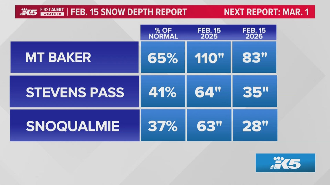
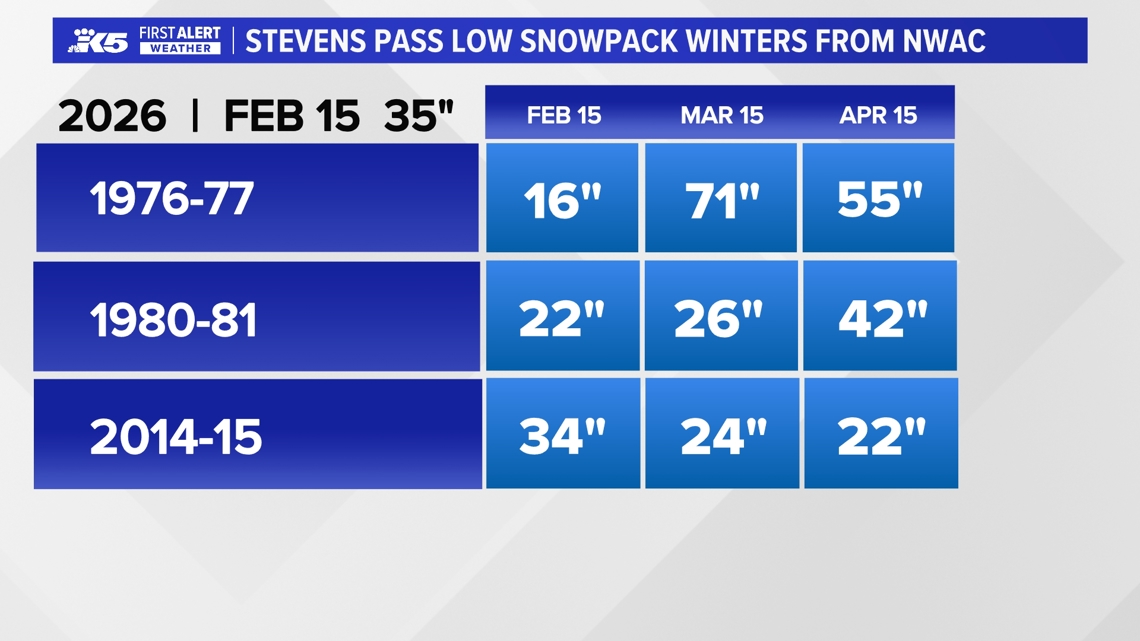
Feb 18 2026 – Washington’s statewide snowpack sits at roughly 65 % of normal, with Snoqualmie Pass hardest hit at only 40 % of typical depth; models forecast more snow but prevailing winds limit capture, and a weak La Niña is shifting toward neutral, giving a 50‑60 % chance of a weak El Niño next winter—mirroring past El Niño‑linked low‑snow winters of 1976‑77, 1980‑81 and 2014‑15 [6].
Feb 19 2026 – Spotty lowland snow bursts across Snohomish, King and Pierce counties, prompting a two‑hour delay at Granite Falls schools; snow levels hover between 500‑1,000 ft through Friday, with only minimal accumulation expected on roadways [5].
Feb 21‑22 2026 – A succession of low‑pressure fronts brings rain, snow and gusty winds to western Washington for a week‑long period; snow levels rise to 2,000‑2,500 ft early on then fall to 2,500‑3,000 ft by mid‑week, delivering 3‑6 inches of mountain snow (more above 4,500 ft) and prompting a Wind Advisory with gusts of 40‑50 mph [3][4].
Dive deeper (4 sub-stories)
-
Western Washington Faces Week‑Long Storms, Strong Winds, and Snowpack Concerns
(10 articles)
-
King5 (Seattle, WA): Spotty Lowland Snow Hits Snohomish, King, and Pierce Counties
-
King5 (Seattle, WA): Spring‑like Ski Conditions Hit Snoqualmie Pass as Snowpack Plummets
-
Western U.S. Snow Drought Deepens, Threatening Tourism, Water Supplies, 2034 Olympics
(3 articles)
All related articles (15 articles)
-
King5 (Seattle, WA): Western Washington Braces for Week‑Long Storm Sequence
-
King5 (Seattle, WA): Western Washington Braces for Rain, Snow and Strong Winds Through Next Week
-
King5 (Seattle, WA): Spotty Lowland Snow Hits Snohomish, King, and Pierce Counties
-
King5 (Seattle, WA): Washington Snowpack Lags Normal, Raising Summer Water Concerns
-
King5 (Seattle, WA): Lowland Snow Possible Wednesday as Western Washington Precipitation Increases
-
King5 (Seattle, WA): Spring‑like Ski Conditions Hit Snoqualmie Pass as Snowpack Plummets
-
King5 (Seattle, WA): Cascade Mountains Snowpack Lags Behind Recent Snowfall
-
CNN: The western US is in a snow drought, raising fears for summer water supplies
-
King5 (Seattle, WA): Snow levels fall overnight across western Washington, raising chance of lowland wet snow and slick roads
-
King5 (Seattle, WA): Western Washington sees light snow, then dry stretch with freezing nights ahead
-
King5 (Seattle, WA): Snow could complicate post-Christmas mountain pass travel in Washington
-
King5 (Seattle, WA): Heavy mountain snow continues toward Christmas across Cascades, with up to 2–3 feet possible at some passes
-
King5 (Seattle, WA): Warm weather and low snowpack disrupt Western ski resorts
-
AP: Warm weather and low snowpack slow Western ski resorts
-
King5 (Seattle, WA): Blustery weather eases in western Washington
External resources (14 links)
- https://nwcc-apps.sc.egov.usda.gov/imap/#version=2&elements=&networks=!&states=!&basins=!&hucs=&minElevation=&maxElevation=&elementSelectType=any&activeOnly=true&activeForecastPointsOnly=true&hucLabels=false&hucIdLabels=false&hucParameterLabels=true&stationLabels=&overlays=&hucOverlays=state&basinOpacity=100&basinNoDataOpacity=100&basemapOpacity=100&maskOpacity=0&mode=data&openSections=dataElement,parameter,date,basin,options,elements,location,networks,baseMaps,overlays,labels&controlsOpen=true&popup=&popupMulti=&popupBasin=&base=esriWgc&displayType=basin&basinType=6&dataElement=SNWD&depth=-8¶meter=PCTPORMED&frequency=MONTHLY&duration=I&customDuration=&dayPart=E&monthPart=E&forecastPubDay=1&forecastExceedance=50&useMixedPast=true&seqColor=2&divColor=7&scaleType=D&scaleMin=&scaleMax=&referencePeriodType=POR&referenceBegin=1991&referenceEnd=2020&minimumYears=20&hucAssociations=true&relativeDate=-1&lat=41.305&lon=-112.429&zoom=5.5 (cited 2 times)
- https://forecast.weather.gov/wwamap/wwatxtget.php?cwa=SEW&wwa=wind%20advisory (cited 1 times)
- https://forecast.weather.gov/wwamap/wwatxtget.php?cwa=SEW&wwa=wind%2520advisory (cited 1 times)
- https://forecast.weather.gov/wwamap/wwatxtget.php?cwa=SEW&wwa=winter%2520weather%2520advisory (cited 1 times)
- https://nwcc-apps.sc.egov.usda.gov/imap/#version=169&elements=&networks=!MSNT&states=!&basins=!&hucs=&minElevation=&maxElevation=&elementSelectType=any&activeOnly=true&activeForecastPointsOnly=false&hucLabels=true&hucIdLabels=false&hucParameterLabels=true&stationLabels=&overlays=&hucOverlays=state&basinOpacity=75&basinNoDataOpacity=0&basemapOpacity=100&maskOpacity=100&mode=data&openSections=dataElement,parameter,date,basin,options,elements,location,networks,baseMaps,overlays,labels&controlsOpen=true&popup=&popupMulti=&popupBasin=&base=esriWsr&displayType=basin&basinType=wa_8&dataElement=WTEQ&depth=-8¶meter=PCTMED&frequency=DAILY&duration=I&customDuration=&dayPart=E&monthPart=B&forecastPubDay=1&forecastExceedance=50&useMixedPast=true&seqColor=1&divColor=7&scaleType=D&scaleMin=&scaleMax=&referencePeriodType=fixed&referenceBegin=1991&referenceEnd=2020&minimumYears=20&hucAssociations=true&relativeDate=-1&lat=48.124&lon=-120.914&zoom=6.9&autoExport=full,pdf,2,2,L,BL,Washington%2520SNOTEL,49.4893,44.9175,-114.8615,-125.2705 (cited 1 times)
- https://wsdot.com/travel/real-time/mountainpasses/Blewett (cited 1 times)
- https://wsdot.com/travel/real-time/mountainpasses/Cayuse (cited 1 times)
- https://wsdot.com/travel/real-time/mountainpasses/Chinook (cited 1 times)
- https://wsdot.com/travel/real-time/mountainpasses/Crystal-to-Greenwater (cited 1 times)
- https://wsdot.com/travel/real-time/mountainpasses/Mt.-Baker (cited 1 times)
- https://wsdot.com/travel/real-time/mountainpasses/North-Cascade-Hwy (cited 1 times)
- https://wsdot.com/travel/real-time/mountainpasses/Snoqualmie (cited 1 times)
- https://wsdot.com/travel/real-time/mountainpasses/Stevens (cited 1 times)
- https://wsdot.com/travel/real-time/mountainpasses/White (cited 1 times)