Snow Returns to Central Ohio With New Advisory and Two More Systems This Week
Updated (17 articles)
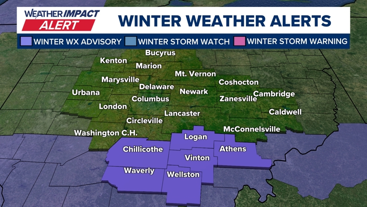
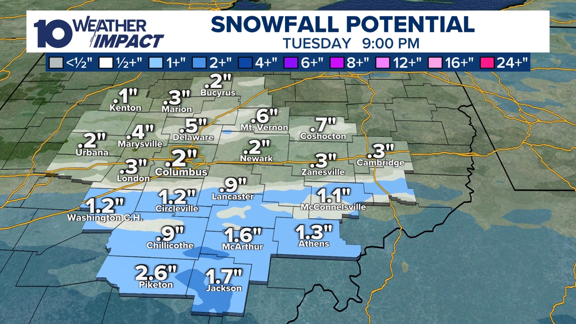
Flurries and Light Snow Expected Tuesday Near I‑70 Flurries moved through central Ohio on Monday, and a narrow band of light‑to‑moderate snow will hit areas near and south of Interstate 70 Tuesday morning into the afternoon, bringing 1‑3 inches of accumulation. A Winter Weather Advisory now covers Chillicothe, Piketon, Jackson and Athens, among other southern Ohio cities. The advisory was issued by the 10 Weather Impact meteorologists as the system approaches [1].
Mid‑Week Temperatures Drop Into the 20s, Followed by Friday Snow After Tuesday’s snowfall clears, highs are projected to fall into the 20 °F range on Wednesday and Thursday as colder air moves in. A broader but lighter system on Friday could produce a dusting to two inches across most of central Ohio, offering a wider snowfall footprint than Tuesday’s narrow band. The Friday event will be followed by subzero wind‑chill values Saturday and Sunday [1].
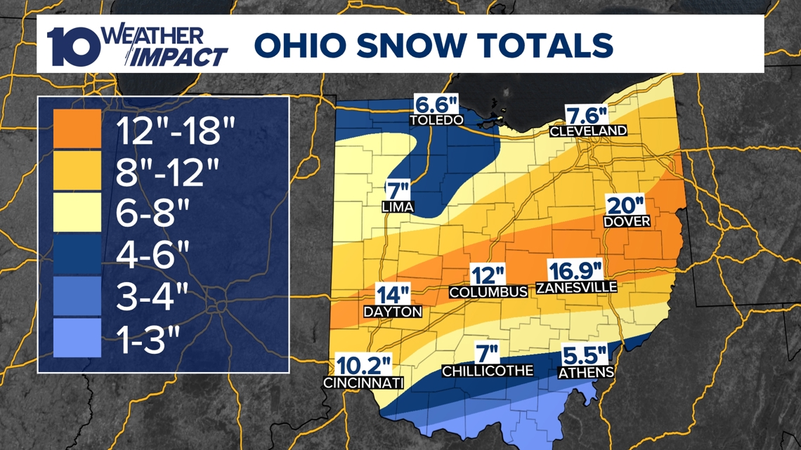
Late‑January Storm Dropped 16‑Plus Inches and Triggered Emergencies The major winter storm that struck the weekend of Jan 27 delivered more than 16 inches of snow to central Ohio, with the Columbus metro area receiving about a foot and Zanesville reporting nearly 17 inches [2]. Snow emergencies were declared, with Franklin County at Level 2 and several southern counties at Level 3, restricting road travel to emergency vehicles. Schools across the region canceled classes on Tuesday, and subzero temperatures with wind chills of –10 °F to –20 °F persisted through the week [2][3].
Maximum Snowfall Reports Vary Between 16‑Plus and 20 Inches One report cites “over 16 inches” as the storm total, while another records a peak of 20 inches in Dover, Tuscarawas County [2][3]. The discrepancy reflects differing measurement sites—Zanesville’s 17‑inch total versus Dover’s 20‑inch reading—and highlights ongoing efforts to verify community‑submitted snowfall data [3].
Sources
-
1.
WBNS (Columbus, OH): Snow Returns to Central Ohio This Week: Details flurries, a Tuesday advisory for southern Ohio, mid‑week temperature dip, a Friday dusting, and subzero weekend wind chills .
-
2.
WBNS (Columbus, OH): Ohio Winter Storm Leaves Over 16 Inches of Snow and Triggers Snow Emergencies: Summarizes the Jan 27 storm’s 16+‑inch accumulations, Level 2/3 emergencies, school closures, and extreme cold alerts .
-
3.
WBNS (Columbus, OH): Central Ohio Receives Up to 20 Inches of Snow as Major Winter Storm Ends: Reports a 20‑inch peak in Dover, emergency levels, subzero forecasts, and a call for public snowfall reports .
Timeline
Dec 2, 2025 – Central Ohio receives 3‑5 inches of snow Tuesday morning, with Worthington reporting over 6 inches, prompting slippery roads and school cancellations; forecasters note another system approaching the Ohio Valley[17].
Dec 5, 2025 – Ohio experiences record‑low wind chills as temperatures stay in the single digits and teens while strong winds amplify the cold, and officials forecast a gradual warm‑up into the 20s‑30s by afternoon[16].
Dec 9, 2025 – A mixed rain‑snow storm hits central Ohio Wednesday morning, producing minimal snow accumulation but slick, low‑visibility roads; wind gusts reach 40 mph and a weaker system is expected Friday‑Saturday[15].
Dec 13, 2025 – A winter storm drops 1‑9 inches of snow across central Ohio, setting a new record of 5.4 inches at John Glenn Columbus International Airport and prompting snow‑emergency levels 2‑3 in several counties[13].
Dec 14, 2025 – Snow totals up to 9 inches fall Saturday, with winds up to 25 mph and blowing snow causing near‑zero wind chills; multiple counties declare snow emergencies and Cold Weather Advisories are issued[14].
Dec 27, 2025 – A developing storm system moves into central Ohio Sunday night into Monday, bringing rain and thunderstorms with a Level 1 severe‑weather risk and potential 60‑mph wind gusts; a sharp 40‑degree temperature drop follows the cold front, creating flash‑freeze hazards Monday morning[12].
Dec 28, 2025 – A strong low‑pressure system drives Monday winds, producing 40‑50 mph gusts statewide and dropping temperatures into the low 20s by early Tuesday, prompting Wind Advisories and alerts for possible power outages[11].
Dec 31, 2025 – Snow showers arrive after 4 p.m. across central and southern Ohio, delivering 1‑3 inches of accumulation with wind chills in the teens; a Weather Impact Alert warns travelers heading to the OSU game and New Year’s Eve events[10].
Jan 1, 2026 – A Weather Impact Alert Day flags up to 2 inches of snow for central Ohio, with 0.5‑1.5 inch totals expected and wind chills in the teens, aiming to protect OSU game‑goers and New Year’s plans[9].
Jan 11, 2026 – A northwest airflow brings colder air into central Ohio, dropping temperatures into the 20s overnight; light snow showers may produce dustings to a half‑inch Sunday, while wind chills plunge into the teens‑20s and sunshine returns with 40 °F highs Monday‑Tuesday[8].
Jan 20, 2026 – A Winter Storm Watch covers six southern Ohio counties as an arctic blast drives temperatures into single digits and subzero wind chills Friday night through Monday, with the worst wind‑chill impacts Friday night‑Saturday and possible light snow Saturday evening into Sunday[7].
Jan 21, 2026 – A major winter storm leaves more than 16 inches of snow in parts of central Ohio and about a foot in the Columbus metro, triggers Level 2‑3 snow emergencies, and brings arctic air with wind chills of –10 °F to –20 °F through the week[3].
Jan 23, 2026 – Governor Mike DeWine urges Ohioans to “stay home” as a 6‑12‑inch snow event approaches central Ohio; ODOT readies 1,500 trucks and 3,000 workers with de‑icing chemicals, while Lt. Brice Nihiser cautions drivers to slow down[6].
Jan 24, 2026 – Columbus Mayor Andrew Ginther briefs residents on the impending storm, outlines shelter resources, and announces a follow‑up briefing at 4 p.m.; the Snow Warriors prepare to clear 8‑12 inches, ODOT deploys 1,500 trucks, and wind chills are forecast at –5 °F to –15 °F[5].
Jan 25, 2026 – Six cars become stranded on I‑70 West near US 33 as snow intensifies, prompting a brief lane closure that reopens within two hours; Franklin County declares a Level 2 Snow Emergency after six inches fall, and a Winter Storm Warning spans all 88 Ohio counties predicting up to 16 inches this weekend[4].
Jan 25, 2026 – The major winter storm that began Saturday night ends Sunday with a peak accumulation of 20 inches in Dover, prompting Snow Emergencies across multiple counties (Franklin Level 2) and subzero temperatures with wind chills of –10 °F to –20 °F persisting through the week[2].
Feb 2, 2026 – Snow returns to central Ohio this week as flurries and snow showers move through Monday, with a narrow band delivering 1‑3 inches Tuesday near I‑70 and a Winter Weather Advisory covering Chillicothe, Piketon, Jackson and Athens; temperatures dip into the 20s mid‑week, a broader Friday system may bring up to two inches, and subzero wind chills are expected Saturday‑Sunday before a warming trend lifts highs into the 40s by next week[1].
Dive deeper (14 sub-stories)
-
Snow Returns to Central Ohio With Advisory, Two More Systems Expected This Week
(2 articles)
-
WBNS (Columbus, OH): Ohio Winter Storm Leaves Over 16 Inches of Snow and Triggers Snow Emergencies
-
Central Ohio Faces Up to 14 Inches of Snow, Sub‑Zero Temperatures, and Widespread Emergencies
(2 articles)
-
WBNS (Columbus, OH): Cars stuck on I‑70 West as snow intensifies, highways reopen
-
WBNS (Columbus, OH): Columbus Mayor Updates Residents Ahead of Major Winter Storm
-
WBNS (Columbus, OH): DeWine and state officials urge caution as winter storm looms over central Ohio
-
WBNS (Columbus, OH): Central Ohio braces for weekend snow and subzero wind chills as arctic blast returns
-
WBNS (Columbus, OH): Snow showers expected in central Ohio overnight into Sunday as cold air moves in
-
Central Ohio Braces for Up to Two Inches of Snow Ahead of New Year’s Celebrations
(2 articles)
-
WBNS (Columbus, OH): Central Ohio braces for 40-50 mph wind gusts Monday as a strong low pressure system moves through
-
WBNS (Columbus, OH): Storm system may bring thunderstorms to central Ohio overnight
-
WBNS (Columbus, OH): Sub-zero wind chills Sunday & Monday after heavy snow Saturday
-
WBNS (Columbus, OH): Rain, snow and wind impacting Wednesday morning commute in central Ohio
-
WBNS (Columbus, OH): Ohio Experiences Record Low Wind Chills on Friday Morning
All related articles (17 articles)
-
WBNS (Columbus, OH): Snow Returns to Central Ohio This Week
-
WBNS (Columbus, OH): Ohio Winter Storm Leaves Over 16 Inches of Snow and Triggers Snow Emergencies
-
WBNS (Columbus, OH): Central Ohio Receives Up to 20 Inches of Snow as Major Winter Storm Ends
-
WBNS (Columbus, OH): Cars stuck on I‑70 West as snow intensifies, highways reopen
-
WBNS (Columbus, OH): Columbus Mayor Updates Residents Ahead of Major Winter Storm
-
WBNS (Columbus, OH): DeWine and state officials urge caution as winter storm looms over central Ohio
-
WBNS (Columbus, OH): Central Ohio braces for weekend snow and subzero wind chills as arctic blast returns
-
WBNS (Columbus, OH): Snow showers expected in central Ohio overnight into Sunday as cold air moves in
-
WBNS (Columbus, OH): Central Ohio braces for up to 2 inches of snow as Weather Impact Alert Day is issued
-
WBNS (Columbus, OH): Snow expected this evening across central and southern Ohio with 1-3 inches of accumulation
-
WBNS (Columbus, OH): Central Ohio braces for 40-50 mph wind gusts Monday as a strong low pressure system moves through
-
WBNS (Columbus, OH): Storm system may bring thunderstorms to central Ohio overnight
-
WBNS (Columbus, OH): Sub-zero wind chills Sunday & Monday after heavy snow Saturday
-
WBNS (Columbus, OH): Winter storm brings several inches of snow to central Ohio: Current snowfall totals
-
WBNS (Columbus, OH): Rain, snow and wind impacting Wednesday morning commute in central Ohio
-
WBNS (Columbus, OH): Ohio Experiences Record Low Wind Chills on Friday Morning
-
WBNS (Columbus, OH): Central Ohio Receives Up to 5 inches of Snow Tuesday Morning
External resources (7 links)
- https://warriorwatch.columbus.gov/ (cited 1 times)
- http://facebook.com/AaronWhiteTV/ (cited 1 times)
- http://instagram.com/aaronwhitetv/ (cited 1 times)
- http://x.com/AaronWhiteTV (cited 1 times)
- https://www.facebook.com/AaronWhiteTV (cited 1 times)
- https://www.instagram.com/aaronwhitetv/ (cited 1 times)
- https://x.com/AaronWhiteTV (cited 1 times)