Light Snow Expected Friday as Subzero Wind Chills Return to Central Ohio
Updated (51 articles)

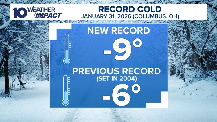

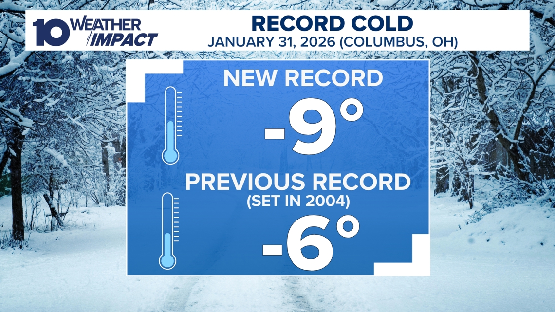
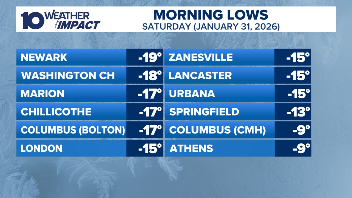
Record‑Breaking Cold Sets New Low for Columbus On Saturday, Jan. 31, Columbus recorded a historic –9 °F at John Glenn Airport, surpassing the previous –6 °F record, while nearby stations reported temperatures as low as –19 °F and wind chills reaching –30 °F, prompting hazardous‑condition warnings [4].
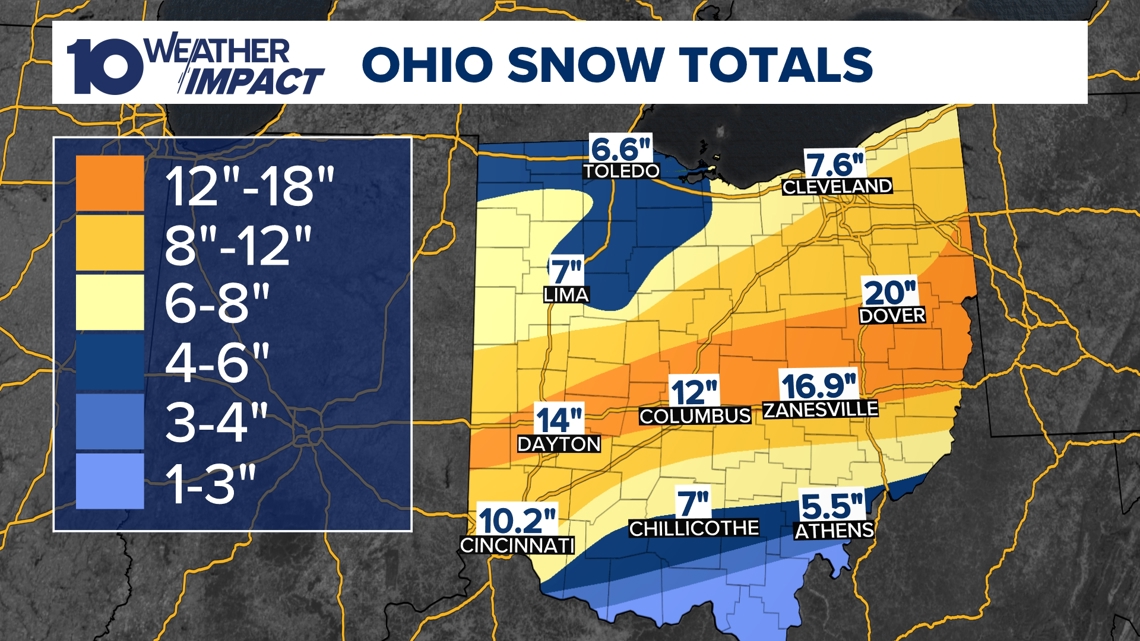
Snowpack Over Eight Inches Amplifies the Deep Freeze Central Ohio reported snow depths ranging from eight to more than sixteen inches, creating a continuous statewide snow cover that locked in the frigid air and limited any short‑term warming through the weekend [2][3][7].
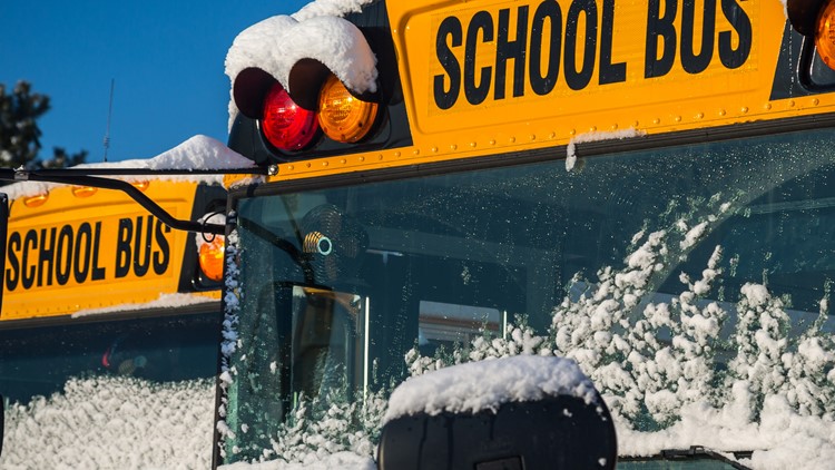
School Districts Remain Closed Amid Arctic Air, Plan Monday Reopenings Fifth‑day closures affected Columbus City Schools and dozens of district‑wide systems; Mayor Andrew Ginther announced a tentative Monday reopening as snow emergencies were lifted and priority roads cleared, though extreme cold, not road access, drove the delays [5][6][7][8].
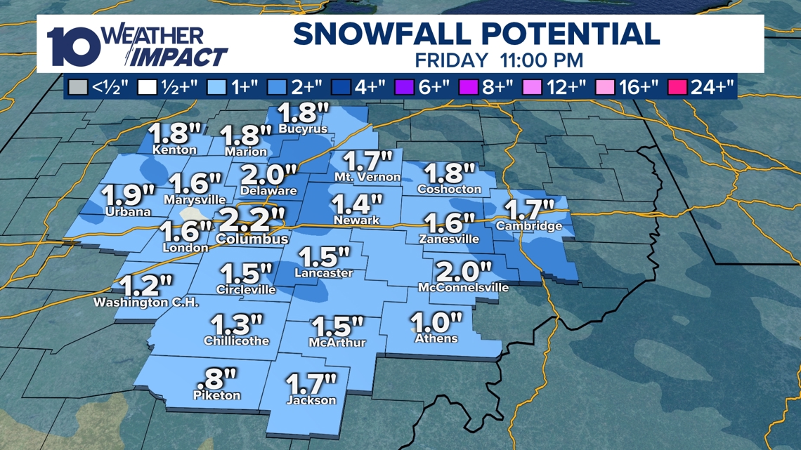
Friday’s Light Snow Followed by Subzero Wind Chills Predicted Meteorologists expect a broad but light snowfall Friday, with accumulations from a dusting up to two inches, after which a surge of arctic air will produce subzero wind chills Saturday and Sunday mornings, raising frostbite and travel‑hazard risks [1].
Models Show Temperatures Rising Above Freezing Early Next Week Forecasts indicate daytime highs climbing into the 20 °F range, with some days reaching the low 30s, ending the sub‑zero spell and allowing the 10 Weather Impact Alert Day to lapse after Sunday [1][4].
Sources
-
1.
WBNS: Central Ohio Braces for Light Snow Friday and Subzero Weekend Temperatures: Details the upcoming Friday snow system, expected light accumulations, and subzero wind chills over the weekend, emphasizing safety concerns .
-
2.
WBNS: Columbus Endures Record Cold as Snowpack Persists, Warmer Weather Expected Next Week: Highlights the –9 °F record, 8‑16+ inch snowpack, and a forecasted warming trend for the following week .
-
3.
WBNS: Columbus Record Low and Snowpack Keep Central Ohio in Deep Freeze: Reiterates the record low, extended alert day, and persistent snow cover reinforcing the deep freeze .
-
4.
WBNS: Columbus Sets New Record Low Temperature of –9°F: Reports the record low at John Glenn Airport, extreme wind chills, and a gradual warm‑up forecast for the next week .
-
5.
WBNS: Central Ohio Schools Set to Reopen After Snow‑Related Week‑Long Closures: Announces lifted snow emergencies, mayor’s plan for Monday school reopening, and the impact of frigid temperatures on closures .
-
6.
WBNS: Central Ohio Schools Remain Closed as Winter Storm Extends to Fifth Day: Describes the fifth consecutive school closure, parental coping strategies, and district‑wide cancellation updates .
-
7.
WBNS: Columbus City Schools Cancel Classes Friday Amid Ongoing Winter Storm and Extreme Cold: Covers the Friday cancellation, extensive snow accumulations, and an Extreme Cold Warning through Wednesday .
-
8.
WBNS: Central Ohio Schools Shut Down Friday Amid Arctic Cold: Lists the numerous districts canceling Friday classes, forecasts of subzero wind chills, and the upcoming warming trend starting Sunday .
Timeline
Dec 1, 2025 – A fast‑moving winter storm delivers the first widespread snow of the season to the interior Northeast and New England, dumping up to 10 inches and prompting a Level 3 Snow Emergency in Hocking County, Ohio; Kentucky Gov. Andy Beshear posts a photo of the snow‑covered mansion and urges residents to “drive slowly” on slick roadways[1].
Dec 2, 2025 – A powerful nor’easter advances into the Northeast, bringing several inches of snow to New York and Pennsylvania while New York City receives only rain; more than two dozen Ohio counties issue Snow Emergencies (Level 1‑3) and emergency crews rescue a tractor‑trailer driver whose cab hangs off a West Virginia bridge[2].
Dec 2, 2025 – Central Ohio receives 3‑6 inches of snow, with Columbus reporting over 4 inches; Level 2 and Level 3 snow emergencies restrict non‑essential travel across the region[26].
Dec 2, 2025 – Up to 5 inches of snow fall Tuesday morning across central Ohio, worsening road conditions before winter‑weather advisories are lifted later that day[27].
Dec 2, 2025 – Columbus City Schools cancel Tuesday classes due to overnight snow and slippery sidewalks, joining dozens of district closures throughout central Ohio[28].
Dec 2, 2025 – Franklin County courts close Tuesday as 2‑4 inches of snow accumulate; multiple school districts announce closures or delays amid snow emergencies ranging from Level 1 to Level 3[30].
Dec 9‑10, 2025 – A 10 Weather Impact Alert warns of a rain‑snow mix and wind gusts up to 40 mph affecting Wednesday commutes; minimal snow accumulations are expected as temperatures hover near freezing[24].
Dec 13‑14, 2025 – A winter storm drops 1‑9 inches of snow across central Ohio, setting a new record of 5.4 inches at John Glenn Columbus International Airport and prompting county‑wide snow emergencies[23].
Dec 14‑15, 2025 – Winds of up to 25 mph and blowing snow produce wind chills near or below 0 °F; several counties declare snow emergencies and the NWS issues Cold Weather Advisories[22].
Dec 15‑16, 2025 – More than a dozen central Ohio districts cancel or delay school start times; temperatures are forecast to rise into the 30s‑40s later in the week with rain expected Thursday[20].
Dec 27‑29, 2025 – A strong low‑pressure system drives 40‑50 mph wind gusts across Ohio on Monday, with gusts reaching 50‑60 mph in northern areas; temperatures plunge into the low‑20s and a Weather Impact Alert warns of possible power outages[19].
Jan 23, 2026 – Gov. Mike DeWine urges Ohioans to “stay home” as a winter storm threatens 6‑12 inches of snow for central Ohio; ODOT readies 1,500 trucks and 3,000 workers, noting 34 plow strikes already this year[16].
Jan 24, 2026 – Mayor Andrew Ginther briefs residents, announcing the “Snow Warriors” will clear 8‑12 inches of snow and ODOT will deploy 1,500 trucks; OSHP Lt. Brice Nihiser warns “unsafe speeds are the leading cause of weather‑related crashes,” and ODOT press secretary Matt Bruning says low temperatures will reduce standard salt effectiveness, requiring chemical additives[15].
Jan 25, 2026 – Kroger shuts 115 Columbus‑area stores early at 6 p.m. and Giant Eagle closes at 4 p.m. as a Level 3 snow emergency blankets all central Ohio counties and snowfall reaches 6‑12 inches[13].
Jan 25, 2026 – Six vehicles become stranded on I‑70 West near US 33 during heavy snow; the highway reopens after two hours, and forecasters warn the storm could dump up to 16 inches with wind chills of –10 °F to –20 °F[14].
Jan 26, 2026 – Columbus records an all‑time low of –9 °F, breaking the previous –6 °F record; snowpack measures 8‑16+ inches, and a Canadian arctic air mass will keep temperatures below 20 °F through the week[4][5].
Jan 26, 2026 – Level 2 Snow Emergency covers most central Ohio counties; over 16 inches of snow rank the storm as the fifth‑biggest on record for Columbus, and subzero wind chills persist through the week[10].
Jan 26, 2026 – The Columbus Zoo announces it will remain closed through Feb 1, stating “protecting the health of visitors, employees, and the animal collection” is its top priority amid more than 16 inches of snow and subzero wind chills[9].
Jan 26, 2026 – Columbus Blue Jackets postpone Monday night game vs. Kings to Mar 9, citing a foot of snow and extreme cold; the team confirms tickets remain valid for the rescheduled date[11].
Jan 27, 2026 – Columbus City Schools cancel Friday classes, extending an Extreme Cold Warning through Wednesday noon as wind chills dip to –25 °F and snow accumulations total 8‑16 inches[8].
Jan 29, 2026 – Columbus City Schools cancel Friday (fifth consecutive day) and other districts suspend Thursday classes; an Extreme Cold Warning remains in effect with temperatures below zero and wind chills as low as –25 °F[8].
Jan 30, 2026 – Mayor Andrew Ginther announces Columbus City Schools will reopen Monday after a week‑long closure, noting that “frigid temperatures, not road access, delayed schools”[7].
Jan 31, 2026 – Columbus hits a new record low of –9 °F at John Glenn Airport, with wind chills reaching –30 °F; meteorologists forecast daytime highs rising into the 20s‑30s next week, ending the sub‑zero spell[6].
Feb 1, 2026 – Columbus endures record cold as the snowpack persists; the 10 Weather Impact Alert Day extends through Sunday, and the arctic air mass keeps temperatures below 20 °F until the following week[4].
Feb 2, 2026 – Central Ohio braces for light snow Friday and subzero wind chills Saturday‑Sunday, with temperatures expected to rise above freezing early the next week[3].
Feb 5, 2026 – Forecasts indicate subzero wind chills will continue Saturday and Sunday, followed by a warming trend early next week, as the 10 Weather Impact team monitors evolving conditions[3].
Dive deeper (10 sub-stories)
-
Central Ohio Braces for Light Snow Friday as Subzero Wind Chills Return
(13 articles)
-
Central Ohio Schools Set to Reopen Monday After Record Snowstorm and Arctic Freeze
(17 articles)
-
WBNS (Columbus, OH): Central Ohio Schools Remain Closed as Winter Storm Extends to Fifth Day
-
Columbus Zoo Extends Shutdown to Feb. 1 After Record Snowstorm
(3 articles)
-
Ohio Winter Storm Dumps Up to 20 Inches, Triggers County Emergencies and School Closures
(9 articles)
-
WBNS (Columbus, OH): Central Ohio Towing Services Overwhelmed After Heavy Snowfall
-
WBNS (Columbus, OH): Columbus Blue Jackets game postponed to March 9 after heavy snowstorm
-
Ohio Endures Record Snowfall as Winter Storm Persists Through Monday
(2 articles)
-
Kroger and Giant Eagle Shut Hundreds of Ohio Stores Early as Snowstorm Deepens
(2 articles)
-
Dec 2 2025 Nor’easter Brings First Seasonal Snow, Fatalities and State Emergencies
(2 articles)
All related articles (51 articles)
-
WBNS (Columbus, OH): Central Ohio Braces for Light Snow Friday and Subzero Weekend Temperatures
-
WBNS (Columbus, OH): Columbus Endures Record Cold as Snowpack Persists, Warmer Weather Expected Next Week
-
WBNS (Columbus, OH): Columbus Record Low and Snowpack Keep Central Ohio in Deep Freeze
-
WBNS (Columbus, OH): Columbus Sets New Record Low Temperature of –9°F
-
WBNS (Columbus, OH): Central Ohio Schools Set to Reopen After Snow‑Related Week‑Long Closures
-
WBNS (Columbus, OH): Central Ohio Schools Remain Closed as Winter Storm Extends to Fifth Day
-
WBNS (Columbus, OH): Columbus City Schools Cancel Classes Friday Amid Ongoing Winter Storm and Extreme Cold
-
WBNS (Columbus, OH): Central Ohio Schools Shut Down Friday Amid Arctic Cold
-
WBNS (Columbus, OH): Columbus Zoo Remains Closed Through Feb. 1 Amid Record Snow and Subzero Cold
-
WBNS (Columbus, OH): Central Ohio School Districts Cancel Thursday Classes Amid Arctic Cold
-
WBNS (Columbus, OH): Central Ohio School Districts Close Wednesday Amid Deep Freeze
-
WBNS (Columbus, OH): Ohio Winter Storm Leaves Over 16 Inches of Snow and Triggers Snow Emergencies
-
WBNS (Columbus, OH): Central Ohio Receives Up to 20 Inches of Snow as Major Winter Storm Ends
-
WBNS (Columbus, OH): Central Ohio Towing Services Overwhelmed After Heavy Snowfall
-
WBNS (Columbus, OH): Central Ohio Business and School Closures After Record Snowstorm
-
WBNS (Columbus, OH): Central Ohio School Districts Close Tuesday Amid Heavy Snow and Arctic Cold
-
WBNS (Columbus, OH): Columbus Blue Jackets game postponed to March 9 after heavy snowstorm
-
WBNS (Columbus, OH): Central Ohio schools close Monday as historic snowstorm brings extreme cold
-
WBNS (Columbus, OH): 10TV Extends Live Winter Storm Coverage Across Ohio
-
WBNS (Columbus, OH): Kroger and Giant Eagle close stores early Sunday as Ohio winter storm intensifies
-
WBNS (Columbus, OH): Ohio State cancels in‑person classes Monday‑Tuesday as winter storm hits central Ohio
-
WBNS (Columbus, OH): Giant Eagle Closes All Ohio Stores Early Amid Snowstorm
-
WBNS (Columbus, OH): Ohio Snowstorm Forces Road Closures and Massive Plow Deployment
-
WBNS (Columbus, OH): Cars stuck on I‑70 West as snow intensifies, highways reopen
-
WBNS (Columbus, OH): Columbus Mayor Updates Residents Ahead of Major Winter Storm
-
WBNS (Columbus, OH): DeWine and state officials urge caution as winter storm looms over central Ohio
-
WBNS (Columbus, OH): Central Ohio braces for weekend snow and subzero wind chills as arctic blast returns
-
WBNS (Columbus, OH): Central Ohio schools cancel or delay Tuesday classes amid extreme cold
-
WBNS (Columbus, OH): Columbus Metropolitan Library opens main branch Monday as cold shelter
-
WBNS (Columbus, OH): Columbus Zoo closes Monday amid freezing temperatures
-
WBNS (Columbus, OH): Snow showers expected in central Ohio overnight into Sunday as cold air moves in
-
WBNS (Columbus, OH): Central Ohio braces for up to 2 inches of snow as Weather Impact Alert Day is issued
-
WBNS (Columbus, OH): Snow expected this evening across central and southern Ohio with 1-3 inches of accumulation
-
WBNS (Columbus, OH): Central Ohio braces for 40-50 mph wind gusts Monday as a strong low pressure system moves through
-
WBNS (Columbus, OH): Storm system may bring thunderstorms to central Ohio overnight
-
WBNS (Columbus, OH): Central Ohio schools closed or delayed amid winter weather
-
WBNS (Columbus, OH): Central Ohio school closings: Several districts cancel or delay Monday classes due to winter weather
-
WBNS (Columbus, OH): Columbus City Schools cancels classes, extracurriculars Monday due to inclement weather
-
WBNS (Columbus, OH): Sub-zero wind chills Sunday & Monday after heavy snow Saturday
-
WBNS (Columbus, OH): Winter storm brings several inches of snow to central Ohio: Current snowfall totals
-
WBNS (Columbus, OH): Columbus City Schools cancels some extracurriculars Saturday due to winter weather
-
WBNS (Columbus, OH): Rain, snow and wind impacting Wednesday morning commute in central Ohio
-
WBNS (Columbus, OH): Ohio Experiences Record Low Wind Chills on Friday Morning
-
WBNS (Columbus, OH): Central Ohio Faces Single‑Digit Wind Chill Friday Morning
-
Newsweek: Winter Storm Continues to Impact Northeast, Snowfall Begins in New York and Pennsylvania
-
CNN: Winter storm delivers first widespread snow of season to the Northeast
-
WBNS (Columbus, OH): Columbus, Ohio Receives 3‑6 Inches of Snow After Winter Storm
-
WBNS (Columbus, OH): Central Ohio Receives Up to 5 inches of Snow Tuesday Morning
-
WBNS (Columbus, OH): Franklin County Courts Closed Tuesday Due to Winter Weather
-
WBNS (Columbus, OH): Central Ohio Schools and Courts Cancel Classes and Close on Tuesday Due to Snow
-
WBNS (Columbus, OH): Columbus City Schools Cancel Tuesday Classes Amid Overnight Snow
External resources (24 links)
- https://warriorwatch.columbus.gov/ (cited 2 times)
- https://www.mshp.dps.missouri.gov/HP68/AccidentDetailsAction?ACC_RPT_NUM=250550887 (cited 2 times)
- http://emergency.osu.edu (cited 1 times)
- https://twitter.com/hashtag/ODOTwinter?src=hash&ref_src=twsrc%5Etfw (cited 3 times)
- http://facebook.com/AaronWhiteTV/ (cited 2 times)
- http://instagram.com/aaronwhitetv/ (cited 2 times)
- http://x.com/AaronWhiteTV (cited 2 times)
- https://www.facebook.com/hockingcommissioners/ (cited 2 times)
- https://www.facebook.com/share/p/17YDkLuULD/ (cited 2 times)
- https://x.com/NWSCLE/status/1995893102620352798 (cited 2 times)
- https://t.co/D3AfQbTt0n (cited 1 times)
- https://t.co/kZTfz0pmJJ (cited 1 times)
- https://t.co/y2mdfitzGi (cited 1 times)
- https://t.co/zE47OTcGJ2 (cited 1 times)
- https://www.facebook.com/ColumbusCitySchools (cited 1 times)
- https://www.facebook.com/ohiodrc/posts/pfbid0eQwq1EC4PRv1zc6YYTEmCVgTZEWanfusM6nZS1LEJBYcNYKc6utcpBPJUZK6TCHpl (cited 1 times)
- https://www.facebook.com/photo/?fbid=1539829818143817&set=a.542568367869972 (cited 1 times)
- https://www.facebook.com/share/p/17aHwhEg5Q/ (cited 1 times)
- https://www.facebook.com/share/p/17vsgKJoM9/ (cited 1 times)
- https://www.facebook.com/share/p/188JhExC1c/ (cited 1 times)
- https://portal.snowpaths.com/public/983278/983279 (cited 2 times)
- https://provolleyball.com/news/2026/01/atlanta-at-columbus-mlv-match-postponed (cited 1 times)
- https://snowgo.dublin.oh.us/ (cited 1 times)
- https://tv.10tv.com/ (cited 1 times)