Warm Front Pushes Temperatures to 60s Before Thursday Severe Thunderstorm Threat
Updated (12 articles)
Warm Temperatures Rise After Wednesday Showers Wednesday’s rain gave way to a surge of warm air that lifted central Ohio temperatures into the low‑60 °F range, and the heat is expected to linger into Thursday [1]. The warm spell follows overnight lows that fell to the mid‑upper 30s, setting the stage for contrasting air masses [2]. Residents will experience unusually mild conditions for late February, comparable to the near‑record 66 °F forecast later in the week [2].
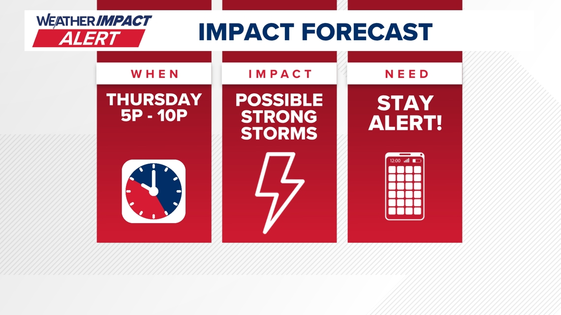
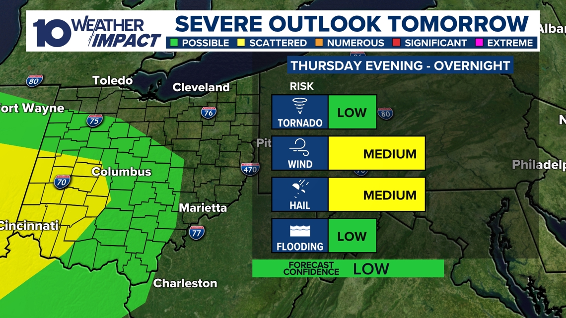
Fast‑Moving Cold Front Triggers Marginal Severe‑Weather Risk fast‑moving cold front is forecast to arrive Thursday, prompting the National Weather Service to issue a Level‑1 marginal severe‑weather risk for wind, hail and an isolated tornado [1]. The 10TV Weather Impact Alert was activated for the afternoon and evening to give the public time to prepare [1]. Atmospheric analysis cites a nearby low‑pressure system, an advancing warm front, and notable wind shear as the primary drivers of the threat [1]. While wind gusts and hail are the main concerns, the possibility of a tornado cannot be ruled out [1].
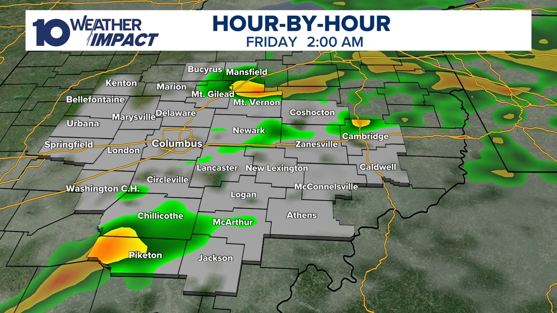
Storms Expected to Peak Early Afternoon Then Diminish The strongest thunderstorms are projected to develop early in the afternoon when daylight and atmospheric energy are greatest [1]. Storm intensity is expected to taper through the evening, with the risk dropping markedly overnight [1]. Heavy rain could accompany the storms, but major flooding is not anticipated [1]. After‑effects include gusty conditions on Friday and a chance of snow showers as early as Sunday [1].
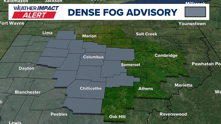
Preceding Dense Fog Advisory Highlighted Hazardous Travel On Tuesday, a Dense Fog Advisory covered central Ohio counties, reducing visibility to a quarter‑mile or less and prompting a 10TV Weather Impact Alert [2]. Forecasters linked the fog to saturated soil from recent snowmelt meeting warmer air moving into the region [2]. Although the fog was thinner than Monday’s, it still created hazardous travel conditions and slick roads [2]. The advisory included resources such as school‑closure updates, interactive radar, and a 10‑day forecast to aid commuters [2].
Sources
-
1.
WBNS: Strong Storms Expected Thursday Afternoon and Evening Across Central Ohio: Highlights warm 60 °F temperatures, an incoming cold front, a Level‑1 marginal severe‑weather risk with wind, hail and possible tornado, peak storm timing, and post‑storm gusty Friday and potential Sunday snow .
-
2.
WBNS: Dense Fog Advisory Triggers Weather Impact Alert for Central Ohio Tuesday: Details the Tuesday dense fog advisory, visibility impacts, meteorological cause, comparison to Monday’s fog, and provides commuter resources while outlining the upcoming warm storm and cooling front .
Timeline
Dec 5, 2025 – Ohio records season‑lowest wind chills as single‑digit temperatures combine with strong winds, driving wind‑chill values below zero; forecasters expect a gradual warm‑up into the 20s‑30s by afternoon and a moderate weekend before a wintry front arrives on Sunday [12].
Dec 9, 2025 – A 10TV Weather Impact Alert warns that a strong Midwest storm brings a rain‑snow mix to morning commuters, with minimal snow accumulation due to near‑freezing temperatures and gusts up to 40 mph; a weaker system is forecast for Friday‑Saturday [11].
Dec 13, 2025 – Saturday’s heavy snowfall deposits up to 9 inches across central Ohio, accompanied by 25 mph winds and wind chills near or below zero on Sunday‑Monday; several counties declare snow emergencies and the NWS issues Cold Weather Advisories [10].
Dec 27, 2025 – A powerful low‑pressure system drives Monday wind gusts of 40‑50 mph statewide, prompting a Wind Advisory and a Weather Impact Alert Day; temperatures plunge into the low‑20s by early Tuesday, raising concerns about power outages and travel disruptions [8].
Dec 28, 2025 – A developing storm system moves into central Ohio Sunday night, bringing rain and thunderstorms with a Level 1 severe‑weather risk and damaging wind gusts near 60 mph; a rapid cold front then drops temperatures from the 60s to the 20s within 12 hours, creating flash‑freeze hazards Monday morning [9].
Dec 31, 2025 – A Weather Impact Alert warns that snow begins after 4 p.m., delivering 1‑3 inches of accumulation and wind chills in the teens while high temperatures remain in the 20s; the event threatens travel for OSU fans and New Year’s Eve celebrations [7].
Jan 1, 2026 – An Impact Alert Day forecasts up to 2 inches of snow (0.5‑1.5 inches typical) with breezy winds and teen‑degree wind chills, coinciding with New Year’s Eve plans and an Ohio State football game; temperatures stay in the 20s before a gradual warm‑up later in the week [6].
Jan 11, 2026 – A northwest airflow ushers in light snow showers overnight into Sunday, producing dustings to 0.5 inch as temperatures sit in the 20s‑low‑30s; strong winds drive wind‑chill values into the 10s‑20s, but sunshine returns Monday‑Tuesday with highs in the 40s [5].
Jan 21, 2026 – A Winter Storm Watch covers six southern counties as an arctic blast drives single‑digit temperatures and subzero wind chills from Friday night through Monday morning; alert days warn of dangerous wind‑chill exposure and the possibility of snow, with the worst wind‑chill impacts Friday night into Saturday [4].
Feb 2, 2026 – Friday’s snowfall blankets central Ohio with 1‑3 inches (up to 4.5 inches locally) and is followed by bitter cold and subzero wind chills; cold‑weather advisories end Saturday as winds calm, setting the stage for a cloudy night with low‑single‑digit lows [3].
Feb 7, 2026 – Sunday brings a slight warm‑up to the mid‑low 20s and an additional 1‑2 inch snow band, while Monday and Tuesday see gradual warming into the 30s‑40s and partly cloudy skies; forecasters note repeated rain or snow chances later in the week as warmer air approaches [3].
Feb 17, 2026 – Dense fog returns Tuesday morning, reducing visibility to a quarter‑mile as cold, moisture‑laden soil meets warm air; the NWS issues a Dense Fog Advisory and forecasters warn of a near‑record 66 °F warm storm later in the week, rain showers Wednesday‑Thursday, a thunderstorm Thursday, a cold front Friday, and snow showers Sunday [2].
Feb 19, 2026 – A fast‑moving cold front triggers strong to severe thunderstorms Thursday afternoon, with a marginal Level‑1 severe‑weather risk focused on wind, hail and an isolated tornado possibility; storms peak early afternoon, then weaken, while gusty Friday weather and a chance of Sunday snow follow the event [1].
Dive deeper (9 sub-stories)
-
Strong Thursday Storms Threaten Central Ohio With Wind, Hail, Possible Tornado
(2 articles)
-
WBNS (Columbus, OH): Dense Fog Advisory Triggers Weather Impact Alert for Central Ohio Tuesday
-
Snow Returns to Central Ohio Friday, Cold Lingers as Forecast Predicts Gradual Warm‑Up
(2 articles)
-
WBNS (Columbus, OH): Central Ohio braces for weekend snow and subzero wind chills as arctic blast returns
-
WBNS (Columbus, OH): Snow showers expected in central Ohio overnight into Sunday as cold air moves in
-
Central Ohio Braces for Up to Two Inches of Snow as Weather Impact Alert Day Begins
(2 articles)
-
WBNS (Columbus, OH): Central Ohio braces for 40-50 mph wind gusts Monday as a strong low pressure system moves through
-
WBNS (Columbus, OH): Rain, snow and wind impacting Wednesday morning commute in central Ohio
-
WBNS (Columbus, OH): Ohio Experiences Record Low Wind Chills on Friday Morning
All related articles (12 articles)
-
WBNS (Columbus, OH): Strong Storms Expected Thursday Afternoon and Evening Across Central Ohio
-
WBNS (Columbus, OH): Dense Fog Advisory Triggers Weather Impact Alert for Central Ohio Tuesday
-
WBNS (Columbus, OH): Snow Returns to Central Ohio as Bitter Cold Lingers, Forecast Calls for Gradual Warm‑up
-
WBNS (Columbus, OH): Central Ohio braces for weekend snow and subzero wind chills as arctic blast returns
-
WBNS (Columbus, OH): Snow showers expected in central Ohio overnight into Sunday as cold air moves in
-
WBNS (Columbus, OH): Central Ohio braces for up to 2 inches of snow as Weather Impact Alert Day is issued
-
WBNS (Columbus, OH): Snow expected this evening across central and southern Ohio with 1-3 inches of accumulation
-
WBNS (Columbus, OH): Central Ohio braces for 40-50 mph wind gusts Monday as a strong low pressure system moves through
-
WBNS (Columbus, OH): Storm system may bring thunderstorms to central Ohio overnight
-
WBNS (Columbus, OH): Sub-zero wind chills Sunday & Monday after heavy snow Saturday
-
WBNS (Columbus, OH): Rain, snow and wind impacting Wednesday morning commute in central Ohio
-
WBNS (Columbus, OH): Ohio Experiences Record Low Wind Chills on Friday Morning
External resources (6 links)
- http://facebook.com/AaronWhiteTV/ (cited 1 times)
- http://facebook.com/MikeBehrensWX (cited 1 times)
- http://instagram.com/MikeBehrensWX (cited 1 times)
- http://instagram.com/aaronwhitetv/ (cited 1 times)
- http://twitter.com/MikeBehrensWX (cited 1 times)
- http://x.com/AaronWhiteTV (cited 1 times)