Central Ohio Faces Thursday Night Storm, Flood Threat and Lingering Winds
Updated (13 articles)
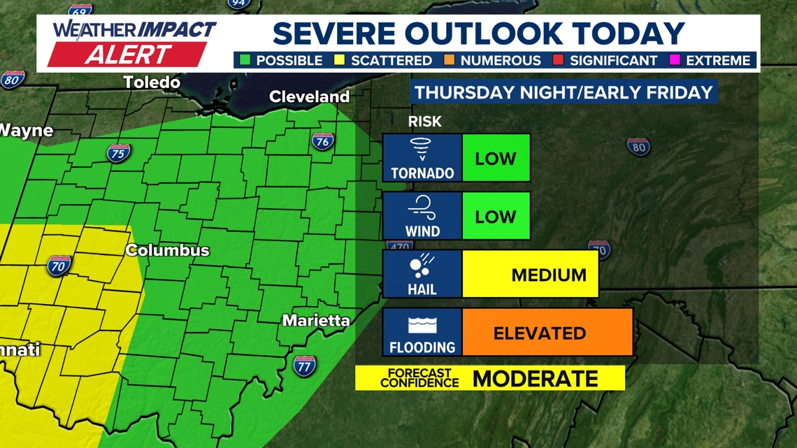
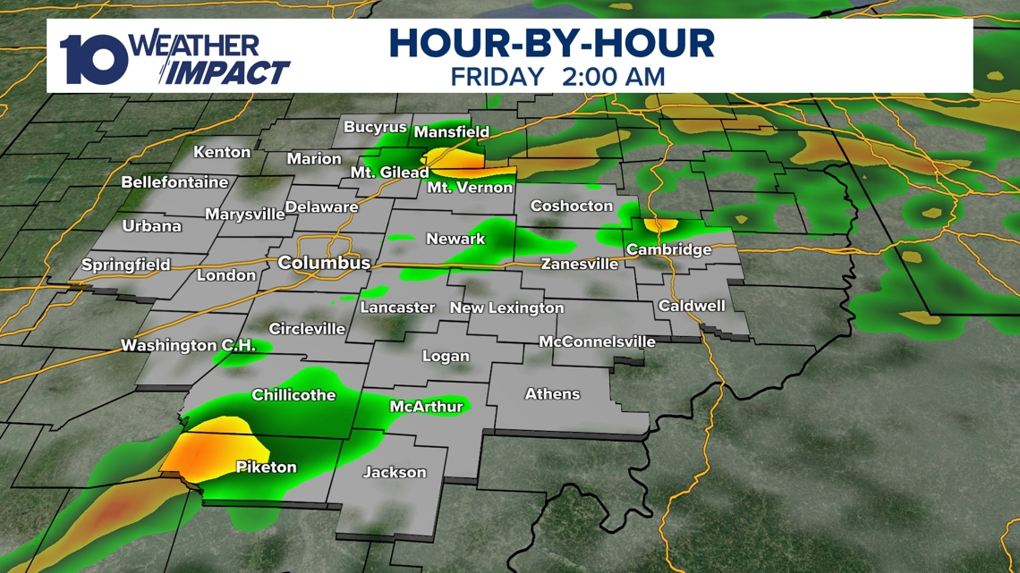
Storm System Arrives Over Central Ohio Thursday Night The low‑pressure system entered central Ohio after producing severe weather to the south and west earlier on Thursday, prompting a 10TV Weather Impact Alert Day that remains in effect through the night [1][2]. Warm, moisture‑laden air surged from the west, fueling showers and thunderstorms that peaked around 9 p.m. [2]. The atmospheric setup—a warm front ahead of a cold front with moderate wind shear—generated a marginal level‑1 of 5 severe‑weather risk, and forecasters did not rule out an isolated tornado [1][2].
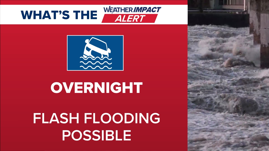
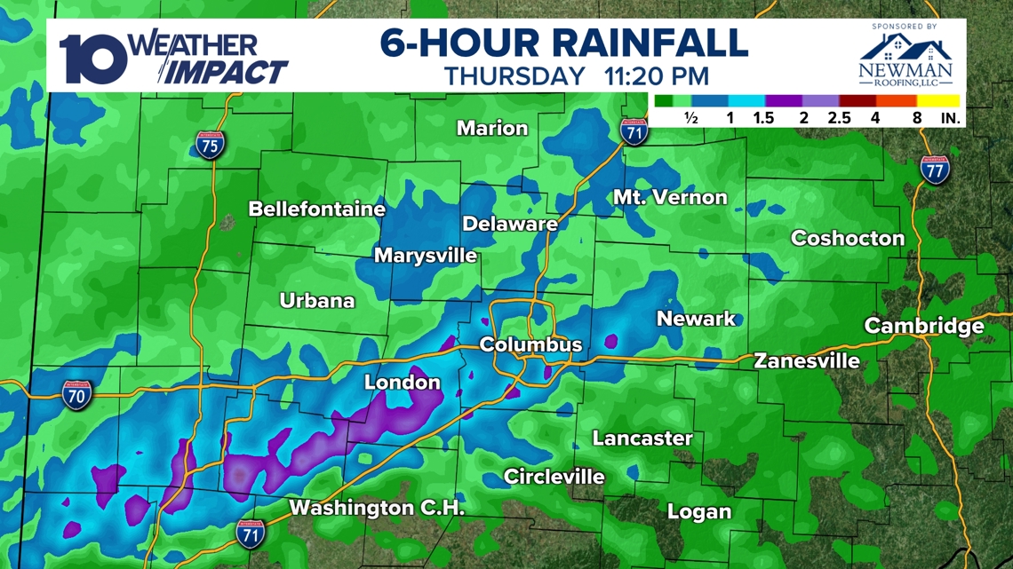
Heavy Rainfall Triggers Flash Flood Warnings Radar estimated rainfall exceeding 2 inches in multiple locations by 11:20 p.m., concentrating the primary threat on flash flooding rather than wind or hail [1][2]. Fayette and Madison counties stayed under flood alerts until 2 a.m., and officials urged caution on roads and in flood‑prone areas [1][2]. Showers and storms are expected to wane before sunrise Friday, though gusty winds will likely persist into the morning, with temperatures dropping and a chance of snow showers by Sunday [1][2].
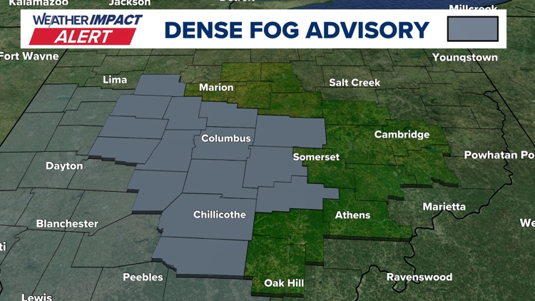
Dense Fog Advisory Preceded Storm, Forecast Calls Cooling Front Dense Fog Advisory issued on Tuesday morning reduced visibility to a quarter‑mile across central Ohio, caused by saturated soil from snowmelt meeting warmer air [3]. Although thinner than Monday’s fog, the advisory still posed hazardous travel conditions and prompted a local Weather Impact Alert Day [3]. Meteorologists forecast a warm storm later in the week with near‑record heat, scattered rain, and thunderstorms, followed by a cold front on Friday that will clear skies and bring cooler temperatures and possible snow showers on Sunday [3].
Sources
-
1.
WBNS: Strong Storm System Brings Severe Weather and Flood Risk to Central Ohio: reports the storm’s Thursday night arrival, 10TV alert, shift to flood risk, >2‑inch rain totals, lingering gusts, and potential snow .
-
2.
WBNS: Strong Storm System Moves Through Central Ohio Thursday Night: emphasizes the 9 p.m. thunderstorm peak, atmospheric conditions creating a level‑1 severe‑weather risk, and flash‑flooding expectations .
-
3.
WBNS: Dense Fog Advisory Triggers Weather Impact Alert for Central Ohio Tuesday: details the fog advisory, its causes, and the week‑long forecast of warm storm, rain, and a cooling front .
Timeline
Dec 5, 2025 – Ohio records unprecedented low wind chills as temperatures dip into the single digits and teens while wind speeds amplify the cold, prompting Cold Weather Advisories and a brief warming forecast into the 20s‑30s later that day[13].
Dec 9‑10, 2025 – A 10TV Weather Impact Alert Day warns of a strong Midwest storm bringing a rain‑snow mix and gusts up to 40 mph that could make morning commutes slippery, while a weaker system is expected to bring light snow Friday into Saturday[12].
Dec 14‑15, 2025 – Snowfall up to 9 inches blankets central Ohio, with winds up to 25 mph creating blowing snow; wind chills hover near or below zero, leading several counties to declare snow emergencies and issue Cold Weather Advisories[11].
Dec 27‑28, 2025 – A developing storm system moves into central Ohio Sunday night, lifting temperatures into the 60s before a sharp cold front drops them to the 20s by Monday noon, creating flash‑freeze risk and a Level 1 severe‑weather threat including possible 60‑mph wind gusts and an isolated tornado[10].
Dec 29, 2025 – A strong low‑pressure system drives Monday wind gusts of 40‑50 + mph across central Ohio, prompting statewide Wind Advisories, warnings of power outages, and a rapid temperature plunge into the low 20s by early Tuesday[9].
Dec 31, 2025 – A Weather Impact Alert warns that snow will begin after 4 p.m., delivering 1‑3 inches of accumulation and wind chills in the teens, while travel to the OSU football game and New Year’s Eve events may be disrupted[8].
Jan 1, 2026 – The 10TV Weather Impact Team issues an Alert Day for up to 2 inches of snow, breezy winds and teens‑level wind chills, targeting travel for the OSU game and New Year’s celebrations; most areas expect 0.5‑1.5 inches before the system exits late tonight[7].
Jan 11, 2026 – A northwest airflow ushers in colder air with temperatures in the 20s‑30s, bringing light snow showers (up to 0.5 in) overnight into Sunday, while strong winds drive wind chills into the 10s‑20s; sunshine returns Monday‑Tuesday with highs in the 40s[6].
Jan 21, 2026 – A Southern Ohio Winter Storm Watch (Athens, Highland, Jackson, Pike, Ross, Scioto) is active from Saturday 7 a.m. to Monday 7 a.m., forecasting subzero wind chills, possible snow, and the worst wind‑chill conditions Friday night into Saturday, prompting multiple Weather Impact Alert Days[5].
Feb 7, 2026 – Snow returns Friday with 1‑3 inches across central Ohio and bitter wind chills; a brief warm‑up follows Sunday with a second snow band adding 1‑2 inches, then temperatures gradually rise into the 30s‑40s by early next week, with repeated rain/snow chances expected later in the week[4].
Feb 17, 2026 – A Dense Fog Advisory triggers a Weather Impact Alert for Tuesday morning as visibility drops to a quarter‑mile; forecasters cite cold, moisture‑laden soil meeting warm air, and note an upcoming windy storm that could bring near‑record 66 °F heat, scattered rain Wednesday‑Thursday, a thunderstorm Thursday, and a cooling front Friday with snow showers Sunday[3].
Feb 20, 2026 (Thursday night) – A strong storm system moves into central Ohio, delivering warm, moist air that fuels thunderstorms around 9 p.m.; radar shows >2 inches of rain, shifting the threat to flash flooding in Fayette and Madison counties and maintaining a marginal Level‑1 severe‑weather risk with an isolated tornado possible; storms are expected to wane before sunrise Friday, with gusty winds lingering into Friday and a chance of snow showers by Sunday[1][2].
Dive deeper (10 sub-stories)
-
Central Ohio Faces Heavy Rain and Flash Flood Threat Thursday Night
(2 articles)
-
WBNS (Columbus, OH): Dense Fog Advisory Triggers Weather Impact Alert for Central Ohio Tuesday
-
Snow Returns to Central Ohio Friday, Cold Lingers as Forecast Predicts Gradual Warm‑Up
(2 articles)
-
WBNS (Columbus, OH): Central Ohio braces for weekend snow and subzero wind chills as arctic blast returns
-
WBNS (Columbus, OH): Snow showers expected in central Ohio overnight into Sunday as cold air moves in
-
Central Ohio Braces for Up to Two Inches of Snow as Weather Impact Alert Day Begins
(2 articles)
-
WBNS (Columbus, OH): Central Ohio braces for 40-50 mph wind gusts Monday as a strong low pressure system moves through
-
WBNS (Columbus, OH): Storm system may bring thunderstorms to central Ohio overnight
-
WBNS (Columbus, OH): Rain, snow and wind impacting Wednesday morning commute in central Ohio
-
WBNS (Columbus, OH): Ohio Experiences Record Low Wind Chills on Friday Morning
All related articles (13 articles)
-
WBNS (Columbus, OH): Strong Storm System Brings Severe Weather and Flood Risk to Central Ohio
-
WBNS (Columbus, OH): Strong Storm System Moves Through Central Ohio Thursday Night
-
WBNS (Columbus, OH): Dense Fog Advisory Triggers Weather Impact Alert for Central Ohio Tuesday
-
WBNS (Columbus, OH): Snow Returns to Central Ohio as Bitter Cold Lingers, Forecast Calls for Gradual Warm‑up
-
WBNS (Columbus, OH): Central Ohio braces for weekend snow and subzero wind chills as arctic blast returns
-
WBNS (Columbus, OH): Snow showers expected in central Ohio overnight into Sunday as cold air moves in
-
WBNS (Columbus, OH): Central Ohio braces for up to 2 inches of snow as Weather Impact Alert Day is issued
-
WBNS (Columbus, OH): Snow expected this evening across central and southern Ohio with 1-3 inches of accumulation
-
WBNS (Columbus, OH): Central Ohio braces for 40-50 mph wind gusts Monday as a strong low pressure system moves through
-
WBNS (Columbus, OH): Storm system may bring thunderstorms to central Ohio overnight
-
WBNS (Columbus, OH): Sub-zero wind chills Sunday & Monday after heavy snow Saturday
-
WBNS (Columbus, OH): Rain, snow and wind impacting Wednesday morning commute in central Ohio
-
WBNS (Columbus, OH): Ohio Experiences Record Low Wind Chills on Friday Morning
External resources (7 links)
- https://www.facebook.com/AaronWhiteTV (cited 2 times)
- https://www.facebook.com/ChrisTomer (cited 2 times)
- https://www.facebook.com/GarofaloWX (cited 2 times)
- https://www.facebook.com/mikebehrenswx (cited 2 times)
- http://facebook.com/AaronWhiteTV/ (cited 1 times)
- http://instagram.com/aaronwhitetv/ (cited 1 times)
- http://x.com/AaronWhiteTV (cited 1 times)