Strong Thursday Storms Threaten Central Ohio With Wind, Hail, Possible Tornado
Updated (51 articles)
Warm Temperatures Set Stage for Thursday’s Severe Weather Central Ohio saw morning rain on Wednesday followed by a surge of warm air that lifted temperatures into the low‑60s, a trend that will persist into Thursday [1]. A fast‑moving cold front is forecast to arrive Thursday, prompting the issuance of a 10TV Weather Impact Alert for the afternoon and evening [1]. The same front is expected to bring scattered rain showers on Wednesday and Thursday, according to the week‑long outlook [2].
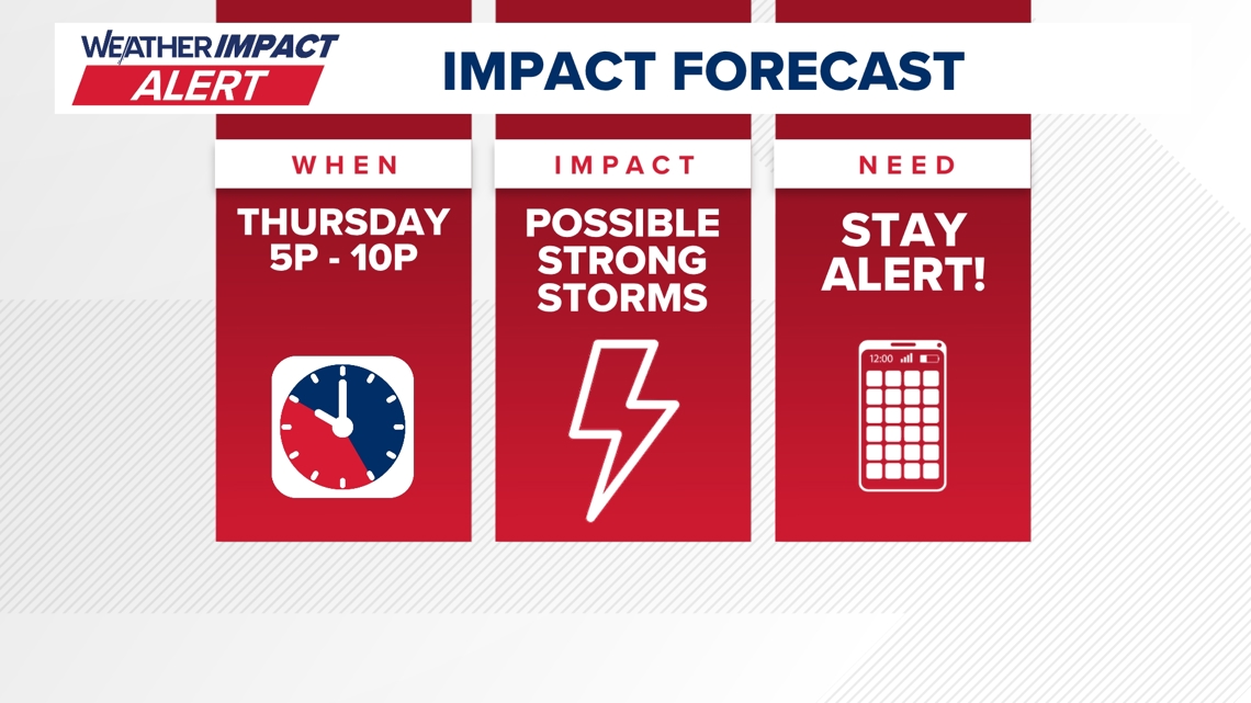
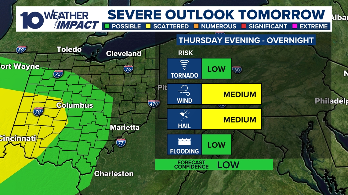
Marginal Severe‑Weather Risk Highlights Wind, Hail, Tornado Potential The Storm Prediction Center assigned a level‑1 marginal risk, driven by a low‑pressure system, an advancing warm front, and strong wind shear [1]. Primary hazards include damaging wind gusts and hail, while forecasters cannot rule out an isolated tornado [1]. This risk aligns with the broader forecast of possible thunderstorms on Thursday [2].
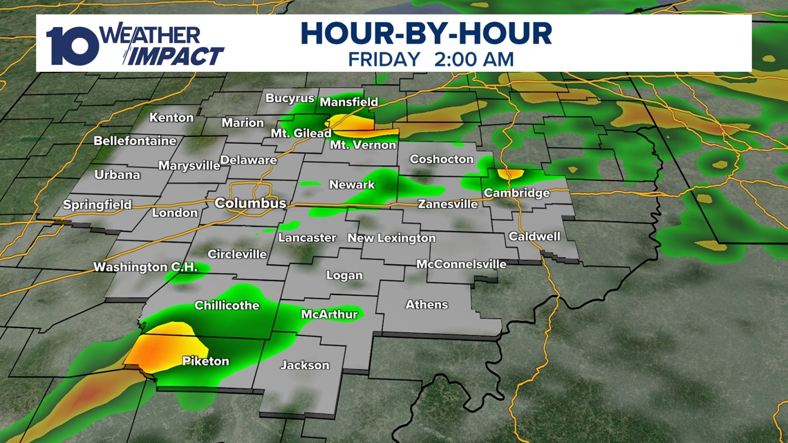
Storm Timing, Rainfall Amounts, and Flooding Outlook The strongest storms are projected to peak in the early afternoon when solar heating is maximal, then weaken through the evening and dissipate overnight [1]. Heavy rain could accompany the storms, but the National Weather Service does not anticipate major flooding [1]. Friday will remain gusty as temperatures drop, and meteorologists note that snow showers could return as early as Sunday [1].
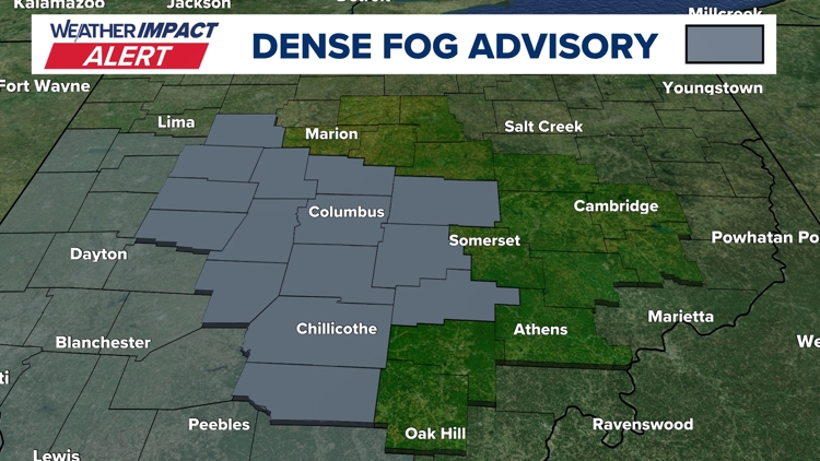
Dense Fog Advisory Demonstrates Rapid Atmospheric Shifts Tuesday morning a Dense Fog Advisory covered central Ohio counties, reducing visibility to a quarter‑mile and prompting a 10TV Weather Impact Alert for hazardous travel [2]. Forecasters linked the fog to saturated soil from recent snowmelt meeting an influx of warmer air [2]. The advisory precedes the same warm‑air surge that will fuel Thursday’s thunderstorms, followed by a cooling front on Friday and possible snow showers on Sunday [2].
Sources
-
1.
WBNS:Strong Storms Expected Thursday Afternoon and Evening Across Central Ohio: Details the Thursday thunderstorm threat, marginal severe‑weather risk, wind and hail hazards, and post‑storm gusty Friday and potential Sunday snow .
-
2.
WBNS:Dense Fog Advisory Triggers Weather Impact Alert for Central Ohio Tuesday: Describes Tuesday’s dense fog, visibility impacts, meteorological cause, and places the fog within a week‑long pattern that includes near‑record warmth, Thursday thunderstorms, Friday cold front, and Sunday snow showers .
Related Tickers
Timeline
Dec 13‑14, 2025 – A winter storm drops 1‑9 inches of snow across central Ohio, setting a new 5.4‑inch record at John Glenn Airport and prompting Level 2 and Level 3 snow‑emergency declarations county‑wide[24].
Dec 15, 2025 – Columbus City Schools cancel Monday classes and extracurriculars because of lingering bitter cold and blowing snow, warning of subzero wind chills[23].
Dec 25, 2025 – Giant Eagle shuts all Ohio stores at 4 p.m. as six inches to nearly a foot of snow fall; every central Ohio county is placed under Level 2 or Level 3 snow emergencies and forecasters warn of continued heavy snow and bitter cold through the week[14].
Dec 25, 2025 – The Ohio Department of Transportation deploys more than 1,200 snow‑clearing crews, places Franklin County under a Level 2 Snow Emergency, and warns that 8‑14 inches of snow could blanket the Columbus metro area[15].
Dec 25, 2025 – Six vehicles become stranded on I‑70 West near US 33 as snow intensifies; the highway reopens after two hours, while a Winter Storm Warning covers all 88 Ohio counties and subzero temperatures with wind chills of –10 °F to –20 °F are forecast[16].
Dec 28, 2025 – A storm system brings rain and thunderstorms Sunday night into Monday, lifting temperatures into the 60s before a sharp 40‑degree drop by Monday noon, creating flash‑freeze risk and a Level 1 severe‑weather outlook for damaging winds up to 60 mph[22].
Jan 1, 2026 – 10TV issues a Weather Impact Alert Day for up to 2 inches of snow, breezy winds and teen‑degree wind chills, coordinating travel advice for the OSU football game and New Year’s Eve celebrations[21].
Jan 16, 2026 – The Columbus Metropolitan Library opens a portion of its main branch as a cold‑weather shelter from noon to 9 p.m., offering Wi‑Fi and restrooms while all other branches close for Martin Luther King Jr. Day; temperatures could dip to 3 °F with wind chills of –5 °F to –15 °F[19].
Jan 16, 2026 – The Columbus Zoo and Aquarium closes Monday due to freezing temperatures, citing safety of guests, staff and animals; the worst cold is expected Monday night into Tuesday morning[20].
Jan 24, 2026 – Mayor Andrew Ginther briefs residents on an approaching major winter storm, announces Snow Warriors will clear 8‑12 inches, a Winter Storm Warning predicts wind chills of –5 °F to –15 °F, and ODOT readies 1,500 trucks and 3,000 drivers for road treatment[17].
Jan 25, 2026 – Giant Eagle again shuts all Ohio stores at 4 p.m. as six inches to nearly a foot of snow fall; the entire central Ohio region remains under Level 2/3 snow emergencies and forecasters warn that bitter cold will linger after the snowfall ends[14].
Jan 25, 2026 – Central Ohio tow operators log roughly 100 service calls on Sunday; Broad & James Towing adds five drivers, calling the event the worst storm in a decade, and notes many stranded motorists are healthcare workers who declined overnight shelter[10].
Jan 25, 2026 – Six cars become stuck on I‑70 West near US 33; the road reopens after two hours, while a statewide Winter Storm Warning remains in effect and subzero temperatures with wind chills of –10 °F to –20 °F are expected[16].
Jan 26, 2026 – The Columbus Blue Jackets postpone their Monday night game vs. the Los Angeles Kings to March 9 because a foot of snow and extreme cold make travel unsafe; tickets stay valid and the next home game moves up to Wednesday vs. the Flyers[12].
Jan 26, 2026 – 10TV extends live winter‑storm coverage as up to 16 inches fall in central Ohio; a Winter Storm Warning stays active through Monday noon and subzero temperatures with wind chills persist all week, prompting widespread school, business and municipal closures[13].
Jan 26, 2026 – Central Ohio declares Level 2 Snow Emergencies across most counties; the Columbus Zoo remains closed through Jan 30, courts close Jan 27, and the storm ranks as the fifth‑biggest snowfall on record for Columbus, with 8‑16 inches reported[11].
Jan 27, 2026 – An Ohio winter storm leaves over 16 inches of snow, triggers Level 2 emergencies in Columbus counties and Level 3 in southern counties, and forces school cancellations for Tuesday; arctic air brings subzero temperatures and wind chills of –10 °F to –20 °F[9].
Jan 28, 2026 – The Columbus Zoo stays closed through Feb 1 as more than 16 inches of snow accumulate, making it the season’s largest and the fifth‑largest storm on record for the city[8].
Jan 29, 2026 – Central Ohio schools shut down Friday amid arctic cold; dozens of districts cancel, wind chills stay at or below zero, and Saturday may tie the Jan 31 record low of –6 °F before Sunday’s subzero mornings end the cold snap[7].
Jan 31, 2026 – Columbus records a new all‑time low of –9 °F at John Glenn Airport, breaking the –6 °F record; wind chills plunge to –30 °F and forecasters predict a gradual warm‑up into the 20s‑30s next week[6].
Feb 1, 2026 – The –9 °F record low is confirmed; snowpack of 8‑16+ inches persists, Canadian arctic air keeps temperatures below 20 °F until the following week, and statewide snow cover is expected to last through the weekend[4][5].
Feb 2, 2026 – Snow returns Friday with 1‑3 inches (up to 4.5 inches locally); bitter cold wind chills remain subzero, Sunday brings a slight warm‑up to the mid‑low 20s and another 1‑2‑inch snow band, while Monday‑Tuesday see highs rise into the 30s‑40s[3].
Feb 7, 2026 – Snow continues Sunday with 1‑2 inches as temperatures climb to the mid‑low 20s; Monday and Tuesday bring gradual warming into the 30s‑40s, and a rain/snow chance may return Wednesday with temperatures near 40 °F[3].
Feb 17, 2026 – Dense fog returns Tuesday morning, reducing visibility to a quarter‑mile; the NWS issues a Dense Fog Advisory, attributing the fog to cold, moisture‑laden soil meeting warm air, and forecasts a warm storm, rain and a cooling front later in the week[2].
Feb 19, 2026 – Warm temperatures linger in the 60s after Wednesday showers; a fast‑moving cold front triggers a marginal severe‑weather risk with wind, hail and a possible tornado, storms peak early Thursday afternoon then weaken, and gusty Friday weather and possible Sunday snow are expected[1].
Dive deeper (10 sub-stories)
-
Warm Front Pushes Temperatures to 60s Before Thursday Severe Thunderstorm Threat
(12 articles)
-
Columbus Hits Record –9°F as Snowpack Deepens, Cold Wave Extends Through Weekend
(3 articles)
-
Central Ohio Schools Set to Reopen Monday After Record Snowstorm and Arctic Freeze
(17 articles)
-
WBNS (Columbus, OH): Central Ohio Schools Remain Closed as Winter Storm Extends to Fifth Day
-
Columbus Zoo Extends Shutdown to Feb. 1 After Record Snowstorm
(3 articles)
-
Ohio Winter Storm Dumps Up to 20 Inches, Triggers County Emergencies and School Closures
(9 articles)
-
WBNS (Columbus, OH): Central Ohio Towing Services Overwhelmed After Heavy Snowfall
-
WBNS (Columbus, OH): Columbus Blue Jackets game postponed to March 9 after heavy snowstorm
-
Ohio Endures Record Snowfall as Winter Storm Persists Through Monday
(2 articles)
-
Kroger and Giant Eagle Shut Hundreds of Ohio Stores Early as Snowstorm Deepens
(2 articles)
All related articles (51 articles)
-
WBNS (Columbus, OH): Strong Storms Expected Thursday Afternoon and Evening Across Central Ohio
-
WBNS (Columbus, OH): Dense Fog Advisory Triggers Weather Impact Alert for Central Ohio Tuesday
-
WBNS (Columbus, OH): Snow Returns to Central Ohio as Bitter Cold Lingers, Forecast Calls for Gradual Warm‑up
-
WBNS (Columbus, OH): Columbus Endures Record Cold as Snowpack Persists, Warmer Weather Expected Next Week
-
WBNS (Columbus, OH): Columbus Record Low and Snowpack Keep Central Ohio in Deep Freeze
-
WBNS (Columbus, OH): Columbus Sets New Record Low Temperature of –9°F
-
WBNS (Columbus, OH): Central Ohio Schools Set to Reopen After Snow‑Related Week‑Long Closures
-
WBNS (Columbus, OH): Central Ohio Schools Remain Closed as Winter Storm Extends to Fifth Day
-
WBNS (Columbus, OH): Columbus City Schools Cancel Classes Friday Amid Ongoing Winter Storm and Extreme Cold
-
WBNS (Columbus, OH): Central Ohio Schools Shut Down Friday Amid Arctic Cold
-
WBNS (Columbus, OH): Columbus Zoo Remains Closed Through Feb. 1 Amid Record Snow and Subzero Cold
-
WBNS (Columbus, OH): Central Ohio School Districts Cancel Thursday Classes Amid Arctic Cold
-
WBNS (Columbus, OH): Central Ohio School Districts Close Wednesday Amid Deep Freeze
-
WBNS (Columbus, OH): Ohio Winter Storm Leaves Over 16 Inches of Snow and Triggers Snow Emergencies
-
WBNS (Columbus, OH): Central Ohio Receives Up to 20 Inches of Snow as Major Winter Storm Ends
-
WBNS (Columbus, OH): Central Ohio Towing Services Overwhelmed After Heavy Snowfall
-
WBNS (Columbus, OH): Central Ohio Business and School Closures After Record Snowstorm
-
WBNS (Columbus, OH): Central Ohio School Districts Close Tuesday Amid Heavy Snow and Arctic Cold
-
WBNS (Columbus, OH): Columbus Blue Jackets game postponed to March 9 after heavy snowstorm
-
WBNS (Columbus, OH): Central Ohio schools close Monday as historic snowstorm brings extreme cold
-
WBNS (Columbus, OH): 10TV Extends Live Winter Storm Coverage Across Ohio
-
WBNS (Columbus, OH): Kroger and Giant Eagle close stores early Sunday as Ohio winter storm intensifies
-
WBNS (Columbus, OH): Ohio State cancels in‑person classes Monday‑Tuesday as winter storm hits central Ohio
-
WBNS (Columbus, OH): Giant Eagle Closes All Ohio Stores Early Amid Snowstorm
-
WBNS (Columbus, OH): Ohio Snowstorm Forces Road Closures and Massive Plow Deployment
-
WBNS (Columbus, OH): Cars stuck on I‑70 West as snow intensifies, highways reopen
-
WBNS (Columbus, OH): Columbus Mayor Updates Residents Ahead of Major Winter Storm
-
WBNS (Columbus, OH): DeWine and state officials urge caution as winter storm looms over central Ohio
-
WBNS (Columbus, OH): Central Ohio braces for weekend snow and subzero wind chills as arctic blast returns
-
WBNS (Columbus, OH): Central Ohio schools cancel or delay Tuesday classes amid extreme cold
-
WBNS (Columbus, OH): Columbus Metropolitan Library opens main branch Monday as cold shelter
-
WBNS (Columbus, OH): Columbus Zoo closes Monday amid freezing temperatures
-
WBNS (Columbus, OH): Snow showers expected in central Ohio overnight into Sunday as cold air moves in
-
WBNS (Columbus, OH): Central Ohio braces for up to 2 inches of snow as Weather Impact Alert Day is issued
-
WBNS (Columbus, OH): Snow expected this evening across central and southern Ohio with 1-3 inches of accumulation
-
WBNS (Columbus, OH): Central Ohio braces for 40-50 mph wind gusts Monday as a strong low pressure system moves through
-
WBNS (Columbus, OH): Storm system may bring thunderstorms to central Ohio overnight
-
WBNS (Columbus, OH): Central Ohio schools closed or delayed amid winter weather
-
WBNS (Columbus, OH): Central Ohio school closings: Several districts cancel or delay Monday classes due to winter weather
-
WBNS (Columbus, OH): Columbus City Schools cancels classes, extracurriculars Monday due to inclement weather
-
WBNS (Columbus, OH): Sub-zero wind chills Sunday & Monday after heavy snow Saturday
-
WBNS (Columbus, OH): Winter storm brings several inches of snow to central Ohio: Current snowfall totals
-
WBNS (Columbus, OH): Columbus City Schools cancels some extracurriculars Saturday due to winter weather
-
WBNS (Columbus, OH): Rain, snow and wind impacting Wednesday morning commute in central Ohio
-
WBNS (Columbus, OH): Ohio Experiences Record Low Wind Chills on Friday Morning
-
WBNS (Columbus, OH): Central Ohio Faces Single‑Digit Wind Chill Friday Morning
-
WBNS (Columbus, OH): Columbus, Ohio Receives 3‑6 Inches of Snow After Winter Storm
-
WBNS (Columbus, OH): Central Ohio Receives Up to 5 inches of Snow Tuesday Morning
-
WBNS (Columbus, OH): Franklin County Courts Closed Tuesday Due to Winter Weather
-
WBNS (Columbus, OH): Central Ohio Schools and Courts Cancel Classes and Close on Tuesday Due to Snow
-
WBNS (Columbus, OH): Columbus City Schools Cancel Tuesday Classes Amid Overnight Snow
External resources (23 links)
- https://warriorwatch.columbus.gov/ (cited 2 times)
- http://emergency.osu.edu (cited 1 times)
- https://twitter.com/hashtag/ODOTwinter?src=hash&ref_src=twsrc%5Etfw (cited 3 times)
- http://facebook.com/AaronWhiteTV/ (cited 2 times)
- http://instagram.com/aaronwhitetv/ (cited 2 times)
- http://x.com/AaronWhiteTV (cited 2 times)
- http://facebook.com/MikeBehrensWX (cited 1 times)
- http://instagram.com/MikeBehrensWX (cited 1 times)
- http://twitter.com/MikeBehrensWX (cited 1 times)
- https://t.co/D3AfQbTt0n (cited 1 times)
- https://t.co/kZTfz0pmJJ (cited 1 times)
- https://t.co/y2mdfitzGi (cited 1 times)
- https://t.co/zE47OTcGJ2 (cited 1 times)
- https://www.facebook.com/ColumbusCitySchools (cited 1 times)
- https://www.facebook.com/ohiodrc/posts/pfbid0eQwq1EC4PRv1zc6YYTEmCVgTZEWanfusM6nZS1LEJBYcNYKc6utcpBPJUZK6TCHpl (cited 1 times)
- https://www.facebook.com/photo/?fbid=1539829818143817&set=a.542568367869972 (cited 1 times)
- https://www.facebook.com/share/p/17aHwhEg5Q/ (cited 1 times)
- https://www.facebook.com/share/p/17vsgKJoM9/ (cited 1 times)
- https://www.facebook.com/share/p/188JhExC1c/ (cited 1 times)
- https://portal.snowpaths.com/public/983278/983279 (cited 2 times)
- https://provolleyball.com/news/2026/01/atlanta-at-columbus-mlv-match-postponed (cited 1 times)
- https://snowgo.dublin.oh.us/ (cited 1 times)
- https://tv.10tv.com/ (cited 1 times)