Ohio Storm System Shifts South, Alert Withdrawn, Leaving Only Light Precipitation Expected
Updated (63 articles)
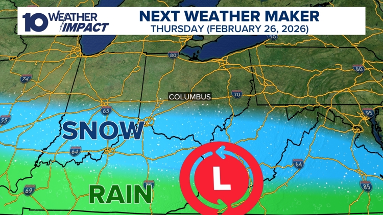
Alert withdrawn as system moves southward The 10 Weather Impact team canceled Thursday’s Weather Impact Alert after model ensembles showed the storm tracking well south of central Ohio, sparing most of the region from significant wintry weather [1]. Forecasts now limit precipitation to brief rain or snow showers south of I‑70, with no accumulation expected. Officials will monitor for any northward re‑track and issue updates if needed [1].
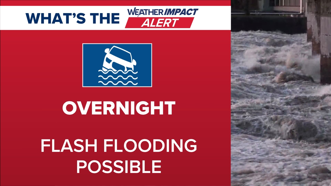
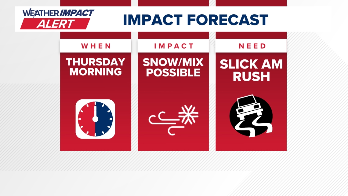
Snow remnants and school disruptions linger Overnight snow on February 23 left slick roads and prompted a 10 Weather Impact Alert for Monday morning travel hazards [2][3]. More than 100 school districts either closed or delayed classes by two hours as temperatures hovered at or below freezing with gusty winds driving wind‑chill values into the teens and low‑20s [2][3]. An additional half‑inch of snow was forecast for the afternoon, keeping bridge decks and overpasses icy [2][3].
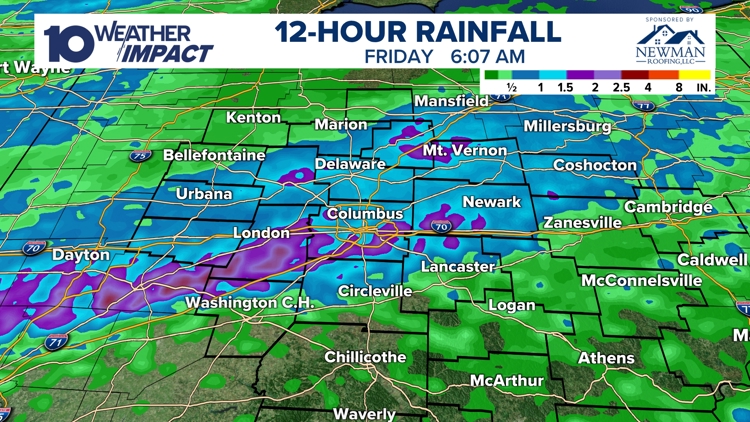
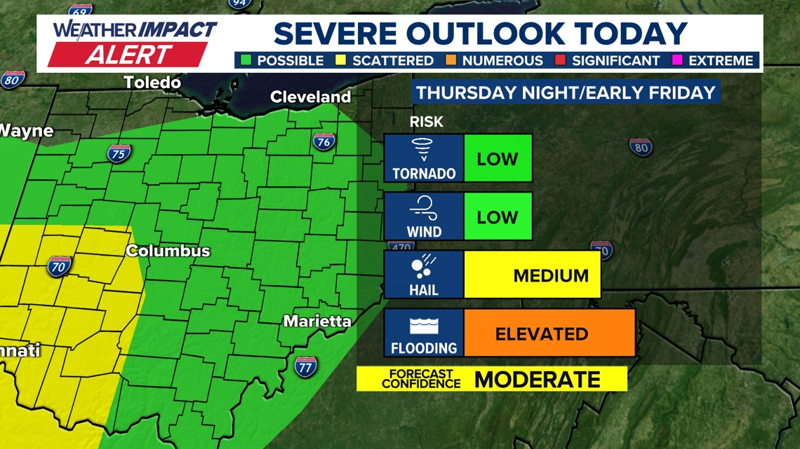
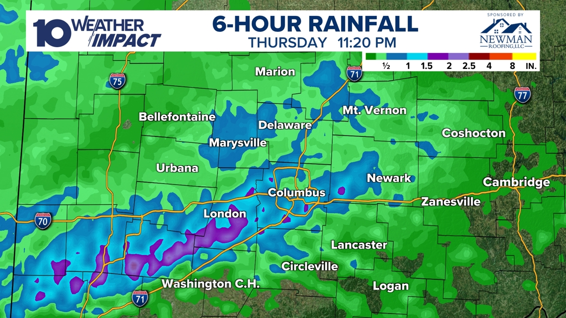
Heavy rain and flash flooding earlier in the week strong storm system on February 20 produced over 2 inches of rain in several locations, generating flash‑flooding with totals such as 1.76 in in Newark and 1.68 in in Columbus [4][5][6]. Raccoon Creek near Granville reached minor flood stage, and a marginal level‑1 severe‑weather risk included isolated tornado potential before the threat shifted to flooding overnight [5][6]. A cold front followed, bringing wind gusts above 40 mph and a sharp temperature drop [4].
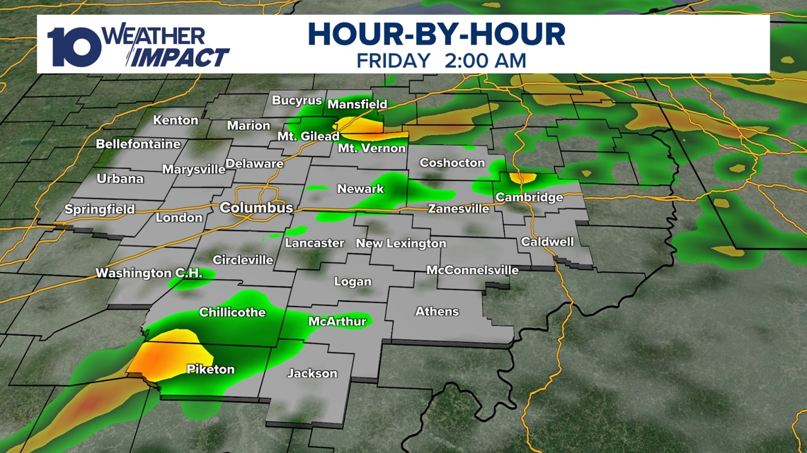
Mid‑week warming and possible Sunday snow Meteorologists expect daytime highs to climb into the 40 °F range by mid‑next week, easing travel concerns [2]. Snow showers are anticipated on Sunday as the system’s moisture returns, while another rain chance is not expected until the following week [4]. Gusty winds may linger into Friday, but storms should wane before sunrise [5][6].
Sources
-
1.
WBNS (Columbus, OH): Ohio Storm System Shifts South, Reducing Thursday Impact – Reports alert withdrawal and southward shift limiting precipitation to light rain or snow south of I‑70 .
-
2.
WBNS (Columbus, OH): Ohio Snow Slows, Roads Remain Slick, Schools Delayed – Details lingering snow, icy roads, over 100 school closures/delays, and sub‑freezing gusty conditions .
-
3.
WBNS (Columbus, OH): Snow clearing this afternoon after slick roads and school delays – Mirrors February 23 snow impacts, alert activation, and continued freezing temperatures .
-
4.
WBNS (Columbus, OH): Heavy Rainfall Triggers Flash Floods and Minor River Rises in Ohio – Highlights >2 inches rain, flash flooding, Raccoon Creek minor flood stage, and upcoming cold front .
-
5.
WBNS (Columbus, OH): Strong Storm System Brings Severe Weather and Flood Risk to Central Ohio – Describes severe thunderstorm risk, marginal level‑1 tornado possibility, and rainfall exceeding 2 inches .
-
6.
WBNS (Columbus, OH): Strong Storm System Moves Through Central Ohio Thursday Night – Provides similar severe‑weather and flooding details, emphasizing warm moist air and flash‑flood potential .
Related Tickers
Timeline
Dec 1, 2025 – A fast‑moving winter storm delivers the season’s first widespread snow to the interior Northeast and New York, dumping up to 10 inches in some spots and prompting a Level 3 Snow Emergency in Hocking County, Ohio; Governor Andy Beshear posts a photo of the snow‑covered mansion and urges residents to “drive slowly” on slick roads [1].
Dec 2, 2025 – The nor’easter pushes into the Northeast, bringing heavy snow and icy roads to New York and Pennsylvania while a tractor‑trailer driver is rescued from a bridge in West Virginia; Governors Kathy Hochul and Janet Mills advise residents to avoid travel [2].
Dec 2, 2025 – Ohio DOT mobilizes 150 snow‑plow crews for the first statewide snow event of the season, pre‑treating roads and warning motorists to allow extra travel time as “accidents are a leading cause of power outages” [30].
Dec 2, 2025 – Central Ohio receives 3‑5 inches of snow Tuesday morning, prompting the lifting of winter weather advisories but flagging an approaching new system [26].
Dec 2, 2025 – Columbus City Schools cancel Tuesday classes after overnight snow makes roads hazardous, joining dozens of district closures across the region [27].
Dec 2, 2025 – Additional school districts, Columbus State Community College, and Franklin County courts close on Tuesday as snow accumulates 2‑4 inches and Snow Emergency levels range from 1 to 3 [28][29].
Dec 5, 2025 – Parts of Ohio record record‑low wind chills, with temperatures in the single digits and wind‑chill values plunging well below 0 °F, though forecasts call for a gradual warm‑up into the 20s‑30s later that day [25].
Dec 10, 2025 – A 10 TV Weather Impact Alert warns of a rain‑snow mix and gusts up to 40 mph on Wednesday, creating slippery roads despite near‑freezing temperatures [24].
Dec 14, 2025 – After a heavy Saturday snowfall of up to 9 inches, sub‑zero wind chills and blowing snow persist Sunday‑Monday, prompting snow emergencies in Franklin, Fairfield and Delaware counties [23].
Dec 15, 2025 – Columbus City Schools cancel Monday classes and extracurriculars as “snow from Saturday” leaves a foot of snow and an Extreme Cold Warning with wind chills near ‑25 °F remains in effect [22].
Dec 20, 2025 – Forecasts call for a near‑60 °F high on Christmas Day in Columbus, which would rank among the city’s top‑10 warmest Christmases, while scattered rain is expected Dec 24‑26 [21].
Dec 31, 2025 – A Weather Impact Alert warns of 1‑3 inches of snow after 4 p.m., targeting OSU game travel and New Year’s Eve plans; winds produce teen‑degree wind chills [20].
Jan 1, 2026 – Central Ohio could see up to 2 inches of snow tonight, with 0.5‑1.5 inches expected on average; the alert ties to OSU game travel and New Year’s Eve celebrations [19].
Jan 11, 2026 – A cold northwest airflow drops temperatures into the 20s overnight, bringing a dusting to half‑inch of snow showers and wind chills in the teens‑20s; sunshine returns with 40 °F highs on Monday and Tuesday [18].
Jan 16, 2026 – The Columbus Metropolitan Library opens a portion of its main branch as a cold‑weather shelter from noon to 9 p.m., offering Wi‑Fi and restrooms while all other branches close for Martin Luther King Jr. Day [16].
Jan 16, 2026 – The Columbus Zoo and Aquarium closes Monday, stating “safety and health of guests, staff and animals is our top priority” amid freezing temperatures [17].
Jan 21, 2026 – A Winter Storm Watch covers six southern Ohio counties, forecasting subzero wind chills and possible snow Saturday‑Monday; the 10 Weather Impact Team issues Alert Days for the weekend [15].
Jan 24, 2026 – Gov. Mike DeWine declares a state of emergency ahead of a major winter storm, authorizing rapid procurement of supplies and urging residents to “stay home unless necessary” as up to 12 inches of snow and subzero temps threaten the region [14].
Jan 25, 2026 – Ohio’s road‑clearing effort deploys over 1,200 crews, with ODOT updates on I‑71 and I‑75 conditions; officials warn drivers to give plows space as snowfall could rank among Columbus’s top five historic events [13].
Jan 25, 2026 – Kroger shuts 115 Columbus‑area stores at 6 p.m. and Giant Eagle closes at 4 p.m. on Sunday as heavy snow (6‑12 inches) and bitter cold continue; a Level 3 snow emergency covers every central Ohio county [12].
Jan 26, 2026 – Columbus records a new low of ‑9 °F, breaking the previous record, while snowpack reaches 8‑16+ inches statewide, reinforcing the deep freeze and delaying warming [7].
Jan 26, 2026 – Central Ohio school districts cancel Monday classes after a historic storm drops over 16 inches of snow—the fifth‑largest on record for Columbus—and subzero wind chills persist through the week [11].
Jan 27, 2026 – More than a dozen central Ohio districts close Wednesday, citing 8‑16+ inches of snow and an extreme‑cold forecast that keeps temperatures below 20 °F all week [10].
Jan 28, 2026 – Ten districts, including Columbus City Schools and Olentangy, cancel Thursday classes as Arctic air drives wind chills to ‑15 °F or lower, though overall weather remains quiet with modest warming early next week [9].
Jan 29, 2026 – Columbus City Schools cancel Friday classes, marking the fifth consecutive day without school; an Extreme Cold Warning remains in effect with wind chills down to ‑25 °F and snow totals of 8‑16 inches [8].
Feb 2, 2026 – Snow returns to central Ohio Friday, delivering 1‑3 inches (4.5‑inches in spots) and bitter wind chills; forecasters project a gradual warm‑up to the 30s‑40s early next week [6].
Feb 20, 2026 – Snow winds down across Ohio, leaving slick roads and prompting a 10 Weather Impact Alert; over 100 school districts delay or close Monday, while an additional 0.5 inch of snow is expected and temperatures rise to the 40s by mid‑week [4][5].
Feb 23, 2026 – A weak moisture band reaches Ohio, generating scattered snow showers and keeping roads icy; the 10 Weather Impact team notes that warmer 40‑degree highs return by mid‑next week [4][5].
Feb 24, 2026 – Models shift the storm southward, leading the 10 Weather Impact team to withdraw the Thursday Weather Impact Alert and expect only brief light rain or snow south of I‑70, with no major accumulation anticipated [3].
Dive deeper (14 sub-stories)
-
Central Ohio Braces for Thursday Storm Bringing Heavy Rain, Flood Threats, and Wintry Mix
(14 articles)
-
Ohio Snow Slows, Roads Remain Slick While Schools Delay; Clearing Expected Afternoon
(19 articles)
-
WBNS (Columbus, OH): Heavy Rainfall Triggers Flash Floods and Minor River Rises in Ohio
-
Columbus Hits Record –9°F as Snowpack Deepens, Cold Wave Extends Through Weekend
(3 articles)
-
WBNS (Columbus, OH): Central Ohio Schools Remain Closed as Winter Storm Extends to Fifth Day
-
Columbus Zoo Extends Shutdown to Feb. 1 After Record Snowstorm
(3 articles)
-
Ohio Winter Storm Dumps Up to 20 Inches, Triggers County Emergencies and School Closures
(9 articles)
-
WBNS (Columbus, OH): Central Ohio Towing Services Overwhelmed After Heavy Snowfall
-
DeWine Urges Precautions as Arctic Cold Persists After State‑wide Emergency Declaration
(2 articles)
-
Ohio Endures Record Snowfall as Winter Storm Persists Through Monday
(2 articles)
-
Kroger and Giant Eagle Shut Hundreds of Ohio Stores Early as Snowstorm Deepens
(2 articles)
-
Ohio Prepares Massive Snow Response as Major Winter Storm Approaches Jan 22
(2 articles)
-
Warm Christmas Week Forecast Brings Near‑60°F Temperatures and Mild Conditions
(2 articles)
-
Dec 2 2025 Nor’easter Brings First Seasonal Snow, Fatalities and State Emergencies
(2 articles)
All related articles (63 articles)
-
WBNS (Columbus, OH): Ohio Storm System Shifts South, Reducing Thursday Impact
-
WBNS (Columbus, OH): Ohio Snow Slows, Roads Remain Slick, Schools Delayed
-
WBNS (Columbus, OH): Snow clearing this afternoon after slick roads and school delays
-
WBNS (Columbus, OH): Heavy Rainfall Triggers Flash Floods and Minor River Rises in Ohio
-
WBNS (Columbus, OH): Strong Storm System Brings Severe Weather and Flood Risk to Central Ohio
-
WBNS (Columbus, OH): Strong Storm System Moves Through Central Ohio Thursday Night
-
WBNS (Columbus, OH): Dense Fog Advisory Triggers Weather Impact Alert for Central Ohio Tuesday
-
WBNS (Columbus, OH): Snow Returns to Central Ohio as Bitter Cold Lingers, Forecast Calls for Gradual Warm‑up
-
WBNS (Columbus, OH): Columbus Endures Record Cold as Snowpack Persists, Warmer Weather Expected Next Week
-
WBNS (Columbus, OH): Columbus Record Low and Snowpack Keep Central Ohio in Deep Freeze
-
WBNS (Columbus, OH): Columbus Sets New Record Low Temperature of –9°F
-
WBNS (Columbus, OH): Central Ohio Schools Set to Reopen After Snow‑Related Week‑Long Closures
-
WBNS (Columbus, OH): Central Ohio Schools Remain Closed as Winter Storm Extends to Fifth Day
-
WBNS (Columbus, OH): Columbus City Schools Cancel Classes Friday Amid Ongoing Winter Storm and Extreme Cold
-
WBNS (Columbus, OH): Central Ohio Schools Shut Down Friday Amid Arctic Cold
-
WBNS (Columbus, OH): Columbus Zoo Remains Closed Through Feb. 1 Amid Record Snow and Subzero Cold
-
WBNS (Columbus, OH): Central Ohio School Districts Cancel Thursday Classes Amid Arctic Cold
-
WBNS (Columbus, OH): Central Ohio School Districts Close Wednesday Amid Deep Freeze
-
WBNS (Columbus, OH): Ohio Winter Storm Leaves Over 16 Inches of Snow and Triggers Snow Emergencies
-
WBNS (Columbus, OH): Central Ohio Receives Up to 20 Inches of Snow as Major Winter Storm Ends
-
WBNS (Columbus, OH): Central Ohio Towing Services Overwhelmed After Heavy Snowfall
-
WBNS (Columbus, OH): Ohio Gov. DeWine urges safety measures as Arctic cold grips state
-
WBNS (Columbus, OH): Central Ohio Business and School Closures After Record Snowstorm
-
WBNS (Columbus, OH): Central Ohio School Districts Close Tuesday Amid Heavy Snow and Arctic Cold
-
WBNS (Columbus, OH): Central Ohio schools close Monday as historic snowstorm brings extreme cold
-
WBNS (Columbus, OH): 10TV Extends Live Winter Storm Coverage Across Ohio
-
WBNS (Columbus, OH): Kroger and Giant Eagle close stores early Sunday as Ohio winter storm intensifies
-
WBNS (Columbus, OH): Ohio State cancels in‑person classes Monday‑Tuesday as winter storm hits central Ohio
-
WBNS (Columbus, OH): Giant Eagle Closes All Ohio Stores Early Amid Snowstorm
-
WBNS (Columbus, OH): Ohio Snowstorm Forces Road Closures and Massive Plow Deployment
-
WBNS (Columbus, OH): Cars stuck on I‑70 West as snow intensifies, highways reopen
-
WBNS (Columbus, OH): Ohio Governor Declares State of Emergency Ahead of Major Winter Storm
-
WBNS (Columbus, OH): Columbus Mayor Updates Residents Ahead of Major Winter Storm
-
WBNS (Columbus, OH): DeWine and state officials urge caution as winter storm looms over central Ohio
-
WBNS (Columbus, OH): ODOT, OSHP urge caution ahead of major winter storm in Ohio
-
WBNS (Columbus, OH): Central Ohio braces for weekend snow and subzero wind chills as arctic blast returns
-
WBNS (Columbus, OH): Central Ohio schools cancel or delay Tuesday classes amid extreme cold
-
WBNS (Columbus, OH): Columbus Metropolitan Library opens main branch Monday as cold shelter
-
WBNS (Columbus, OH): Columbus Zoo closes Monday amid freezing temperatures
-
WBNS (Columbus, OH): Snow showers expected in central Ohio overnight into Sunday as cold air moves in
-
WBNS (Columbus, OH): Central Ohio braces for up to 2 inches of snow as Weather Impact Alert Day is issued
-
WBNS (Columbus, OH): Snow expected this evening across central and southern Ohio with 1-3 inches of accumulation
-
WBNS (Columbus, OH): Central Ohio braces for 40-50 mph wind gusts Monday as a strong low pressure system moves through
-
WBNS (Columbus, OH): Storm system may bring thunderstorms to central Ohio overnight
-
WBNS (Columbus, OH): Winter season begins with solstice as Columbus forecasts mild Christmas week
-
WBNS (Columbus, OH): Columbus Christmas Day could reach 60 F, entering top-10 warmest records
-
WBNS (Columbus, OH): Central Ohio schools closed or delayed amid winter weather
-
WBNS (Columbus, OH): Central Ohio school closings: Several districts cancel or delay Monday classes due to winter weather
-
WBNS (Columbus, OH): Columbus City Schools cancels classes, extracurriculars Monday due to inclement weather
-
WBNS (Columbus, OH): Sub-zero wind chills Sunday & Monday after heavy snow Saturday
-
WBNS (Columbus, OH): Winter storm brings several inches of snow to central Ohio: Current snowfall totals
-
WBNS (Columbus, OH): Columbus City Schools cancels some extracurriculars Saturday due to winter weather
-
WBNS (Columbus, OH): Rain, snow and wind impacting Wednesday morning commute in central Ohio
-
WBNS (Columbus, OH): Ohio Experiences Record Low Wind Chills on Friday Morning
-
WBNS (Columbus, OH): Central Ohio Faces Single‑Digit Wind Chill Friday Morning
-
Newsweek: Winter Storm Continues to Impact Northeast, Snowfall Begins in New York and Pennsylvania
-
CNN: Winter storm delivers first widespread snow of season to the Northeast
-
WBNS (Columbus, OH): Columbus, Ohio Receives 3‑6 Inches of Snow After Winter Storm
-
WBNS (Columbus, OH): Central Ohio Receives Up to 5 inches of Snow Tuesday Morning
-
WBNS (Columbus, OH): Franklin County Courts Closed Tuesday Due to Winter Weather
-
WBNS (Columbus, OH): Central Ohio Schools and Courts Cancel Classes and Close on Tuesday Due to Snow
-
WBNS (Columbus, OH): Columbus City Schools Cancel Tuesday Classes Amid Overnight Snow
-
WBNS (Columbus, OH): ODOT Mobilizes 150 Crews for First Statewide Snow Event of 2025
External resources (30 links)
- https://warriorwatch.columbus.gov/ (cited 2 times)
- https://www.mshp.dps.missouri.gov/HP68/AccidentDetailsAction?ACC_RPT_NUM=250550887 (cited 2 times)
- http://emergency.osu.edu (cited 1 times)
- http://instagram.com/aaronwhitetv/ (cited 5 times)
- http://facebook.com/AaronWhiteTV/ (cited 4 times)
- http://x.com/AaronWhiteTV (cited 4 times)
- https://twitter.com/hashtag/ODOTwinter?src=hash&ref_src=twsrc%5Etfw (cited 3 times)
- https://www.facebook.com/ChrisTomer (cited 3 times)
- https://www.facebook.com/GarofaloWX (cited 3 times)
- https://www.facebook.com/mikebehrenswx (cited 3 times)
- https://www.facebook.com/AaronWhiteTV (cited 2 times)
- https://www.facebook.com/AaronWhiteTV/ (cited 2 times)
- https://www.facebook.com/hockingcommissioners/ (cited 2 times)
- https://www.facebook.com/share/p/17YDkLuULD/ (cited 2 times)
- https://x.com/NWSCLE/status/1995893102620352798 (cited 2 times)
- http://x.com/aaronwhitetv (cited 1 times)
- https://t.co/D3AfQbTt0n (cited 1 times)
- https://t.co/kZTfz0pmJJ (cited 1 times)
- https://t.co/y2mdfitzGi (cited 1 times)
- https://t.co/zE47OTcGJ2 (cited 1 times)
- https://www.facebook.com/ColumbusCitySchools (cited 1 times)
- https://www.facebook.com/ohiodrc/posts/pfbid0eQwq1EC4PRv1zc6YYTEmCVgTZEWanfusM6nZS1LEJBYcNYKc6utcpBPJUZK6TCHpl (cited 1 times)
- https://www.facebook.com/photo/?fbid=1539829818143817&set=a.542568367869972 (cited 1 times)
- https://www.facebook.com/share/p/17aHwhEg5Q/ (cited 1 times)
- https://www.facebook.com/share/p/17vsgKJoM9/ (cited 1 times)
- https://www.facebook.com/share/p/188JhExC1c/ (cited 1 times)
- https://portal.snowpaths.com/public/983278/983279 (cited 2 times)
- https://provolleyball.com/news/2026/01/atlanta-at-columbus-mlv-match-postponed (cited 1 times)
- https://snowgo.dublin.oh.us/ (cited 1 times)
- https://tv.10tv.com/ (cited 1 times)