Central Ohio Braces for Thursday Storm Bringing Heavy Rain, Flood Threats, and Wintry Mix
Updated (14 articles)
Storm System Enters Central Ohio Thursday Night The storm moved into central Ohio Thursday night, following earlier severe weather to the south and west [2][3]. A 10TV Weather Impact Alert Day was issued and will remain active through Thursday night [2][3]. Officials project the most intense period from Wednesday night into Thursday daytime, covering overnight and the following day [1]. Ongoing updates will be posted on the 10 Weather Impact Forecast page and via chief meteorologist Chris Tomer [1].
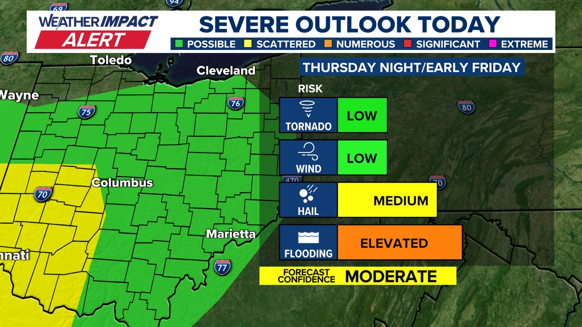
Marginal Severe‑Weather Risk Includes Tornado Potential The atmospheric setup—a low‑pressure system, warm front, and moderate wind shear—produced a level‑1 of 5 severe‑weather risk for central Ohio [2][3]. Early threats centered on wind and hail, but the risk shifted to heavy rain and flash flooding overnight [2][3]. Despite the marginal rating, the environment could support an isolated tornado, especially farther west [2][3].
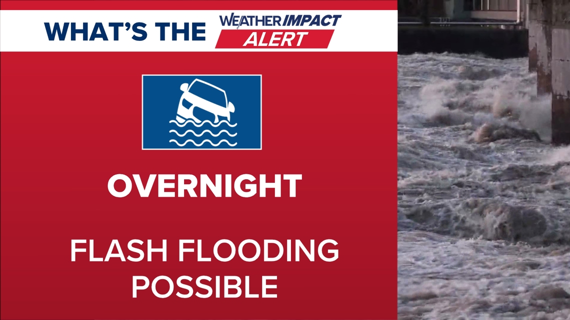
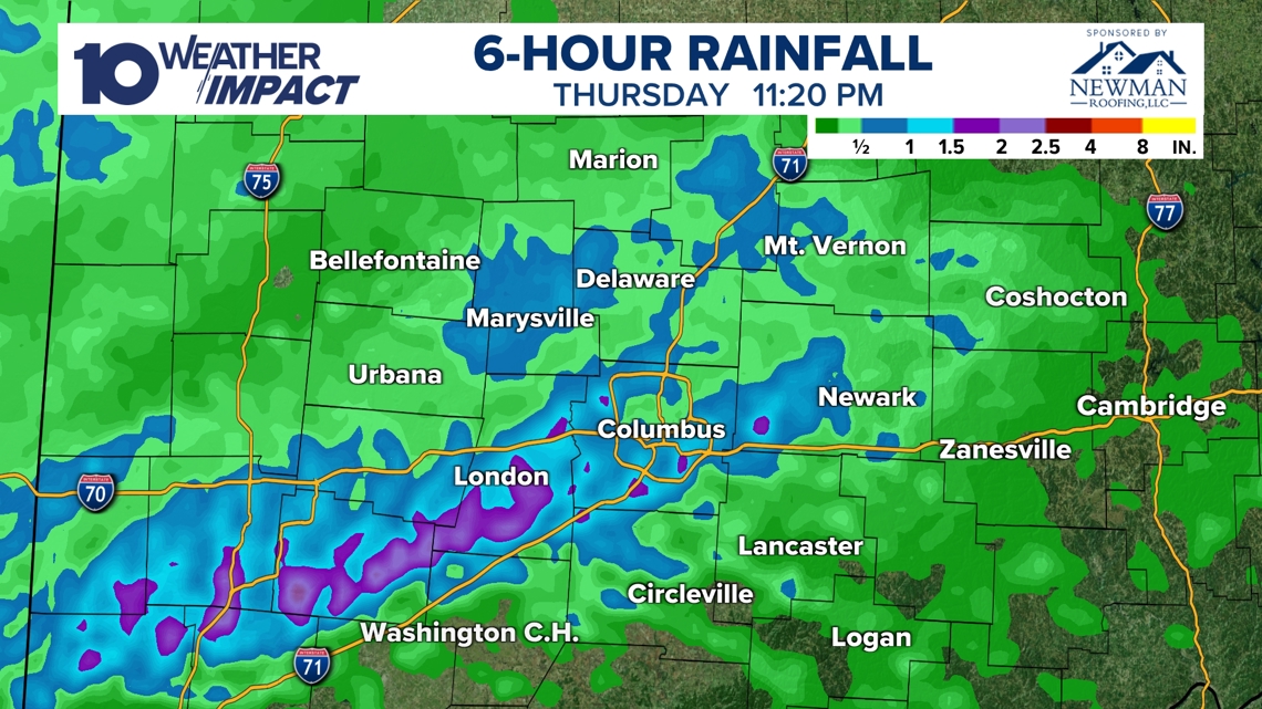
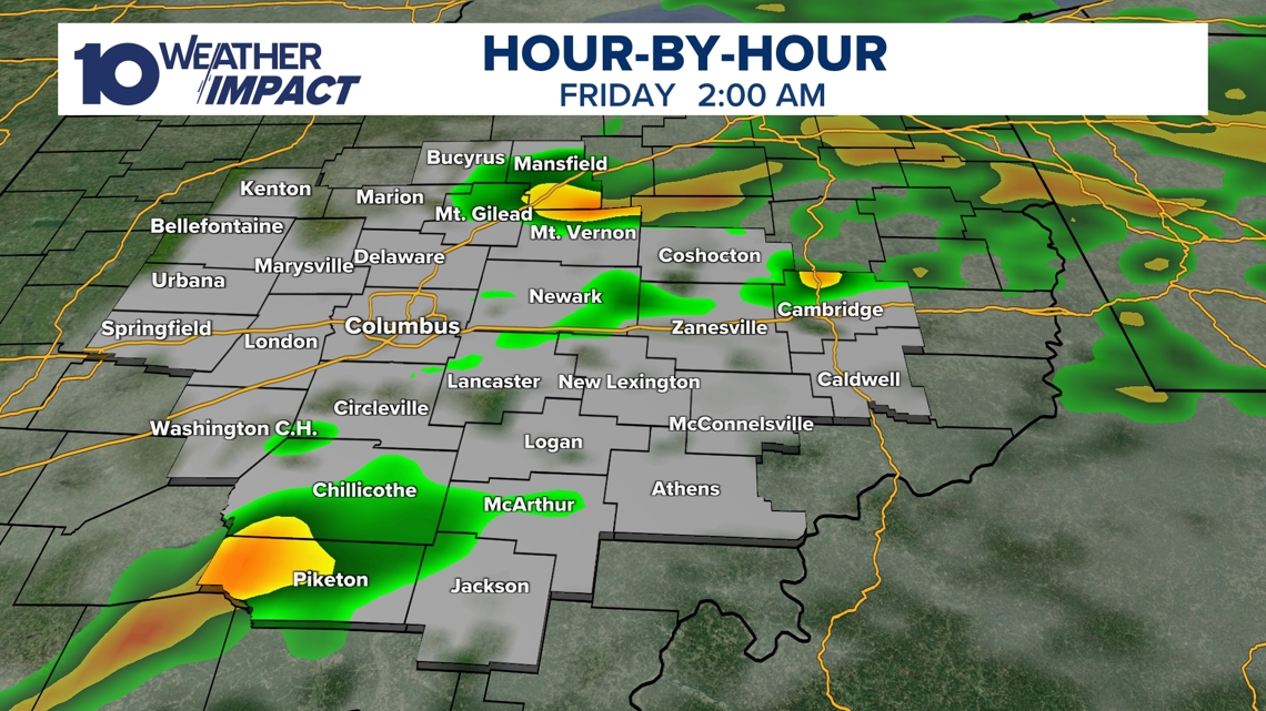
Rainfall Exceeds Two Inches, Flash Floods Expected Radar estimates showed rainfall totals surpassing two inches in several locations by 11:20 p.m. Thursday [2][3]. Fayette and Madison counties faced flash‑flood warnings through 2 a.m., prompting travel cautions on flooded roadways [2][3]. The heavy rain is expected to continue into early Friday before storms wane at sunrise [2][3].
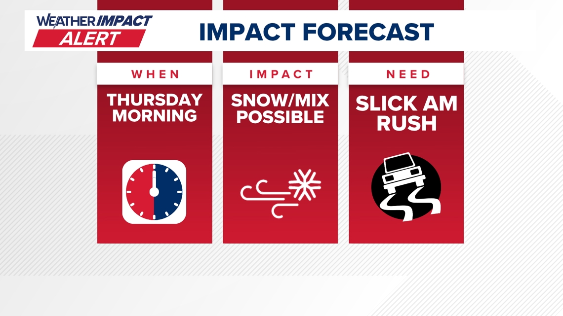
Wintry Mix May Add Ice and Snow Thursday Forecasters now anticipate a wintry mix of rain, snow, and ice across central Ohio Thursday, raising concerns about slippery roads and hazardous travel [1]. The 10 Weather Impact team highlighted uncertain accumulation amounts and divergent model predictions for rain versus snow distribution [1]. Residents are urged to monitor real‑time alerts and prepare for rapidly changing conditions [1][4].
Sources
-
1.
WBNS (Columbus, OH): Storm System Expected to Bring Rain, Snow and Ice to Central Ohio Thursday: Announces a 10 Weather Impact Alert, notes uncertain precipitation amounts, model divergence on rain versus snow, and warns of hazardous travel on Thursday‑Friday .
-
2.
WBNS (Columbus, OH): Strong Storm System Brings Severe Weather and Flood Risk to Central Ohio: Details the storm’s arrival Thursday night, marginal level‑1 severe‑weather risk, isolated tornado possibility, rainfall exceeding two inches, and flash‑flood threats in Fayette and Madison counties .
-
3.
WBNS (Columbus, OH): Strong Storm System Moves Through Central Ohio Thursday Night: Emphasizes warm, moist air driving intense thunderstorms around 9 p.m., county alerts shifting from wind/hail to flooding, and atmospheric conditions creating the marginal severe‑weather risk .
-
4.
WBNS (Columbus, OH): Dense Fog Advisory Triggers Weather Impact Alert for Central Ohio Tuesday: Reports a dense fog advisory reducing visibility, explains fog formation from cold, moist soil and warm air, and outlines the upcoming warm storm, near‑record heat, and potential snow showers later in the week .
Related Tickers
Timeline
Dec 5, 2025 – Ohio records unprecedented low wind chills as temperatures dip into the single digits and teens while wind speeds amplify the cold, prompting forecasts of a gradual warm‑up into the 20s‑30s by afternoon and a wintry front expected Sunday [14].
Dec 9, 2025 – A 10TV Weather Impact Alert Day warns that a strong Midwest storm brings a rain‑snow mix this morning, gusty winds up to 40 mph, and minimal snow accumulations, while a weaker system is forecast to arrive Friday into Saturday [13].
Dec 12, 2025 – Snowfall up to 9 inches blankets central Ohio on Saturday, triggering snow emergencies, blowing snow with 25 mph gusts, and wind chills near or below zero on Sunday and Monday [12].
Dec 13, 2025 – Sub‑zero wind chills persist Sunday and Monday as lingering cold air follows the heavy Saturday snow, with wind chills reaching –5 °F to –10 °F and schools and churches reporting closures [12].
Dec 27, 2025 – A developing storm system moves into central Ohio late Sunday night, bringing rain and thunderstorms with a Level 1 severe‑weather risk, damaging wind gusts near 60 mph, and a rapid 40‑degree temperature drop that could cause a flash‑freeze Monday morning [11].
Dec 30, 2025 – A strong low‑pressure system drives Monday’s wind gusts to 40‑50+ mph across central Ohio, prompting a Weather Impact Alert Day, wind‑advisories, and warnings of power outages as temperatures plunge into the low 20s by early Tuesday [10].
Dec 31, 2025 – Snow begins after 4 p.m., delivering 1‑3 inches of accumulation through the evening, creating breezy wind chills in the teens and disrupting travel for OSU game fans and New Year’s Eve celebrations [9].
Jan 1, 2026 – A Weather Impact Alert Day warns that up to 2 inches of snow may fall early tonight, with breezy winds and teen‑degree wind chills creating slippery roads for OSU game‑goers and New Year’s Eve plans [8].
Jan 11, 2026 – A band of snow showers moves in overnight into Sunday, producing dustings to a half‑inch as temperatures sit in the 20s‑30s, while strong winds drive wind chills into the 10s‑20s and sunshine returns with 40 °F highs on Monday and Tuesday [7].
Jan 21, 2026 – A winter‑storm watch covers six southern Ohio counties as an arctic blast drives single‑digit temperatures and subzero wind chills from Friday night through Monday, prompting multiple Weather Impact Alert Days and warnings of hazardous travel [6].
Feb 7, 2026 – Snow returns Friday with 1‑3 inches across central Ohio, followed by bitter cold and sub‑zero wind chills Saturday; a brief warm‑up on Sunday and another 1‑2‑inch snow band later Sunday set the stage for gradual warming into the 30s‑40s early next week [5].
Feb 17, 2026 – Dense fog returns Tuesday, reducing visibility to a quarter‑mile, leading to a Weather Impact Alert Day; forecasters cite saturated soil and warm air influx as the cause and note an upcoming windy storm that could bring near‑record 66 °F heat, scattered rain, and a cooling front Friday [4].
Feb 20, 2026 – A strong storm system moves into central Ohio Thursday night, delivering warm, moist air‑driven thunderstorms around 9 p.m., shifting the primary risk from wind/hail to heavy rain and flash‑flooding with over 2 inches recorded by 11:20 p.m., while gusty winds linger Friday and snow showers may appear by Sunday [2][3].
Feb 23, 2026 – The 10 Weather Impact team issues an alert for Thursday’s storm, warning of rain, snow and ice across central Ohio from Wednesday night into Thursday daytime, with uncertain accumulation amounts, slippery roads, and chief meteorologist Chris Tomer urging drivers to stay alert and monitor updates [1].
Dive deeper (10 sub-stories)
-
Ohio Braces for Mixed Rain, Snow and Ice Thursday Night Into Day
(2 articles)
-
Central Ohio Faces Heavy Rain and Flash Flood Threat Thursday Night
(2 articles)
-
WBNS (Columbus, OH): Dense Fog Advisory Triggers Weather Impact Alert for Central Ohio Tuesday
-
Snow Returns to Central Ohio Friday, Cold Lingers as Forecast Predicts Gradual Warm‑Up
(2 articles)
-
WBNS (Columbus, OH): Central Ohio braces for weekend snow and subzero wind chills as arctic blast returns
-
WBNS (Columbus, OH): Snow showers expected in central Ohio overnight into Sunday as cold air moves in
-
Central Ohio Braces for Up to Two Inches of Snow as Weather Impact Alert Day Begins
(2 articles)
-
WBNS (Columbus, OH): Central Ohio braces for 40-50 mph wind gusts Monday as a strong low pressure system moves through
-
WBNS (Columbus, OH): Storm system may bring thunderstorms to central Ohio overnight
-
WBNS (Columbus, OH): Ohio Experiences Record Low Wind Chills on Friday Morning
All related articles (14 articles)
-
WBNS (Columbus, OH): Storm System Expected to Bring Rain, Snow and Ice to Central Ohio Thursday
-
WBNS (Columbus, OH): Strong Storm System Brings Severe Weather and Flood Risk to Central Ohio
-
WBNS (Columbus, OH): Strong Storm System Moves Through Central Ohio Thursday Night
-
WBNS (Columbus, OH): Dense Fog Advisory Triggers Weather Impact Alert for Central Ohio Tuesday
-
WBNS (Columbus, OH): Snow Returns to Central Ohio as Bitter Cold Lingers, Forecast Calls for Gradual Warm‑up
-
WBNS (Columbus, OH): Central Ohio braces for weekend snow and subzero wind chills as arctic blast returns
-
WBNS (Columbus, OH): Snow showers expected in central Ohio overnight into Sunday as cold air moves in
-
WBNS (Columbus, OH): Central Ohio braces for up to 2 inches of snow as Weather Impact Alert Day is issued
-
WBNS (Columbus, OH): Snow expected this evening across central and southern Ohio with 1-3 inches of accumulation
-
WBNS (Columbus, OH): Central Ohio braces for 40-50 mph wind gusts Monday as a strong low pressure system moves through
-
WBNS (Columbus, OH): Storm system may bring thunderstorms to central Ohio overnight
-
WBNS (Columbus, OH): Sub-zero wind chills Sunday & Monday after heavy snow Saturday
-
WBNS (Columbus, OH): Rain, snow and wind impacting Wednesday morning commute in central Ohio
-
WBNS (Columbus, OH): Ohio Experiences Record Low Wind Chills on Friday Morning
External resources (8 links)
- https://www.facebook.com/ChrisTomer (cited 3 times)
- https://www.facebook.com/GarofaloWX (cited 3 times)
- https://www.facebook.com/mikebehrenswx (cited 3 times)
- https://www.facebook.com/AaronWhiteTV (cited 2 times)
- http://facebook.com/AaronWhiteTV/ (cited 1 times)
- http://instagram.com/aaronwhitetv/ (cited 1 times)
- http://x.com/AaronWhiteTV (cited 1 times)
- https://www.facebook.com/AaronWhiteTV/ (cited 1 times)