Central Ohio Braces for Light Snow Friday as Temperatures Stay in Low 20s
Updated (14 articles)

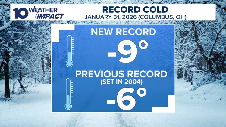
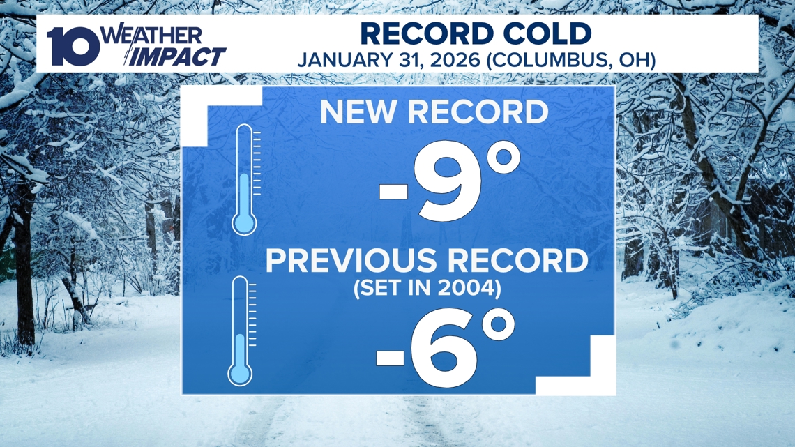
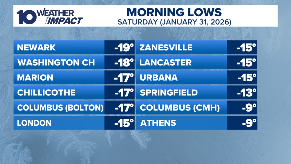
Record‑Breaking Cold Hits Columbus and Surrounding Areas On Saturday morning Columbus recorded a historic –9°F, shattering the previous –6°F record, while nearby stations reported temperatures from –10°F to –19°F and wind chills plunging to –30°F [4][2]. The extreme reading triggered a 10 Weather Impact Alert Day, warning of hazardous conditions [2]. Meteorologist Aaron White highlighted the widespread bitter cold across central and southern Ohio [4].
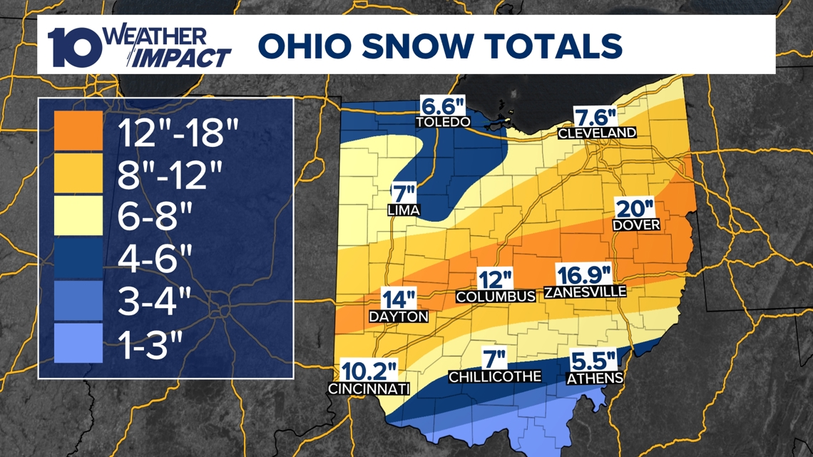
Deep Snowpack Reinforces Arctic Air Across Central Ohio Snow depths of 8‑16+ inches blanket the state, with central Ohio reporting the same range and the snow cover persisting throughout the weekend [2][3][4]. The deep snowpack traps cold air, slowing any warming trend and extending the deep freeze [2]. Detailed accumulation data are available on the station’s snow‑report page [2].
Arctic Canadian Air Mass Keeps Temperatures Below 20°F A surge of frigid air moving south from Canada will hold daytime highs below the 20s for the remainder of the weekend, preventing any significant warm‑up until the following week [2][3][4]. Forecast models show temperatures remaining in the low‑20 °F range on Wednesday and Thursday [1]. Meteorologists expect a gradual rise into the 20s and near 30°F early next week [4].
Upcoming Light Snow Friday Followed by Subzero Wind Chills A new system on Friday is expected to bring light snow across central Ohio, with accumulations limited to a dusting or at most two inches [1]. Wednesday and Thursday will see daytime highs in the low‑20 °F range, while Saturday and Sunday mornings are forecast to experience subzero wind chills [1]. Computer models suggest temperatures could climb into the 40 °F range by the end of the next week [1].
10 Weather Impact Alert Extended Through Sunday, Residents Urged to Prepare The 10 Weather Impact Alert Day was prolonged through Sunday morning due to continued low single‑digit temperatures and dangerous wind chills [2][3]. The alert advises residents to take precautions against frostbite and hypothermia. Updates and live streams are available free via the 10TV+ app on Roku and Amazon Fire TV [2][3].
Sources
-
1.
WBNS:Snow Returns to Central Ohio This Week: Details the short‑lived Monday flurries, Tuesday’s 1‑2‑inch snowfall, Wednesday‑Thursday low‑20 °F highs, Friday’s light snow up to two inches, weekend subzero wind chills, and a warm‑up to the 40s next week .
-
2.
WBNS:Columbus Endures Record Cold as Snowpack Persists, Warmer Weather Expected Next Week: Reports the –9°F record low, 8‑16+ inch snowpack, extended 10 Weather Impact Alert, and forecasts a gradual warm‑up beginning next week .
-
3.
WBNS:Columbus Record Low and Snowpack Keep Central Ohio in Deep Freeze: Emphasizes the –9°F record, prolonged alert, statewide snow cover, and ongoing Arctic air, while noting continuous monitoring via 10 Weather Impact .
-
4.
WBNS:Columbus Sets New Record Low Temperature of –9°F: Highlights the record low at John Glenn Airport, temperatures in the –10s to –19°F across the region, wind chills of –30°F, and a forecasted gradual warm‑up next week .
Timeline
Dec 2, 2025 – Central Ohio receives 3‑5 inches of snow, with Worthington topping 6 inches, prompting road slickness and school cancellations; Winter Weather Advisories lift as the system departs, but forecasters note another system tracking toward the Ohio Valley while temperatures stay at or below freezing [14].
Dec 5, 2025 – Ohio experiences record‑low wind chills as temperatures linger in the single digits and teens, wind‑chill values plunge below the air temperature, and forecasts call for a gradual warm‑up into the 20s‑30s by afternoon, offering brief relief before the weekend [13].
Dec 9, 2025 – A 10 TV Weather Impact Alert Day warns of a rain‑snow mix affecting Wednesday morning commutes, with gusts up to 40 mph and minimal snow accumulation due to near‑freezing temperatures; a weaker system is expected Friday into Saturday [12].
Dec 11, 2025 – Snow totals reach up to 9 inches from Saturday’s heavy snowfall; wind gusts of 25 mph produce blowing snow, wind chills hover near or below zero on Sunday‑Monday, snow emergencies are declared in several counties, and Cold Weather Advisories remain in effect [11].
Dec 27, 2025 – A strong low‑pressure system moves into the Great Lakes, setting the stage for Monday’s 40‑50 mph wind gusts across Ohio, prompting a Weather Impact Alert Day focused on potential power outages and travel disruptions [9].
Dec 28‑29, 2025 – The same system brings rain and thunderstorms Sunday night into Monday, with a Level 1 severe‑weather risk and a rapid 40‑degree temperature drop from the 60s to the 20s, creating flash‑freeze hazards; gusts of 60 mph threaten damage despite limited tornado risk [10].
Dec 31, 2025 – Snow begins after 4 p.m. across central and southern Ohio, delivering 1‑3 inches by night’s end; the Weather Impact Alert targets OSU game travel and New Year’s Eve plans, while high temperatures stay in the 20s and wind chills remain in the teens [8].
Jan 1, 2026 – Central Ohio braces for up to 2 inches of snow as a Weather Impact Alert Day warns of travel risks for New Year’s Eve and an OSU game; most areas see 0.5‑1.5 inches, temperatures linger in the 20s, and the system wraps up late tonight [7].
Jan 11, 2026 – A northwest airflow ushers in colder air, dropping temperatures into the 20s overnight; light snow showers bring dustings to a half‑inch, wind chills dive into the 10s‑20s, and sunshine returns Monday‑Tuesday with highs rebounding into the 40s [6].
Jan 20‑21, 2026 – An arctic blast returns, prompting a Winter Storm Watch for six southern counties and extending 10 Weather Impact Alert Days through the weekend; single‑digit temperatures and subzero wind chills dominate Friday night into Saturday, while snow chances remain uncertain but possible, especially Saturday evening into Sunday [5].
Jan 31, 2026 – Columbus records a new all‑time low of –9 °F at John Glenn Airport, shattering the 2004 record of –6 °F; nearby locations report –10 °F to –19 °F with wind chills near –30 °F, and meteorologists forecast a gradual warm‑up into the 20s‑30s next week [4].
Feb 1, 2026 – The record low of –9 °F persists across central Ohio, extending the 10 Weather Impact Alert Day through Sunday as snowpack of 8‑16+ inches blankets the state, while frigid Canadian arctic air keeps temperatures below the 20s until the following week [3].
Feb 1‑2, 2026 – Columbus endures record cold with a deep snowpack of 8‑16+ inches, a 10 Weather Impact Alert Day running through Sunday, and Canadian arctic air preventing temperatures from rising above 20 °F until next week; statewide snow cover locks in the deep freeze [2].
Feb 2‑4, 2026 – Snow returns to central Ohio: Monday brings brief flurries, Tuesday deposits 1‑2 inches that partly melt, Wednesday and Thursday see daytime highs in the low‑20 °F range, Friday offers a wider but light snow event up to two inches, weekend subzero wind chills follow, and models predict a warm‑up into the 40s by the end of the next week [1].
Dive deeper (11 sub-stories)
-
Snow Returns to Central Ohio with Three Systems and Winter Advisory
(2 articles)
-
Columbus Hits Record –9°F, Snowpack Over 16 Inches, Cold to Last Until Next Week
(2 articles)
-
WBNS (Columbus, OH): Columbus Sets New Record Low Temperature of –9°F
-
WBNS (Columbus, OH): Central Ohio braces for weekend snow and subzero wind chills as arctic blast returns
-
WBNS (Columbus, OH): Snow showers expected in central Ohio overnight into Sunday as cold air moves in
-
Central Ohio Braces for Up to Two Inches of Snow as Weather Impact Alert Day Begins
(2 articles)
-
WBNS (Columbus, OH): Central Ohio braces for 40-50 mph wind gusts Monday as a strong low pressure system moves through
-
WBNS (Columbus, OH): Storm system may bring thunderstorms to central Ohio overnight
-
WBNS (Columbus, OH): Sub-zero wind chills Sunday & Monday after heavy snow Saturday
-
WBNS (Columbus, OH): Rain, snow and wind impacting Wednesday morning commute in central Ohio
-
WBNS (Columbus, OH): Ohio Experiences Record Low Wind Chills on Friday Morning
All related articles (14 articles)
-
WBNS (Columbus, OH): Snow Returns to Central Ohio This Week
-
WBNS (Columbus, OH): Columbus Endures Record Cold as Snowpack Persists, Warmer Weather Expected Next Week
-
WBNS (Columbus, OH): Columbus Record Low and Snowpack Keep Central Ohio in Deep Freeze
-
WBNS (Columbus, OH): Columbus Sets New Record Low Temperature of –9°F
-
WBNS (Columbus, OH): Central Ohio braces for weekend snow and subzero wind chills as arctic blast returns
-
WBNS (Columbus, OH): Snow showers expected in central Ohio overnight into Sunday as cold air moves in
-
WBNS (Columbus, OH): Central Ohio braces for up to 2 inches of snow as Weather Impact Alert Day is issued
-
WBNS (Columbus, OH): Snow expected this evening across central and southern Ohio with 1-3 inches of accumulation
-
WBNS (Columbus, OH): Central Ohio braces for 40-50 mph wind gusts Monday as a strong low pressure system moves through
-
WBNS (Columbus, OH): Storm system may bring thunderstorms to central Ohio overnight
-
WBNS (Columbus, OH): Sub-zero wind chills Sunday & Monday after heavy snow Saturday
-
WBNS (Columbus, OH): Rain, snow and wind impacting Wednesday morning commute in central Ohio
-
WBNS (Columbus, OH): Ohio Experiences Record Low Wind Chills on Friday Morning
-
WBNS (Columbus, OH): Central Ohio Receives Up to 5 inches of Snow Tuesday Morning
External resources (3 links)
- http://facebook.com/AaronWhiteTV/ (cited 2 times)
- http://instagram.com/aaronwhitetv/ (cited 2 times)
- http://x.com/AaronWhiteTV (cited 2 times)