Western Washington Braces for Week‑Long Storms, Snow, and 45 mph Winds Starting Feb 22
Updated (24 articles)

Multi‑system low‑pressure surge drives rain, snow, and gusty winds A powerful low‑pressure system off British Columbia is delivering rain and mountain snow across western Washington, with a series of storm systems expected to batter the region from this weekend into next week [1][2]. The National Weather Service has issued a Wind Advisory for the San Juan Islands through 2 p.m. on Sunday, with southeasterly winds of 15‑25 mph and gusts up to 45 mph [1][2][3]. A Winter Weather Advisory covers the Cascades, including Snoqualmie Pass, from Sunday night to Monday afternoon, forecasting snow levels near 3,000‑3,500 ft and 5‑12 inches of snow [1][2]. Forecast models show the storm lingering, bringing additional rain and snow as highs climb to the low 50s °F [1][2].
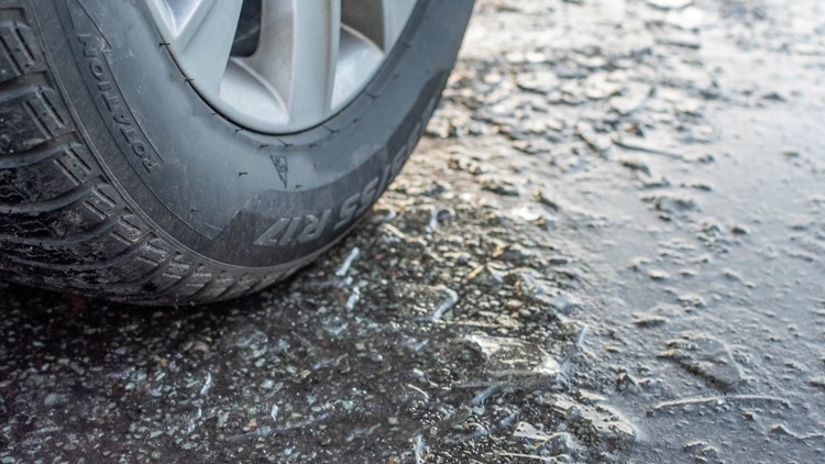
Snow levels rapidly descend, threatening lowland areas Snow levels are projected to fall to 2,500 ft by Wednesday and to 1,000‑1,500 ft by the weekend, allowing occasional low‑elevation snow in Snohomish, King, and Pierce counties [1][2][6]. Earlier this week, spotty lowland snow already fell at elevations as low as 300‑400 ft in Bothell and Maltby, prompting school delays and cancellations in Granite Falls [4]. Light rain and gray skies will persist through Sunday, while mountain snow accumulates and snow levels continue dropping Sunday night into Monday morning, potentially impeding pass travel [3]. The combination of low snow levels and lingering moisture raises concerns for hazardous road conditions, especially where rain‑snow mixes may refreeze on brief breaks [6].
Travel and safety impacts intensify with wind and snow The wind advisory extends into Sunday morning for the Snohomish, King, and Pierce foothills, with gusts of 30‑40 mph expected and stronger winds along the coast and Strait of Juan de Fuca [3]. Snow accumulation and falling snow levels could make mountain passes difficult or impassable, prompting drivers to monitor updates [1][3]. Earlier lowland snow produced mainly slush rather than deep accumulation, but roads remained slick, and schools adjusted schedules in response [4]. Residents are urged to prepare for possible travel disruptions and to heed local advisories throughout the storm period [1][2][3].
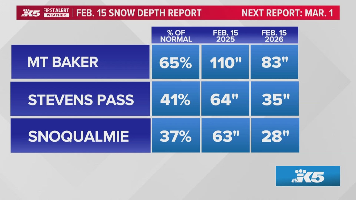
Snowpack remains well below normal, raising water‑resource worries As of mid‑February, the Cascades hold roughly 65 % of average snowpack, with elevations between 3,000‑5,000 ft at only 40 % of typical depth, threatening summer water storage [5]. Although models forecast additional snowfall later in the week, prevailing winds parallel the Cascades, limiting precipitation capture and delaying snowpack recovery [5]. The deficit mirrors past El Niño‑linked winters, and a weak La Niña currently persists, influencing the season’s precipitation pattern [5]. Continued low snowpack could affect fire risk, ski tourism, and downstream water supplies if the trend does not reverse [5].
Sources
-
1.
King5: Western Washington Braces for Week‑Long Storms with Snow, Rain, and Strong Winds – Details the multi‑day storm sequence, wind advisory for San Juan Islands, and projected snow levels through the week .
-
2.
King5: Western Washington Braces for Storm, Wind and Snow Advisories – Highlights the BC‑origin storm, wind and winter weather advisories, and seven‑day forecast showing rain, snow, and warming highs .
-
3.
King5: Wind Advisory Extends Through Sunday Morning with Gusts Up to 45 mph – Focuses on the extended wind advisory for foothill valleys, breezy conditions from a Pacific low, and ongoing rain and mountain snow .
-
4.
King5: Spotty Lowland Snow Hits Snohomish, King, and Pierce Counties – Reports low‑elevation snow bursts on Feb 19, school delays in Granite Falls, and minimal accumulation on roads .
-
5.
King5: Washington Snowpack Lags Normal, Raising Summer Water Concerns – Provides statewide snowpack percentages, deficits at Snoqualmie Pass, and implications for water resources and ski tourism .
-
6.
King5: Lowland Snow Possible Wednesday as Western Washington Precipitation Increases – Forecasts snow levels dropping to ~500 ft on Wednesday, mixed rain‑snow impacts, and potential slick roads .
Related Tickers
Timeline
Dec 19, 2025 – Warm weather leaves the West with well‑below‑average snowpack, forcing Lake Tahoe lifts to run at limited capacity and prompting Utah’s Midway Ice Castles to be postponed indefinitely; Oregon’s Deschutes Basin records its slowest snow start since 1981, and officials warn that the thin snow threatens regional water supplies and wildfire risk [4][22].
Dec 20, 2025 – Heavy mountain snow falls across the Cascades ahead of Christmas, with Stevens Pass topping 18 inches and Snoqualmie Pass about 10 inches, while snow levels sit 2,000‑3,000 ft and travel on passes is expected to worsen through the weekend [21].
Dec 27, 2025 – Light snow drifts into low‑elevation Puget Sound areas, delivering up to 2 inches in Snohomish and King counties, but a Winter Weather Advisory warns that snow levels could drop to 2,500 ft and 6‑12 inches may fall on Cascade passes, making post‑Christmas travel “very difficult to impossible” [19][20].
Dec 31, 2025 – Jan 1, 2026 – A high‑pressure ridge keeps western Washington dry on New Year’s Eve, a rare break from the typical rain, while forecasters expect the ridge to weaken Thursday, bringing showers and a rain‑snow mix to lowlands early in the new year [18].
Jan 6, 2026 – The National Weather Service issues winter‑storm warnings for Washington, Oregon, Alaska, Idaho and Montana, forecasting up to 35 inches of snow and 45 mph gusts in the Cascades and urging motorists to delay travel and carry emergency supplies [2]; simultaneously a Winter Storm Warning targets the Cascades, projecting 2‑4 feet of snow and wind gusts up to 35 mph, with avalanche danger rising to “considerable” [17].
Jan 8, 2026 – A colder system drives snow levels down to about 500 ft overnight, creating the potential for spotty low‑land snow or rain‑snow mixes in western Washington, though accumulation remains minimal and the main impact is slick roads in the lowlands [16].
Jan 9, 2026 – A persistent ridge produces a western‑U.S. snow drought, slashing snowpack to record lows; Utah backcountry snowmobiling owner Brad Riesenberg says customers “cancel tours” and calls the season “among the worst winters,” while climatologist Erinanne Saffell notes Phoenix and Tucson record their hottest December, raising concerns for the 2034 Salt Lake City Winter Olympics [1].
Jan 15, 2026 – A ridge of high pressure extends the dry spell across western Washington, delivering record‑tying January warmth (Sea‑Tac 58°F) and keeping snow levels near 12,000 ft, with the next meaningful rain not expected until late next week [15].
Jan 24, 2026 – A Cold Weather Advisory blankets the Seattle metro, dropping temperatures to the low‑20s °F and warning of hypothermia risk, while the region remains dry and sunny through the weekend [14].
Jan 27, 2026 – Seattle’s 14‑day rainless streak sits one day shy of the 1963 record; meteorologists forecast light rain Tuesday night that will end the dry spell, but the warm southwest moisture threatens to melt the already‑thin snowpack, with snow levels expected to fall to ~4,000 ft on Wednesday [13].
Jan 29, 2026 – Despite recent snowfall, Cascade snowpack stays far below normal; Stevens Pass adds only 2‑3 inches, Snoqualmie Pass 1‑2 inches, and Oregon’s statewide snowpack ranks second‑lowest since 1981, leaving central and southern Cascades with deep deficits that jeopardize spring streamflow [12].
Feb 4, 2026 – Skiers at Snoqualmie Pass describe “spring‑like” conditions with slushy surfaces and exposed rock, noting that regional snowpack sits under 50 % of normal; Climate Central meteorologist Shel Winkley says NASA imagery labels the January snowpack “a thin winter coat,” while snowboarder Jeremy Sampson points out empty lifts but heightened avalanche risk [11].
Feb 17, 2026 – Forecasts call for low‑elevation snow on Wednesday as snow levels hover 500‑1,000 ft, with a rain‑snow mix possible from the Kitsap Peninsula to coastal foothills; meteorologist Rich Marriott warns of slick roads during precipitation breaks, though anchor Parella Lewis expects limited overall impact [10].
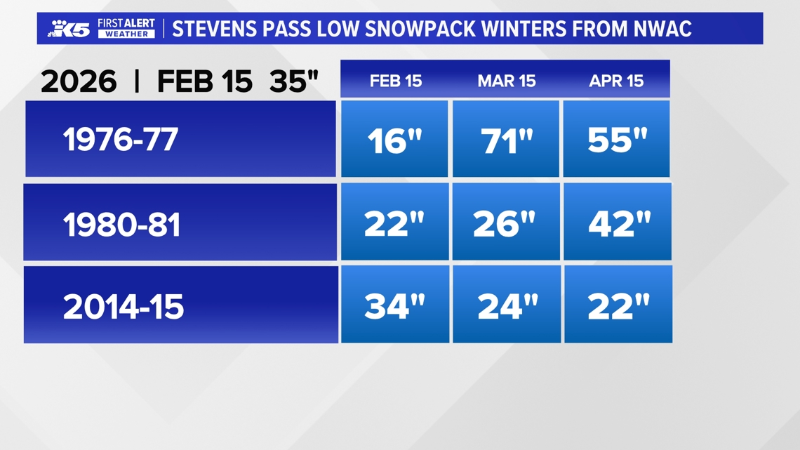
Feb 18, 2026 – Washington’s snowpack averages roughly 65 % of normal, with 3,000‑5,000 ft elevations at only 40 % of typical depth, echoing dry winters of 1976‑77, 1980‑81 and 2014‑15; a weak La Niña shifts toward neutral, giving a 50‑60 % chance of a weak El Niño next winter, which could alter future snowpack trends [9].
Feb 19, 2026 – Spotty low‑land snow hits Snohomish, King and Pierce counties, prompting a two‑hour school delay in Granite Falls and a cancellation in neighboring districts, while snow levels remain between 500‑1,000 ft and accumulation stays minimal [8].
Feb 22, 2026 – A series of storm systems batter western Washington with rain, mountain snow and gusty winds; a Wind Advisory for Snohomish, King and Pierce foothills warns of 45 mph gusts, a Winter Weather Advisory places the Cascades under snow from 3,000‑3,500 ft with 5‑12 inches expected, and snow levels are projected to fall to 2,500 ft by Wednesday, setting up continued hazardous travel through the week [5][6][7].
Dive deeper (6 sub-stories)
-
Western Washington Braces for Week‑Long Storms, Snow, and Wind Advisories Starting Saturday
(12 articles)
-
Lowland Snow Bursts Across Western Washington Prompt School Delays and Light Slush on Feb 19
(3 articles)
-
King5 (Seattle, WA): Spring‑like Ski Conditions Hit Snoqualmie Pass as Snowpack Plummets
-
Seattle’s 14‑Day Dry Spell Set to End With Tuesday Night Showers
(4 articles)
-
King5 (Seattle, WA): Cold Weather Advisory Extends Into Saturday Morning for Seattle Metro
-
Western U.S. Snow Drought Deepens, Threatening Tourism, Water Supplies, 2034 Olympics
(3 articles)
All related articles (24 articles)
-
King5 (Seattle, WA): Western Washington Braces for Week‑Long Storms with Snow, Rain, and Strong Winds
-
King5 (Seattle, WA): Western Washington Braces for Storm, Wind and Snow Advisories
-
King5 (Seattle, WA): Wind Advisory Extends Through Sunday Morning with Gusts Up to 45 mph
-
King5 (Seattle, WA): Spotty Lowland Snow Hits Snohomish, King, and Pierce Counties
-
King5 (Seattle, WA): Washington Snowpack Lags Normal, Raising Summer Water Concerns
-
King5 (Seattle, WA): Lowland Snow Possible Wednesday as Western Washington Precipitation Increases
-
King5 (Seattle, WA): Spring‑like Ski Conditions Hit Snoqualmie Pass as Snowpack Plummets
-
King5 (Seattle, WA): Cascade Mountains Snowpack Lags Behind Recent Snowfall
-
King5 (Seattle, WA): Seattle’s 14‑Day Dry Spell Nears Record as Rain Returns Tuesday
-
King5 (Seattle, WA): Cold Weather Advisory Extends Into Saturday Morning for Seattle Metro
-
King5 (Seattle, WA): Extended dry weather persists across western Washington through weekend
-
CNN: The western US is in a snow drought, raising fears for summer water supplies
-
King5 (Seattle, WA): Snow levels fall overnight across western Washington, raising chance of lowland wet snow and slick roads
-
King5 (Seattle, WA): National Weather Service issues Winter Storm Warning as heavy snow and high winds head for the Cascades
-
Newsweek: NWS issues winter-storm warnings for five states as up to 35 inches of snow and high winds are forecast
-
King5 (Seattle, WA): Dry New Year’s Eve ends rain; showers expected on New Year’s Day in Western Washington
-
King5 (Seattle, WA): Western Washington sees light snow, then dry stretch with freezing nights ahead
-
King5 (Seattle, WA): Snow could complicate post-Christmas mountain pass travel in Washington
-
King5 (Seattle, WA): Heavy mountain snow continues toward Christmas across Cascades, with up to 2–3 feet possible at some passes
-
King5 (Seattle, WA): Warm weather and low snowpack disrupt Western ski resorts
-
AP: Warm weather and low snowpack slow Western ski resorts
-
Newsweek: Winter storm warnings issued for five states with up to three feet of snow through Saturday
-
King5 (Seattle, WA): Blustery weather eases in western Washington
-
King5 (Seattle, WA): Dry Weather Expected Over Holiday Weekend, With Spotty Showers Possible
External resources (20 links)
- https://forecast.weather.gov/wwamap/wwatxtget.php?cwa=usa&wwa=Winter%20Storm%20Warning (cited 6 times)
- https://forecast.weather.gov/wwamap/wwatxtget.php?cwa=SEW&wwa=wind%20advisory (cited 2 times)
- https://forecast.weather.gov/wwamap/wwatxtget.php?cwa=SEW&wwa=winter%20weather%20advisory (cited 2 times)
- https://nwcc-apps.sc.egov.usda.gov/imap/#version=2&elements=&networks=!&states=!&basins=!&hucs=&minElevation=&maxElevation=&elementSelectType=any&activeOnly=true&activeForecastPointsOnly=true&hucLabels=false&hucIdLabels=false&hucParameterLabels=true&stationLabels=&overlays=&hucOverlays=state&basinOpacity=100&basinNoDataOpacity=100&basemapOpacity=100&maskOpacity=0&mode=data&openSections=dataElement,parameter,date,basin,options,elements,location,networks,baseMaps,overlays,labels&controlsOpen=true&popup=&popupMulti=&popupBasin=&base=esriWgc&displayType=basin&basinType=6&dataElement=SNWD&depth=-8¶meter=PCTPORMED&frequency=MONTHLY&duration=I&customDuration=&dayPart=E&monthPart=E&forecastPubDay=1&forecastExceedance=50&useMixedPast=true&seqColor=2&divColor=7&scaleType=D&scaleMin=&scaleMax=&referencePeriodType=POR&referenceBegin=1991&referenceEnd=2020&minimumYears=20&hucAssociations=true&relativeDate=-1&lat=41.305&lon=-112.429&zoom=5.5 (cited 2 times)
- https://wsdot.com/travel/real-time/mountainpasses/Blewett (cited 2 times)
- https://wsdot.com/travel/real-time/mountainpasses/Cayuse (cited 2 times)
- https://wsdot.com/travel/real-time/mountainpasses/Chinook (cited 2 times)
- https://wsdot.com/travel/real-time/mountainpasses/Crystal-to-Greenwater (cited 2 times)
- https://wsdot.com/travel/real-time/mountainpasses/Mt.-Baker (cited 2 times)
- https://wsdot.com/travel/real-time/mountainpasses/North-Cascade-Hwy (cited 2 times)
- https://wsdot.com/travel/real-time/mountainpasses/Snoqualmie (cited 2 times)
- https://wsdot.com/travel/real-time/mountainpasses/Stevens (cited 2 times)
- https://wsdot.com/travel/real-time/mountainpasses/White (cited 2 times)
- https://forecast.weather.gov/showsigwx.php?warnzone=WAZ310&warncounty=WAC073&firewxzone=WAZ656&local_place1=4%2520Miles%2520NE%2520Bellingham%2520International%2520Airport%2520WA&product1=Wind+Advisory&lat=48.8243&lon=-122.4718 (cited 1 times)
- https://forecast.weather.gov/wwamap/wwatxtget.php?cwa=SEW&wwa=winter%2520storm%2520warning (cited 1 times)
- https://forecast.weather.gov/wwamap/wwatxtget.php?cwa=SEW&wwa=winter%2520weather%2520advisory (cited 1 times)
- https://nwcc-apps.sc.egov.usda.gov/imap/#version=169&elements=&networks=!MSNT&states=!&basins=!&hucs=&minElevation=&maxElevation=&elementSelectType=any&activeOnly=true&activeForecastPointsOnly=false&hucLabels=true&hucIdLabels=false&hucParameterLabels=true&stationLabels=&overlays=&hucOverlays=state&basinOpacity=75&basinNoDataOpacity=0&basemapOpacity=100&maskOpacity=100&mode=data&openSections=dataElement,parameter,date,basin,options,elements,location,networks,baseMaps,overlays,labels&controlsOpen=true&popup=&popupMulti=&popupBasin=&base=esriWsr&displayType=basin&basinType=wa_8&dataElement=WTEQ&depth=-8¶meter=PCTMED&frequency=DAILY&duration=I&customDuration=&dayPart=E&monthPart=B&forecastPubDay=1&forecastExceedance=50&useMixedPast=true&seqColor=1&divColor=7&scaleType=D&scaleMin=&scaleMax=&referencePeriodType=fixed&referenceBegin=1991&referenceEnd=2020&minimumYears=20&hucAssociations=true&relativeDate=-1&lat=48.124&lon=-120.914&zoom=6.9&autoExport=full,pdf,2,2,L,BL,Washington%2520SNOTEL,49.4893,44.9175,-114.8615,-125.2705 (cited 1 times)
- https://www.weather.gov/sew/ (cited 1 times)
- https://www.wsdot.com/traffic/passes/ (cited 1 times)
- https://nwac.us/avalanche-forecast/#/all/ (cited 1 times)