Snow Returns to Central Ohio with New Systems Tuesday‑Friday and Subzero Wind‑Chills
Updated (46 articles)

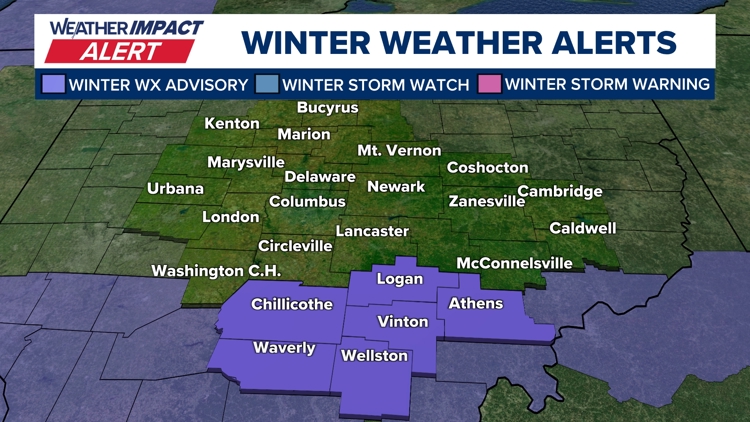

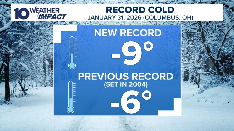

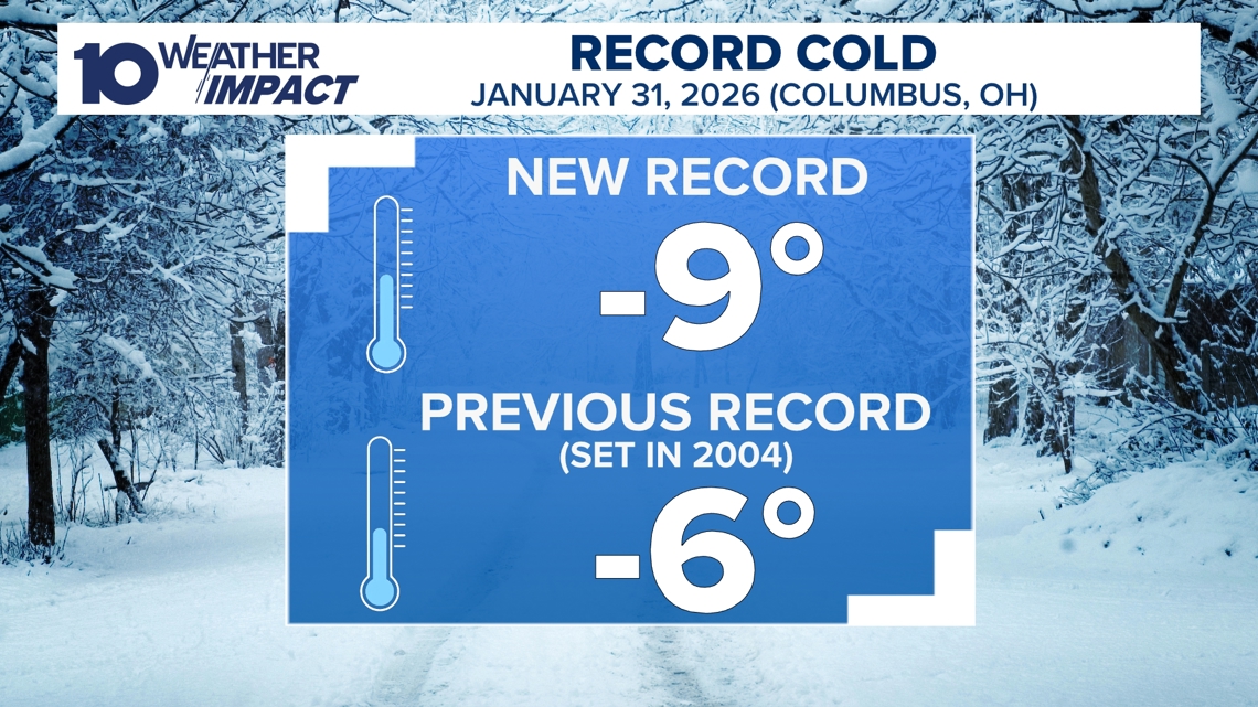
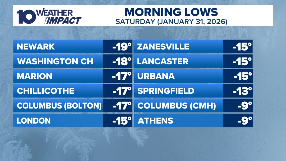
Columbus Hits Record Low Amid Arctic Air The city recorded a historic –9°F on Saturday, Jan. 31, shattering the prior –6°F record and prompting an extended 10 Weather Impact Alert Day through Sunday [4][2]. Wind‑chill values plunged to –30°F across central and southern Ohio, with temperatures remaining below 20°F as a frigid Canadian air mass settled over the region [2][1]. Meteorologists warned that the deep freeze would persist through the weekend, delaying any significant warming until the following week [3].
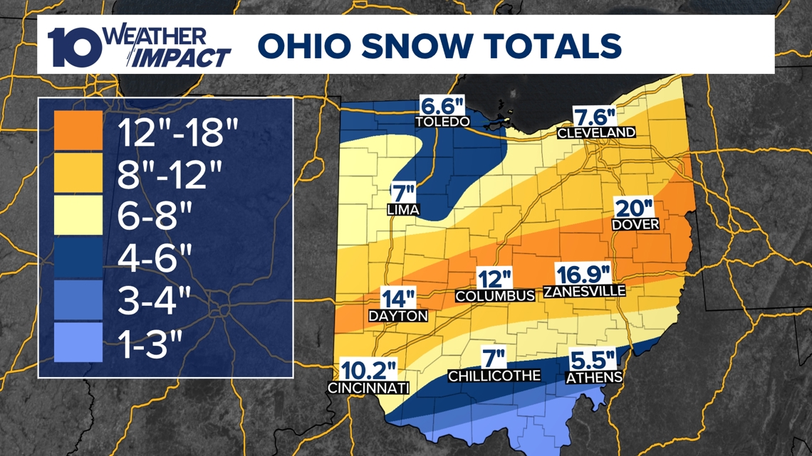
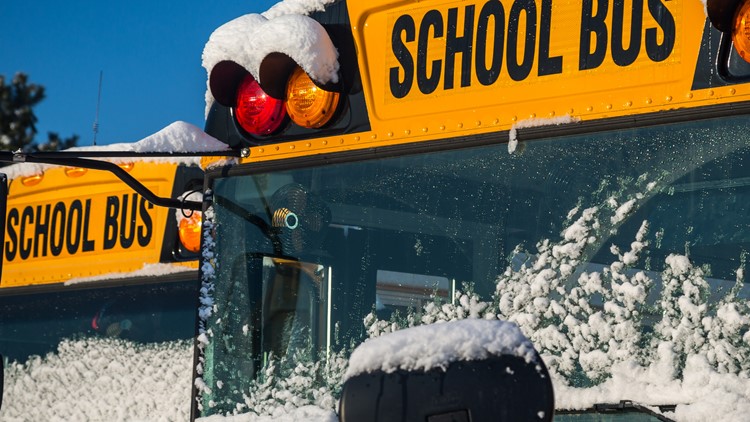
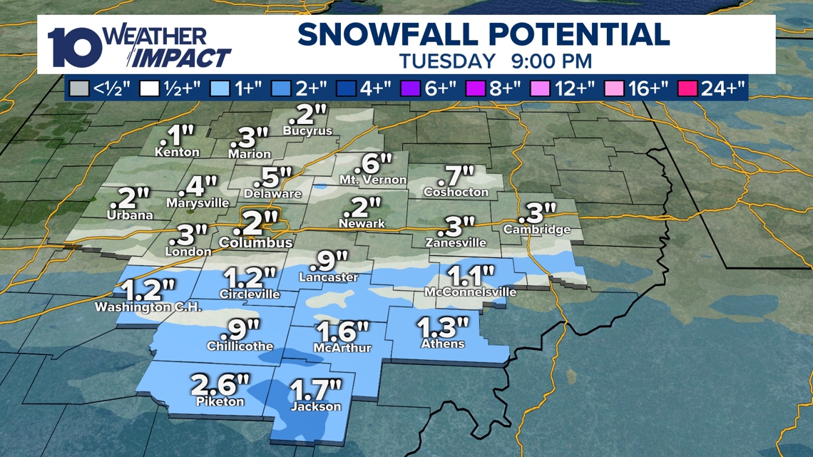
Snowpack Reaches 8‑16+ Inches, Triggering Emergencies Snowfall totals ranged from 8 to 16+ inches across central Ohio, with isolated reports of 20 inches in Dover and 17 inches near Zanesville [13][12]. The extensive snowpack forced Level 2 and Level 3 snow emergencies in most counties, restricting road travel to emergency vehicles in several areas [14][12]. These conditions reinforced the cold air, locking in sub‑zero temperatures and prompting widespread alerts from the 10 Weather Impact team [2][11].
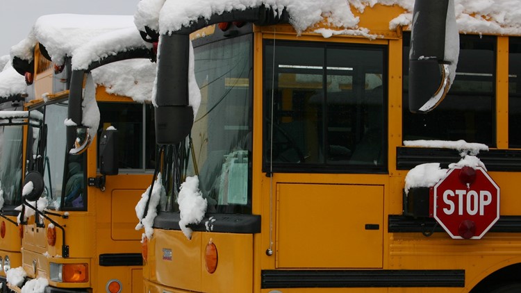
Schools and Zoo Shut Down Through Early February More than a dozen school districts, including Columbus City Schools, canceled classes for up to five consecutive days, with many planning to reopen on Monday after the snow emergencies lifted [5][7]. The Columbus Zoo and Aquarium remained closed through Feb. 1 to protect animals and visitors from the extreme cold and lingering snow [9]. Officials emphasized that the primary barrier to reopening was the hazardous cold rather than road access [5][8].
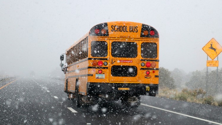
New Snow Systems Expected Tuesday Through Friday Forecasters announced a narrow band of light‑to‑moderate snow for Tuesday, delivering 1‑3 inches to areas south of I‑70, followed by a broader but lighter system on Friday that could produce dustings up to 2 inches [1]. After Tuesday’s snowfall clears, high temperatures are projected to dip into the 20s on Wednesday and Thursday before the Friday system arrives [1]. The weekend will bring subzero wind‑chill values as a much colder air mass moves in, setting the stage for a brief warming trend early next week [1].
Forecast Calls for Subzero Wind‑Chills Then Gradual Warmup Saturday and Sunday are expected to feature wind‑chills below 0°F, with daytime highs remaining in the low‑teens [1]. Computer models suggest a gradual rise to the 40°F range by the end of the following week, offering a short reprieve from the deep freeze [1]. Residents can track the evolving situation via the 10 Weather Impact alerts and the 10TV mobile app, which provide real‑time radar, warnings, and a 10‑day forecast [2][3].
Sources
-
1.
WBNS: Snow Returns to Central Ohio This Week: Details Tuesday‑Friday snow systems, 1‑3 inch Tuesday band, broader Friday dusting, mid‑week 20°F lows, subzero weekend wind chills, and a warming trend early next week .
-
2.
WBNS: Columbus Endures Record Cold as Snowpack Persists, Warmer Weather Expected Next Week: Reports –9°F record low, 8‑16+ inch snowpack, arctic air keeping temps below 20°F, and upcoming warming .
-
3.
WBNS: Columbus Record Low and Snowpack Keep Central Ohio in Deep Freeze: Mirrors record low, extended alerts, 8‑16+ inch snow, and sub‑20°F forecast .
-
4.
WBNS: Columbus Sets New Record Low Temperature of –9°F: Highlights –9°F at John Glenn Airport, –10°F to –19°F readings elsewhere, wind chills –30°F, and a gradual warmup next week .
-
5.
WBNS: Central Ohio Schools Set to Reopen After Snow‑Related Week‑Long Closures: Announces lifted snow emergencies, planned school reopenings Monday, and mayor’s statement on closures due to cold .
-
6.
WBNS: Central Ohio Schools Remain Closed as Winter Storm Extends to Fifth Day: Describes fifth day of school closures, impacts on Hilliard City Schools, and family coping strategies .
-
7.
WBNS: Columbus City Schools Cancel Classes Friday Amid Ongoing Winter Storm and Extreme Cold: Notes Friday cancellation, 8‑16 inch snowfall, Extreme Cold Warning through Wednesday, and week‑long sub‑20°F forecast .
-
8.
WBNS: Central Ohio Schools Shut Down Friday Amid Arctic Cold: Lists numerous district closures, subzero wind chills, potential record‑low tie on Saturday, and upcoming warming trend .
-
9.
WBNS: Columbus Zoo Remains Closed Through Feb. 1 Amid Record Snow and Subzero Cold: Explains zoo closure through Feb. 1, over 16 inches of snow, and ongoing subzero conditions .
-
10.
WBNS: Central Ohio School Districts Cancel Thursday Classes Amid Arctic Cold: Reports ten districts closing Thursday, wind chills –15°F to –20°F, and modest warming early next week .
-
11.
WBNS: Central Ohio School Districts Close Wednesday Amid Deep Freeze: Details Wednesday closures across many districts, 8‑16+ inch snow, and sub‑20°F temperatures through the week .
-
12.
WBNS: Ohio Winter Storm Leaves Over 16 Inches of Snow and Triggers Snow Emergencies: Highlights 16+ inch snowfall, Level 2/3 emergencies, and subzero temps with –10°F to –20°F wind chills .
-
13.
WBNS: Central Ohio Receives Up to 20 Inches of Snow as Major Winter Storm Ends: Notes 20‑inch maximum in Dover, snow emergencies, and subzero wind chills lasting a week .
-
14.
WBNS: Central Ohio Business and School Closures After Record Snowstorm: Covers Level 2 emergencies, zoo and court closures, college class cancellations, and the storm’s ranking as the fifth‑largest in Columbus history .
Timeline
Dec 2, 2025 – Central Ohio schools, courts, and several districts cancel or delay classes after an overnight snowstorm drops 2‑4 inches, prompting Snow Emergency levels 1‑3 and a 10 Weather Impact alert; Columbus City Schools, Franklin Local and others join the closures, and the county courts shut down for the day [29][30][27].
Dec 5, 2025 – Ohio records unprecedented low wind chills as temperatures linger in the single digits while strong winds drive wind‑chill values below any previous reading for the season [25].
Dec 11, 2025 – A cold northwest flow pushes temperatures into the 20s overnight, and a band of snow showers brings dustings to a half‑inch across central Ohio, with wind chills diving into the teens and twenties [17].
Dec 14, 2025 – After Saturday’s 9‑inch snowfall, wind gusts up to 25 mph produce blowing snow and wind chills near or below zero on Sunday and Monday, leading to snow emergencies in several counties [23].
Dec 15, 2025 – Columbus City Schools cancel Monday classes and extracurriculars because of lingering snow and subzero wind chills, while the district warns that temperatures will rebound into the 20s later in the week [22]; the same day, a broader list of central Ohio districts closes or delays due to slick roads and bitter cold [21].
Jan 1, 2026 – The 10 TV Weather Impact Team issues a Weather Impact Alert Day for early‑night snow, forecasting 0.5‑1.5 inches (up to 2 inches locally) and wind chills in the teens as residents travel to New Year’s events [18].
2004 – Columbus previously set its all‑time low of –6 °F on Jan. 31, a benchmark broken by the 2026 event [4].
Jan 16, 2026 – The Columbus Metropolitan Library opens its main branch as a cold‑weather shelter from noon to 9 p.m., offering Wi‑Fi and restrooms while all other branches close for Martin Luther King Jr. Day [16].
Jan 20, 2026 – Extreme cold drives wind chills to –15 °F, prompting dozens of districts—including Big Walnut, Coshocton City and Olentangy—to cancel or delay Tuesday classes; Columbus City Schools already observes a Professional Development Day, and a 10 TV Weather Impact Alert and NWS Cold Weather Advisory remain in effect [15].
Jan 23, 2026 – Governor Mike DeWine urges Ohioans to stay home as a winter storm threatens 6‑12 inches of snow; he says, “Stay home; the upcoming storm poses a serious danger,” while ODOT readies 1,500 trucks and 3,000 workers for snow‑clearance operations [14].
Jan 25, 2026 – Giant Eagle announces all Ohio stores will close at 4 p.m. on Sunday due to six‑inch‑to‑nearly‑foot snowfalls and statewide Level 2/3 snow emergencies, thanking staff for helping customers stock up before the storm [13].
Jan 26, 2026 – The Columbus Blue Jackets postpone Monday night’s game against the Los Angeles Kings, rescheduling it for March 9 and keeping tickets valid, while the team moves its next home game up to Wednesday against the Flyers; the decision follows a foot of snow and wind chills near –20 °F [11]; the same day, multiple districts close schools as the storm continues [12].
Jan 27, 2026 – A major winter storm blankets central Ohio with 16‑plus inches of snow (up to 20 inches in Dover) and triggers Level 2/3 snow emergencies, subzero temperatures and wind chills of –10 °F to –20 °F, shutting schools and businesses and prompting ODOT to deploy thousands of plows [10][9].
Jan 28, 2026 – Ten districts, including Columbus City Schools and Dublin City Schools, announce Thursday closures as arctic air drives wind‑chill values to –15 °F or lower, while a modest warming trend is expected early next week [8].
Jan 29, 2026 – Central Ohio schools cancel Friday classes amid brutally cold arctic air with morning lows near zero and afternoon highs in the low teens; wind chills stay at or below zero, and Saturday may tie the Jan. 31 record low of –6 °F [7]; the same day, Hilliard City Schools marks its fifth consecutive closure, extending the disruption for families [6].
Jan 30, 2026 – Snow emergencies lift across most central Ohio counties as roads clear, and Mayor Andrew Ginther says, “All Columbus City Schools should be back in session on Monday,” signaling a return to classes after a week‑long shutdown [5].
Jan 31, 2026 – Columbus records a new all‑time low of –9 °F at John Glenn Airport, shattering the 2004 record of –6 °F; wind chills plunge to –30 °F, and meteorologists forecast daytime highs rising into the 20s and near 30 °F early next week [4].
Feb 1, 2026 – The 10 Weather Impact team reports that the –9 °F record low persists, snowpack remains 8‑16+ inches deep across central Ohio, and Canadian arctic air will keep temperatures below the 20s until the following week, extending the deep freeze [2][3].
Feb 2, 2026 – Snow returns to central Ohio with flurries Monday and two additional systems expected Tuesday‑Friday; Tuesday’s narrow band brings 1‑3 inches near I‑70, Friday’s broader event may add up to two inches, and subzero wind chills are forecast for the weekend before a warming trend lifts highs into the 40s by the end of next week [1].
Dive deeper (8 sub-stories)
-
Snow Returns to Central Ohio With New Advisory and Two More Systems This Week
(17 articles)
-
Columbus Hits Record –9°F as Snowpack Deepens, Warmup Forecast for Next Week
(3 articles)
-
Central Ohio Schools Set to Reopen Monday After Week‑Long Snow Closures
(17 articles)
-
WBNS (Columbus, OH): Central Ohio Schools Remain Closed as Winter Storm Extends to Fifth Day
-
WBNS (Columbus, OH): Columbus Blue Jackets game postponed to March 9 after heavy snowstorm
-
Ohio Braces for Continued Snow, Subzero Temperatures After Record Accumulations
(2 articles)
-
Kroger and Giant Eagle Shut Hundreds of Ohio Stores Early as Snowstorm Rages
(2 articles)
-
Columbus Zoo Extends Shutdown to Jan. 30 Amid Record Snowfall
(3 articles)
All related articles (46 articles)
-
WBNS (Columbus, OH): Snow Returns to Central Ohio This Week
-
WBNS (Columbus, OH): Columbus Endures Record Cold as Snowpack Persists, Warmer Weather Expected Next Week
-
WBNS (Columbus, OH): Columbus Record Low and Snowpack Keep Central Ohio in Deep Freeze
-
WBNS (Columbus, OH): Columbus Sets New Record Low Temperature of –9°F
-
WBNS (Columbus, OH): Central Ohio Schools Set to Reopen After Snow‑Related Week‑Long Closures
-
WBNS (Columbus, OH): Central Ohio Schools Remain Closed as Winter Storm Extends to Fifth Day
-
WBNS (Columbus, OH): Columbus City Schools Cancel Classes Friday Amid Ongoing Winter Storm and Extreme Cold
-
WBNS (Columbus, OH): Central Ohio Schools Shut Down Friday Amid Arctic Cold
-
WBNS (Columbus, OH): Columbus Zoo Remains Closed Through Feb. 1 Amid Record Snow and Subzero Cold
-
WBNS (Columbus, OH): Central Ohio School Districts Cancel Thursday Classes Amid Arctic Cold
-
WBNS (Columbus, OH): Central Ohio School Districts Close Wednesday Amid Deep Freeze
-
WBNS (Columbus, OH): Ohio Winter Storm Leaves Over 16 Inches of Snow and Triggers Snow Emergencies
-
WBNS (Columbus, OH): Central Ohio Receives Up to 20 Inches of Snow as Major Winter Storm Ends
-
WBNS (Columbus, OH): Central Ohio Business and School Closures After Record Snowstorm
-
WBNS (Columbus, OH): Central Ohio School Districts Close Tuesday Amid Heavy Snow and Arctic Cold
-
WBNS (Columbus, OH): Columbus Blue Jackets game postponed to March 9 after heavy snowstorm
-
WBNS (Columbus, OH): Central Ohio schools close Monday as historic snowstorm brings extreme cold
-
WBNS (Columbus, OH): 10TV Extends Live Winter Storm Coverage Across Ohio
-
WBNS (Columbus, OH): Kroger and Giant Eagle close stores early Sunday as Ohio winter storm intensifies
-
WBNS (Columbus, OH): Ohio State cancels in‑person classes Monday‑Tuesday as winter storm hits central Ohio
-
WBNS (Columbus, OH): Giant Eagle Closes All Ohio Stores Early Amid Snowstorm
-
WBNS (Columbus, OH): Cars stuck on I‑70 West as snow intensifies, highways reopen
-
WBNS (Columbus, OH): Columbus Mayor Updates Residents Ahead of Major Winter Storm
-
WBNS (Columbus, OH): DeWine and state officials urge caution as winter storm looms over central Ohio
-
WBNS (Columbus, OH): Central Ohio braces for weekend snow and subzero wind chills as arctic blast returns
-
WBNS (Columbus, OH): Central Ohio schools cancel or delay Tuesday classes amid extreme cold
-
WBNS (Columbus, OH): Columbus Metropolitan Library opens main branch Monday as cold shelter
-
WBNS (Columbus, OH): Columbus Zoo closes Monday amid freezing temperatures
-
WBNS (Columbus, OH): Snow showers expected in central Ohio overnight into Sunday as cold air moves in
-
WBNS (Columbus, OH): Central Ohio braces for up to 2 inches of snow as Weather Impact Alert Day is issued
-
WBNS (Columbus, OH): Snow expected this evening across central and southern Ohio with 1-3 inches of accumulation
-
WBNS (Columbus, OH): Central Ohio braces for 40-50 mph wind gusts Monday as a strong low pressure system moves through
-
WBNS (Columbus, OH): Storm system may bring thunderstorms to central Ohio overnight
-
WBNS (Columbus, OH): Central Ohio schools closed or delayed amid winter weather
-
WBNS (Columbus, OH): Central Ohio school closings: Several districts cancel or delay Monday classes due to winter weather
-
WBNS (Columbus, OH): Columbus City Schools cancels classes, extracurriculars Monday due to inclement weather
-
WBNS (Columbus, OH): Sub-zero wind chills Sunday & Monday after heavy snow Saturday
-
WBNS (Columbus, OH): Winter storm brings several inches of snow to central Ohio: Current snowfall totals
-
WBNS (Columbus, OH): Columbus City Schools cancels some extracurriculars Saturday due to winter weather
-
WBNS (Columbus, OH): Rain, snow and wind impacting Wednesday morning commute in central Ohio
-
WBNS (Columbus, OH): Ohio Experiences Record Low Wind Chills on Friday Morning
-
WBNS (Columbus, OH): Central Ohio Faces Single‑Digit Wind Chill Friday Morning
-
WBNS (Columbus, OH): Central Ohio Receives Up to 5 inches of Snow Tuesday Morning
-
WBNS (Columbus, OH): Franklin County Courts Closed Tuesday Due to Winter Weather
-
WBNS (Columbus, OH): Central Ohio Schools and Courts Cancel Classes and Close on Tuesday Due to Snow
-
WBNS (Columbus, OH): Columbus City Schools Cancel Tuesday Classes Amid Overnight Snow
External resources (16 links)
- https://warriorwatch.columbus.gov/ (cited 1 times)
- http://emergency.osu.edu (cited 1 times)
- http://facebook.com/AaronWhiteTV/ (cited 2 times)
- http://instagram.com/aaronwhitetv/ (cited 2 times)
- http://x.com/AaronWhiteTV (cited 2 times)
- https://www.facebook.com/AaronWhiteTV (cited 1 times)
- https://www.facebook.com/ColumbusCitySchools (cited 1 times)
- https://www.facebook.com/ohiodrc/posts/pfbid0eQwq1EC4PRv1zc6YYTEmCVgTZEWanfusM6nZS1LEJBYcNYKc6utcpBPJUZK6TCHpl (cited 1 times)
- https://www.facebook.com/photo/?fbid=1539829818143817&set=a.542568367869972 (cited 1 times)
- https://www.facebook.com/share/p/17aHwhEg5Q/ (cited 1 times)
- https://www.facebook.com/share/p/17vsgKJoM9/ (cited 1 times)
- https://www.facebook.com/share/p/188JhExC1c/ (cited 1 times)
- https://www.instagram.com/aaronwhitetv/ (cited 1 times)
- https://x.com/AaronWhiteTV (cited 1 times)
- https://provolleyball.com/news/2026/01/atlanta-at-columbus-mlv-match-postponed (cited 1 times)
- https://tv.10tv.com/ (cited 1 times)