Central Ohio Braces for Friday Snow and Subzero Weekend Wind Chill
Updated (50 articles)
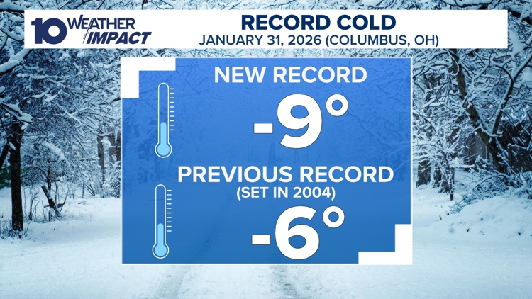

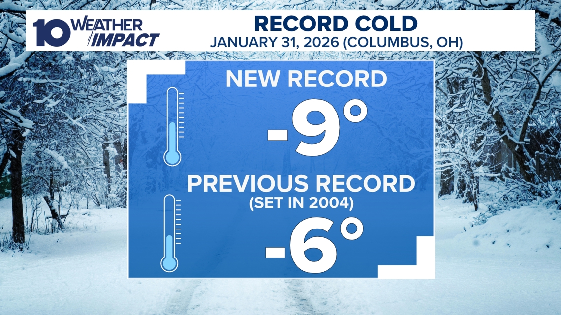
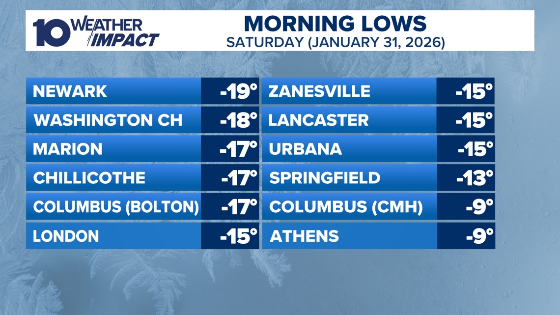
Record‑Breaking –9°F Low Triggers Extended Alert The city of Columbus hit a historic –9°F on Saturday morning, shattering the prior –6°F record and joining other regional stations that reported temperatures in the –10°F to –19°F range with wind chills plunging to –30°F [4][2]. The 10 Weather Impact service declared a Weather Impact Alert Day, extending it through Sunday as the bitter cold persisted [2]. Meteorologists attribute the deep freeze to a surge of arctic air moving south from Canada, which is expected to keep daytime highs below the 20s until the following week [2][3].
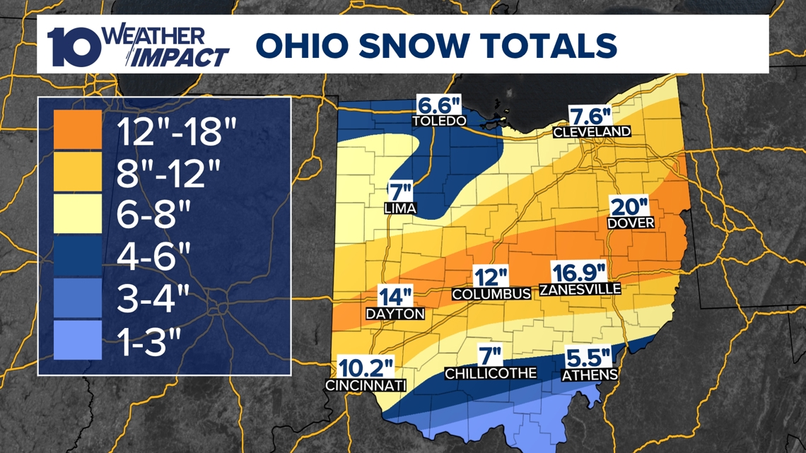
Statewide Snowpack Ranges From Eight to Over Sixteen Inches Snow accumulations across central Ohio vary from 8 inches to more than 16 inches, blanketing the entire state and reinforcing the frigid air mass [2][3]. The deep snow cover is projected to remain throughout the weekend, limiting any rapid temperature recovery [2]. Forecast models indicate that after the Friday system departs, deep‑single‑digit lows and strong winds will generate subzero wind chills on Saturday and Sunday [1]. A gradual warmup is anticipated early next week, with daytime highs potentially reaching the 40s by Tuesday [1][4].
School Districts Close for Fifth Day, Plan Monday Reopen Central Ohio school districts experienced a fifth consecutive day of closures as the winter storm persisted, with Hilliard City Schools canceling classes for the fourth time that week [6]. Parents relied on flexible work arrangements and digital learning tools to manage childcare during the shutdown [6]. By Sunday, most snow emergencies were lifted, and Mayor Andrew Ginther announced that Columbus City Schools are slated to resume classes on Monday, citing improved road conditions reported by the Ohio Department of Public Safety [5].
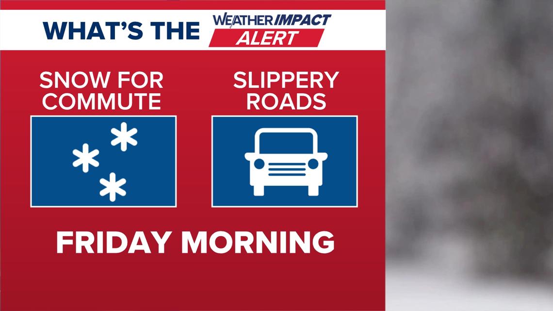
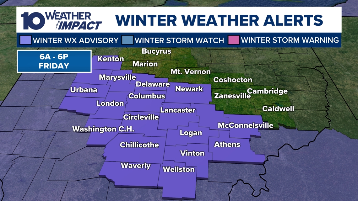
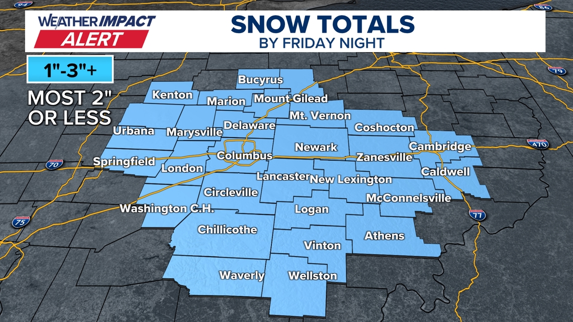
Friday Morning Snow Expected, Weekend Subzero Wind Chill Forecast new winter system will bring 1–2 inches of snow Friday morning, with isolated pockets reaching 3 inches, prompting a Winter Weather Advisory from 6 a.m. to 6 p.m. and a 10 Weather Impact Day alert [1]. The advisory could be cancelled early if the snow clears before 2 p.m., but lingering moisture will still contribute to slippery roads during the commute [1]. After the snowfall ends, deep‑single‑digit temperatures and strong winds will produce subzero wind chills Saturday and Sunday, before a warming trend lifts temperatures above freezing early next week [1][2].
Sources
-
1.
WBNS: Central Ohio Braces for Friday Morning Snow and Weekend Cold: Forecasts 1‑2 inches of snow Friday, heavier during commute, followed by subzero wind chills Saturday‑Sunday and a warming trend early next week .
-
2.
WBNS: Columbus Endures Record Cold as Snowpack Persists, Warmer Weather Expected Next Week: Details the –9°F record low, 8‑16+ inches of snow, extended 10 Weather Impact Alert, and a forecast of temperatures staying below 20°F until next week .
-
3.
WBNS: Columbus Record Low and Snowpack Keep Central Ohio in Deep Freeze: Reinforces the record low and deep snowpack, emphasizing continued arctic air and monitoring via 10 Weather Impact .
-
4.
WBNS: Columbus Sets New Record Low Temperature of –9°F: Reports the –9°F reading at John Glenn Airport, regional –10 to –19°F readings, wind chills –30°F, and a gradual warmup forecast for the coming week .
-
5.
WBNS: Central Ohio Schools Set to Reopen After Snow‑Related Week‑Long Closures: Notes lifted snow emergencies, mayor’s plan for schools to resume Monday, and passable neighborhoods per the Ohio Department of Public Safety .
-
6.
WBNS: Central Ohio Schools Remain Closed as Winter Storm Extends to Fifth Day: Describes the fifth day of school closures, repeated shutdowns in Hilliard City Schools, and families’ coping strategies during the prolonged storm .
Timeline
Dec 2, 2025 – Columbus receives 3‑6 inches of snow, prompting Level 2 and Level 3 snow emergencies that restrict non‑essential travel and close roads to all but emergency vehicles [26].
Dec 2, 2025 – Columbus City Schools cancel Tuesday classes after overnight snowfall makes roads slippery, joining other districts in a region‑wide school shutdown [28].
Dec 2, 2025 – Franklin County courts close Tuesday as 2‑4 inches of snow accumulates, while multiple school districts remain closed under snow‑emergency orders [30].
Dec 5, 2025 – Ohio experiences record‑low wind chills, with temperatures in the single digits and wind‑chill values plunging well below the air temperature, prompting warnings of dangerous outdoor exposure [25].
Dec 12, 2025 – Columbus City Schools cancel several Saturday extracurricular events, citing forecasted 2‑5 inches of snow and expected blowing and drifting conditions that would hinder travel [24].
Dec 14, 2025 – A winter storm drops 1‑9 inches of snow across central Ohio, setting new local records (e.g., 5.4 inches at John Glenn Airport) and ushering in sub‑zero temperatures and wind chills below zero for the following days [23].
Jan 1, 2026 – The 10TV Weather Impact Team issues a Weather Impact Alert Day for up to 2 inches of snow, warning commuters of slippery roads and advising travelers to monitor conditions ahead of Ohio State football games and New Year’s Eve plans [20].
Jan 16, 2026 – The Columbus Metropolitan Library opens a portion of its main branch as a cold‑weather shelter from noon to 9 p.m., providing seating, Wi‑Fi and restrooms while all other branches close for Martin Luther King Jr. Day [19].
Jan 20‑21, 2026 – A Winter Storm Watch covers six southern Ohio counties, forecasting single‑digit temperatures and subzero wind chills from Friday night through Monday, with the strongest wind‑chill impacts expected Friday night into Saturday [18].
Jan 24, 2026 – Gov. Mike DeWine declares a state of emergency ahead of an approaching major winter storm, authorizing rapid procurement of shelters, road‑treatment supplies and emergency equipment, and urges residents to stay home unless travel is essential [17].
Jan 25, 2026 – A massive winter system dumps more than 16 inches of snow across central Ohio, triggers Level 2 and Level 3 snow emergencies, forces Ohio State to cancel Monday‑Tuesday in‑person classes, and leads Kroger and Giant Eagle to close stores early on Sunday as heavy snowfall continues [14][15][9][13][16].
Jan 26, 2026 – The Columbus Blue Jackets postpone their Monday night game against the Los Angeles Kings to March 9 due to a foot of snow and extreme cold, while 10TV launches continuous live coverage of the storm via its free 10TV+ streaming app [11][12].
Jan 27, 2026 – Columbus records a new all‑time low of –9 °F at John Glenn Airport, breaking the previous –6 °F record, with wind chills reaching –30 °F; forecasters project gradual daytime warming into the 20s‑30s the following week [4][10][2][3].
Jan 28, 2026 – Ten central Ohio districts, including Columbus City Schools and Olentangy Schools, announce Thursday closures as Arctic air drives wind‑chill values to –15 °F or lower, maintaining Weather Impact Alert Days through the weekend [8].
Jan 29, 2026 – Schools across central Ohio cancel Friday classes amid brutally cold Arctic air, with morning lows near zero, afternoon highs in the low teens, and wind chills staying at or below zero; Saturday may tie the Jan 31 record low of –6 °F [7][6].
Jan 30, 2026 – After a week of snow‑related closures, most central Ohio counties lift snow emergencies, and Mayor Andrew Ginther announces that Columbus City Schools will reopen on Monday, citing improving road conditions despite lingering extreme cold [5].
Jan 31, 2026 – Columbus officially records the –9 °F low, confirming it as the coldest temperature ever observed on that date, while nearby locations report –10 °F to –19 °F and wind chills of –30 °F, prompting health warnings for frostbite and hypothermia [4].
Feb 2, 2026 – Central Ohio braces for Friday‑morning snow, expecting 1‑2 inches (isolated 3‑inch spots) with slippery roads, followed by deep‑single‑digit lows and subzero wind chills over the weekend; forecasts call for temperatures rising above freezing into the 40s by early next week [1].
Feb 5, 2026 – Updated forecasts confirm the Friday‑morning snow will likely finish by 2 p.m., allowing the Winter Weather Advisory to end early, while the weekend will bring strong winds and subzero wind chills, with a gradual warm‑up to the 40s expected by the following Tuesday [1].
Mar 9, 2026 (planned) – The postponed Columbus Blue Jackets vs. Los Angeles Kings game is rescheduled for this date, with tickets remaining valid for the new matchup [11].
Dive deeper (9 sub-stories)
-
Central Ohio Braces for Light Snow Friday as Temperatures Stay in Low 20s
(14 articles)
-
Central Ohio Schools Set to Reopen Monday After Record Snowstorm and Arctic Freeze
(17 articles)
-
WBNS (Columbus, OH): Central Ohio Schools Remain Closed as Winter Storm Extends to Fifth Day
-
Columbus Zoo Extends Shutdown to Feb. 1 After Record Snowstorm
(3 articles)
-
Ohio Winter Storm Leaves Up to 20 Inches of Snow, Triggers Level 3 Emergencies
(8 articles)
-
DeWine Urges Precautions as Arctic Cold Persists After State‑wide Emergency Declaration
(2 articles)
-
WBNS (Columbus, OH): Columbus Blue Jackets game postponed to March 9 after heavy snowstorm
-
Ohio Endures Record Snowfall as Winter Storm Persists Through Monday
(2 articles)
-
Kroger and Giant Eagle Shut Hundreds of Ohio Stores Early as Snowstorm Deepens
(2 articles)
All related articles (50 articles)
-
WBNS (Columbus, OH): Central Ohio Braces for Friday Morning Snow and Weekend Cold
-
WBNS (Columbus, OH): Columbus Endures Record Cold as Snowpack Persists, Warmer Weather Expected Next Week
-
WBNS (Columbus, OH): Columbus Record Low and Snowpack Keep Central Ohio in Deep Freeze
-
WBNS (Columbus, OH): Columbus Sets New Record Low Temperature of –9°F
-
WBNS (Columbus, OH): Central Ohio Schools Set to Reopen After Snow‑Related Week‑Long Closures
-
WBNS (Columbus, OH): Central Ohio Schools Remain Closed as Winter Storm Extends to Fifth Day
-
WBNS (Columbus, OH): Columbus City Schools Cancel Classes Friday Amid Ongoing Winter Storm and Extreme Cold
-
WBNS (Columbus, OH): Central Ohio Schools Shut Down Friday Amid Arctic Cold
-
WBNS (Columbus, OH): Columbus Zoo Remains Closed Through Feb. 1 Amid Record Snow and Subzero Cold
-
WBNS (Columbus, OH): Central Ohio School Districts Cancel Thursday Classes Amid Arctic Cold
-
WBNS (Columbus, OH): Central Ohio School Districts Close Wednesday Amid Deep Freeze
-
WBNS (Columbus, OH): Ohio Winter Storm Leaves Over 16 Inches of Snow and Triggers Snow Emergencies
-
WBNS (Columbus, OH): Central Ohio Receives Up to 20 Inches of Snow as Major Winter Storm Ends
-
WBNS (Columbus, OH): Ohio Gov. DeWine urges safety measures as Arctic cold grips state
-
WBNS (Columbus, OH): Central Ohio Business and School Closures After Record Snowstorm
-
WBNS (Columbus, OH): Central Ohio School Districts Close Tuesday Amid Heavy Snow and Arctic Cold
-
WBNS (Columbus, OH): Columbus Blue Jackets game postponed to March 9 after heavy snowstorm
-
WBNS (Columbus, OH): Central Ohio schools close Monday as historic snowstorm brings extreme cold
-
WBNS (Columbus, OH): 10TV Extends Live Winter Storm Coverage Across Ohio
-
WBNS (Columbus, OH): Kroger and Giant Eagle close stores early Sunday as Ohio winter storm intensifies
-
WBNS (Columbus, OH): Ohio State cancels in‑person classes Monday‑Tuesday as winter storm hits central Ohio
-
WBNS (Columbus, OH): Giant Eagle Closes All Ohio Stores Early Amid Snowstorm
-
WBNS (Columbus, OH): Ohio Snowstorm Forces Road Closures and Massive Plow Deployment
-
WBNS (Columbus, OH): Cars stuck on I‑70 West as snow intensifies, highways reopen
-
WBNS (Columbus, OH): Ohio Governor Declares State of Emergency Ahead of Major Winter Storm
-
WBNS (Columbus, OH): Columbus Mayor Updates Residents Ahead of Major Winter Storm
-
WBNS (Columbus, OH): DeWine and state officials urge caution as winter storm looms over central Ohio
-
WBNS (Columbus, OH): Central Ohio braces for weekend snow and subzero wind chills as arctic blast returns
-
WBNS (Columbus, OH): Central Ohio schools cancel or delay Tuesday classes amid extreme cold
-
WBNS (Columbus, OH): Columbus Metropolitan Library opens main branch Monday as cold shelter
-
WBNS (Columbus, OH): Columbus Zoo closes Monday amid freezing temperatures
-
WBNS (Columbus, OH): Snow showers expected in central Ohio overnight into Sunday as cold air moves in
-
WBNS (Columbus, OH): Central Ohio braces for up to 2 inches of snow as Weather Impact Alert Day is issued
-
WBNS (Columbus, OH): Snow expected this evening across central and southern Ohio with 1-3 inches of accumulation
-
WBNS (Columbus, OH): Central Ohio braces for 40-50 mph wind gusts Monday as a strong low pressure system moves through
-
WBNS (Columbus, OH): Storm system may bring thunderstorms to central Ohio overnight
-
WBNS (Columbus, OH): Central Ohio schools closed or delayed amid winter weather
-
WBNS (Columbus, OH): Central Ohio school closings: Several districts cancel or delay Monday classes due to winter weather
-
WBNS (Columbus, OH): Columbus City Schools cancels classes, extracurriculars Monday due to inclement weather
-
WBNS (Columbus, OH): Sub-zero wind chills Sunday & Monday after heavy snow Saturday
-
WBNS (Columbus, OH): Winter storm brings several inches of snow to central Ohio: Current snowfall totals
-
WBNS (Columbus, OH): Columbus City Schools cancels some extracurriculars Saturday due to winter weather
-
WBNS (Columbus, OH): Rain, snow and wind impacting Wednesday morning commute in central Ohio
-
WBNS (Columbus, OH): Ohio Experiences Record Low Wind Chills on Friday Morning
-
WBNS (Columbus, OH): Central Ohio Faces Single‑Digit Wind Chill Friday Morning
-
WBNS (Columbus, OH): Columbus, Ohio Receives 3‑6 Inches of Snow After Winter Storm
-
WBNS (Columbus, OH): Central Ohio Receives Up to 5 inches of Snow Tuesday Morning
-
WBNS (Columbus, OH): Franklin County Courts Closed Tuesday Due to Winter Weather
-
WBNS (Columbus, OH): Central Ohio Schools and Courts Cancel Classes and Close on Tuesday Due to Snow
-
WBNS (Columbus, OH): Columbus City Schools Cancel Tuesday Classes Amid Overnight Snow
External resources (20 links)
- https://warriorwatch.columbus.gov/ (cited 2 times)
- http://emergency.osu.edu (cited 1 times)
- https://twitter.com/hashtag/ODOTwinter?src=hash&ref_src=twsrc%5Etfw (cited 3 times)
- http://facebook.com/AaronWhiteTV/ (cited 2 times)
- http://instagram.com/aaronwhitetv/ (cited 2 times)
- http://x.com/AaronWhiteTV (cited 2 times)
- https://t.co/D3AfQbTt0n (cited 1 times)
- https://t.co/kZTfz0pmJJ (cited 1 times)
- https://t.co/y2mdfitzGi (cited 1 times)
- https://t.co/zE47OTcGJ2 (cited 1 times)
- https://www.facebook.com/ColumbusCitySchools (cited 1 times)
- https://www.facebook.com/ohiodrc/posts/pfbid0eQwq1EC4PRv1zc6YYTEmCVgTZEWanfusM6nZS1LEJBYcNYKc6utcpBPJUZK6TCHpl (cited 1 times)
- https://www.facebook.com/photo/?fbid=1539829818143817&set=a.542568367869972 (cited 1 times)
- https://www.facebook.com/share/p/17aHwhEg5Q/ (cited 1 times)
- https://www.facebook.com/share/p/17vsgKJoM9/ (cited 1 times)
- https://www.facebook.com/share/p/188JhExC1c/ (cited 1 times)
- https://portal.snowpaths.com/public/983278/983279 (cited 2 times)
- https://provolleyball.com/news/2026/01/atlanta-at-columbus-mlv-match-postponed (cited 1 times)
- https://snowgo.dublin.oh.us/ (cited 1 times)
- https://tv.10tv.com/ (cited 1 times)