Dense Fog Advisory Issued for Central Ohio Tuesday Amid Approaching Warm Storm
Updated (49 articles)
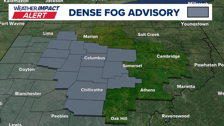
Tuesday Morning Fog Reduces Visibility to Quarter‑Mile dense fog layer moved back across central Ohio on Tuesday morning, limiting visibility to a quarter‑mile or less and prompting a 10TV Weather Impact Alert Day for commuters [1]. The National Weather Service simultaneously issued a Dense Fog Advisory covering the same counties, reinforcing local warnings about hazardous travel conditions [1]. The advisory was released on February 17, 2026, targeting the early‑day rush hour period [1].
Fog Less Extensive Than Monday but Still Hazardous Compared with the widespread fog on Monday, Tuesday’s fog was thinner yet remained dangerous for drivers and pedestrians [1]. Overnight temperatures fell to the mid‑upper 30s, leaving road surfaces wet and slick, which compounded the visibility issue [1]. Authorities warned that even the reduced fog could cause accidents and advised caution on all routes [1].
Meteorologists Cite Soil Moisture and Warm Air Interaction Forecasters attribute the back‑to‑back fog events to cold, moisture‑laden soil from recent snowmelt encountering an influx of warmer air moving into the region [1]. This combination is a classic catalyst for radiation fog formation, especially when nighttime cooling is limited by saturated ground [1]. The same atmospheric setup is expected to influence the upcoming weather pattern later in the week [1].
Upcoming Week Brings Near‑Record Heat and Storms Over the next several days, a windy storm system will push temperatures toward a near‑record 66 °F, matching the 2017 high, while scattered rain showers are forecast for Wednesday and Thursday [1]. A possible thunderstorm may develop Thursday, followed by a cold front on Friday that will clear skies and bring cooler temperatures [1]. The forecast concludes with a chance of snow showers on Sunday as the system exits the region [1].
Timeline
Dec 2, 2025 – Central Ohio receives 3‑6 inches of snow; counties fall under Level 2 and Level 3 snow emergencies, prompting road closures for non‑emergency traffic [26].
Dec 2, 2025 – Snowfall of 3‑5 inches blankets the region; winter‑weather advisories lift as the system moves out, but forecasters note another system approaching the Ohio Valley [27].
Dec 2, 2025 – Columbus City Schools cancel Tuesday classes because overnight snow makes roads slippery, joining other districts in the area [28].
Dec 2, 2025 – Multiple school districts, Columbus State Community College, and Franklin County courts close on Tuesday as snow accumulates 2‑4 inches, citing hazardous conditions [29][30].
Dec 5, 2025 – Record low wind chills hit parts of Ohio, dropping below any previous values for the season and prompting cold‑weather warnings despite a modest daytime warm‑up forecast [25].
Dec 15, 2025 – Several central Ohio districts cancel or delay Monday classes because slick roads from Saturday’s snow persist; forecasts call for warming into the 20s Thursday and a line of showers Friday‑Saturday [24].
Dec 29, 2025 – A strong low‑pressure system drives 40‑50 mph wind gusts across central Ohio, triggering a Weather Impact Alert Day, warnings of power outages, and temperatures that plunge into the low 20s by early Tuesday [23].
Jan 11, 2026 – A cold northwest flow drops temperatures into the 20s overnight, brings light snow showers (up to 0.5 in) and wind chills in the teens‑twenties; sunshine returns with 40 °F highs on Monday and Tuesday [22].
Jan 21, 2026 – A Southern Ohio Winter Storm Watch covers six counties as subzero wind chills are expected Friday night through Monday, with possible snow Saturday night into Sunday; the worst wind‑chill impacts occur Friday night into early Saturday [21].
Jan 21, 2026 – A major winter storm deposits more than 16 inches of snow across central Ohio, prompting Level 2 and Level 3 snow emergencies, subzero wind chills (‑10 °F to ‑20 °F), and Tuesday school cancellations [11].
Jan 25, 2026 – Ohio State University cancels Monday‑Tuesday in‑person classes after the storm drops over 16 inches of snow and forecasts subzero temperatures with wind chills down to ‑20 °F; faculty are urged to shift to virtual instruction [18].
Jan 25, 2026 – Kroger closes 115 Columbus‑area stores early at 6 p.m. and Giant Eagle shuts all Ohio locations at 4 p.m. as snowfall reaches 6‑12 inches and every central Ohio county enters a Level 3 snow emergency [17][19].
Jan 25, 2026 – ODOT deploys over 1,200 snow‑clearing crews as Franklin County enters a Level 2 snow emergency; press secretary Matt Bruning posts real‑time updates on X, and forecasts suggest the storm could rank among Columbus’s top five snow events [20].
Jan 26, 2026 – Central Ohio school districts announce Monday closures as the storm continues, with more than 16 inches of snow and subzero wind chills prompting a Weather Impact Alert for extreme cold [16].
Jan 26, 2026 – The Columbus Blue Jackets postpone their Monday night game against the Los Angeles Kings to March 9, citing 8‑16 inches of snow and wind chills near ‑20 °F; tickets remain valid for the new date [15].
Jan 26, 2026 – Multiple districts close schools Tuesday after 8‑16 inches of snow, with wind chills expected around ‑20 °F and subzero temperatures persisting through the week, keeping Weather Impact Alerts active [14].
Jan 27, 2026 – Over 30 central Ohio districts cancel Wednesday classes as snow totals range from 8‑16 inches, extreme cold stays below 20 °F, and daily Weather Impact alerts run through Sunday [10].
Jan 28, 2026 – Ten districts cancel Thursday classes as wind chills dip to ‑15 °F or lower; a modest warming trend is forecast early next week, and a full closure list remains online [9].
Jan 28, 2026 – The Columbus Zoo announces it will remain closed through Feb 1 to protect guests, staff, and animals amid more than 16 inches of snow and ongoing subzero temperatures, calling safety its top priority [8].
Jan 29, 2026 – Central Ohio schools cancel Friday classes due to arctic cold with subzero wind chills; Saturday may tie the Jan 31 record low of ‑6 °F, and Sunday ends subzero mornings as temperatures rise to the upper teens, beginning a warming trend [7].
Jan 29, 2026 – Fifth consecutive day of school closures prompts parents like Allison Rana to rely on remote‑work flexibility and iPads for student learning, while students find creative ways to pass time, illustrating the storm’s social impact [6].
Jan 31, 2026 – Columbus records a new all‑time low of ‑9 °F, breaking the previous ‑6 °F record; wind chills plunge to ‑30 °F, and meteorologist Aaron White notes a forecast of gradual warm‑up into the 20s‑30s next week [5].
Feb 1, 2026 – The record low of ‑9 °F persists, snowpack reaches 8‑16+ inches, and Canadian arctic air keeps temperatures below 20 °F through the weekend, extending the deep freeze [3][4].
Feb 2, 2026 – Snow returns Friday with 1‑3 inches across central Ohio, followed by bitter cold wind chills; a slight warm‑up on Sunday and gradual warming into the 30s‑40s early next week are forecast, though rain/snow chances linger mid‑week [2].
Feb 17, 2026 – A dense fog advisory triggers a Weather Impact Alert for Tuesday morning as saturated soils meet warm air, reducing visibility to a quarter‑mile; forecasters warn of a warm storm with near‑record 66 °F heat, scattered rain Wednesday‑Thursday, possible thunderstorm Thursday, a cold front Friday, and snow showers Sunday [1].
Dive deeper (9 sub-stories)
-
Dense Fog Advisory Issued for Central Ohio Tuesday Amid Warm‑Front Forecast
(11 articles)
-
Columbus Hits Record –9°F as Snowpack Deepens, Cold Wave Extends Through Weekend
(3 articles)
-
Central Ohio Schools Set to Reopen Monday After Record Snowstorm and Arctic Freeze
(17 articles)
-
WBNS (Columbus, OH): Central Ohio Schools Remain Closed as Winter Storm Extends to Fifth Day
-
Columbus Zoo Extends Shutdown to Feb. 1 After Record Snowstorm
(3 articles)
-
Ohio Winter Storm Dumps Up to 20 Inches, Triggers County Emergencies and School Closures
(9 articles)
-
WBNS (Columbus, OH): Columbus Blue Jackets game postponed to March 9 after heavy snowstorm
-
Ohio Endures Record Snowfall as Winter Storm Persists Through Monday
(2 articles)
-
Kroger and Giant Eagle Shut Hundreds of Ohio Stores Early as Snowstorm Deepens
(2 articles)
All related articles (49 articles)
-
WBNS (Columbus, OH): Dense Fog Advisory Triggers Weather Impact Alert for Central Ohio Tuesday
-
WBNS (Columbus, OH): Snow Returns to Central Ohio as Bitter Cold Lingers, Forecast Calls for Gradual Warm‑up
-
WBNS (Columbus, OH): Columbus Endures Record Cold as Snowpack Persists, Warmer Weather Expected Next Week
-
WBNS (Columbus, OH): Columbus Record Low and Snowpack Keep Central Ohio in Deep Freeze
-
WBNS (Columbus, OH): Columbus Sets New Record Low Temperature of –9°F
-
WBNS (Columbus, OH): Central Ohio Schools Set to Reopen After Snow‑Related Week‑Long Closures
-
WBNS (Columbus, OH): Central Ohio Schools Remain Closed as Winter Storm Extends to Fifth Day
-
WBNS (Columbus, OH): Columbus City Schools Cancel Classes Friday Amid Ongoing Winter Storm and Extreme Cold
-
WBNS (Columbus, OH): Central Ohio Schools Shut Down Friday Amid Arctic Cold
-
WBNS (Columbus, OH): Columbus Zoo Remains Closed Through Feb. 1 Amid Record Snow and Subzero Cold
-
WBNS (Columbus, OH): Central Ohio School Districts Cancel Thursday Classes Amid Arctic Cold
-
WBNS (Columbus, OH): Central Ohio School Districts Close Wednesday Amid Deep Freeze
-
WBNS (Columbus, OH): Ohio Winter Storm Leaves Over 16 Inches of Snow and Triggers Snow Emergencies
-
WBNS (Columbus, OH): Central Ohio Receives Up to 20 Inches of Snow as Major Winter Storm Ends
-
WBNS (Columbus, OH): Central Ohio Business and School Closures After Record Snowstorm
-
WBNS (Columbus, OH): Central Ohio School Districts Close Tuesday Amid Heavy Snow and Arctic Cold
-
WBNS (Columbus, OH): Columbus Blue Jackets game postponed to March 9 after heavy snowstorm
-
WBNS (Columbus, OH): Central Ohio schools close Monday as historic snowstorm brings extreme cold
-
WBNS (Columbus, OH): 10TV Extends Live Winter Storm Coverage Across Ohio
-
WBNS (Columbus, OH): Kroger and Giant Eagle close stores early Sunday as Ohio winter storm intensifies
-
WBNS (Columbus, OH): Ohio State cancels in‑person classes Monday‑Tuesday as winter storm hits central Ohio
-
WBNS (Columbus, OH): Giant Eagle Closes All Ohio Stores Early Amid Snowstorm
-
WBNS (Columbus, OH): Ohio Snowstorm Forces Road Closures and Massive Plow Deployment
-
WBNS (Columbus, OH): Cars stuck on I‑70 West as snow intensifies, highways reopen
-
WBNS (Columbus, OH): Columbus Mayor Updates Residents Ahead of Major Winter Storm
-
WBNS (Columbus, OH): DeWine and state officials urge caution as winter storm looms over central Ohio
-
WBNS (Columbus, OH): Central Ohio braces for weekend snow and subzero wind chills as arctic blast returns
-
WBNS (Columbus, OH): Central Ohio schools cancel or delay Tuesday classes amid extreme cold
-
WBNS (Columbus, OH): Columbus Metropolitan Library opens main branch Monday as cold shelter
-
WBNS (Columbus, OH): Columbus Zoo closes Monday amid freezing temperatures
-
WBNS (Columbus, OH): Snow showers expected in central Ohio overnight into Sunday as cold air moves in
-
WBNS (Columbus, OH): Central Ohio braces for up to 2 inches of snow as Weather Impact Alert Day is issued
-
WBNS (Columbus, OH): Snow expected this evening across central and southern Ohio with 1-3 inches of accumulation
-
WBNS (Columbus, OH): Central Ohio braces for 40-50 mph wind gusts Monday as a strong low pressure system moves through
-
WBNS (Columbus, OH): Storm system may bring thunderstorms to central Ohio overnight
-
WBNS (Columbus, OH): Central Ohio schools closed or delayed amid winter weather
-
WBNS (Columbus, OH): Central Ohio school closings: Several districts cancel or delay Monday classes due to winter weather
-
WBNS (Columbus, OH): Columbus City Schools cancels classes, extracurriculars Monday due to inclement weather
-
WBNS (Columbus, OH): Sub-zero wind chills Sunday & Monday after heavy snow Saturday
-
WBNS (Columbus, OH): Winter storm brings several inches of snow to central Ohio: Current snowfall totals
-
WBNS (Columbus, OH): Columbus City Schools cancels some extracurriculars Saturday due to winter weather
-
WBNS (Columbus, OH): Rain, snow and wind impacting Wednesday morning commute in central Ohio
-
WBNS (Columbus, OH): Ohio Experiences Record Low Wind Chills on Friday Morning
-
WBNS (Columbus, OH): Central Ohio Faces Single‑Digit Wind Chill Friday Morning
-
WBNS (Columbus, OH): Columbus, Ohio Receives 3‑6 Inches of Snow After Winter Storm
-
WBNS (Columbus, OH): Central Ohio Receives Up to 5 inches of Snow Tuesday Morning
-
WBNS (Columbus, OH): Franklin County Courts Closed Tuesday Due to Winter Weather
-
WBNS (Columbus, OH): Central Ohio Schools and Courts Cancel Classes and Close on Tuesday Due to Snow
-
WBNS (Columbus, OH): Columbus City Schools Cancel Tuesday Classes Amid Overnight Snow
External resources (20 links)
- https://warriorwatch.columbus.gov/ (cited 2 times)
- http://emergency.osu.edu (cited 1 times)
- https://twitter.com/hashtag/ODOTwinter?src=hash&ref_src=twsrc%5Etfw (cited 3 times)
- http://facebook.com/AaronWhiteTV/ (cited 2 times)
- http://instagram.com/aaronwhitetv/ (cited 2 times)
- http://x.com/AaronWhiteTV (cited 2 times)
- https://t.co/D3AfQbTt0n (cited 1 times)
- https://t.co/kZTfz0pmJJ (cited 1 times)
- https://t.co/y2mdfitzGi (cited 1 times)
- https://t.co/zE47OTcGJ2 (cited 1 times)
- https://www.facebook.com/ColumbusCitySchools (cited 1 times)
- https://www.facebook.com/ohiodrc/posts/pfbid0eQwq1EC4PRv1zc6YYTEmCVgTZEWanfusM6nZS1LEJBYcNYKc6utcpBPJUZK6TCHpl (cited 1 times)
- https://www.facebook.com/photo/?fbid=1539829818143817&set=a.542568367869972 (cited 1 times)
- https://www.facebook.com/share/p/17aHwhEg5Q/ (cited 1 times)
- https://www.facebook.com/share/p/17vsgKJoM9/ (cited 1 times)
- https://www.facebook.com/share/p/188JhExC1c/ (cited 1 times)
- https://portal.snowpaths.com/public/983278/983279 (cited 2 times)
- https://provolleyball.com/news/2026/01/atlanta-at-columbus-mlv-match-postponed (cited 1 times)
- https://snowgo.dublin.oh.us/ (cited 1 times)
- https://tv.10tv.com/ (cited 1 times)