High‑Pressure Ridge Brings Nationwide Warmth After Late‑January Storm
Updated (25 articles)

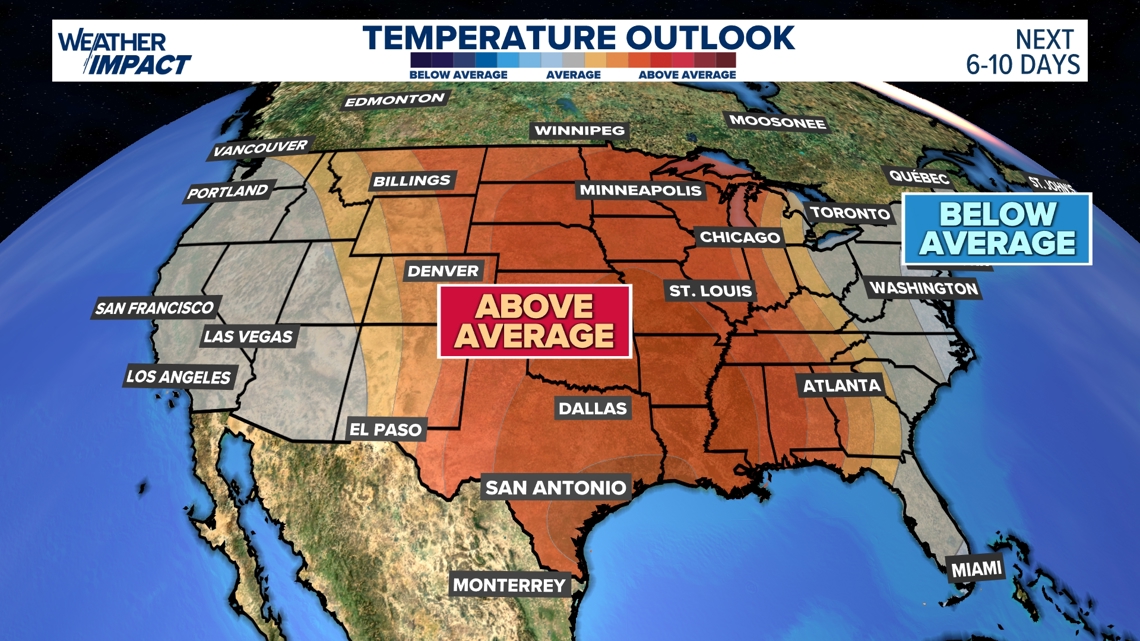
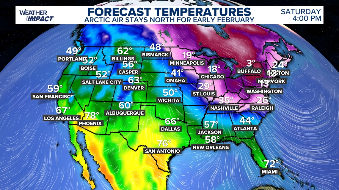
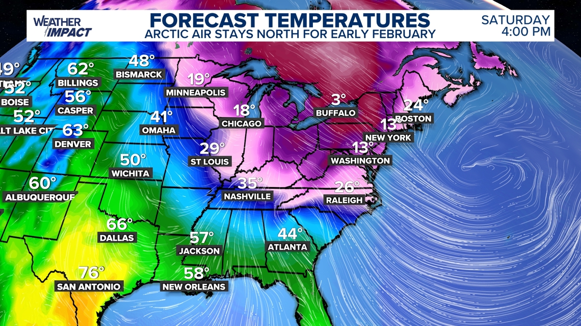
Warm Ridge Replaces Arctic Air Across Most of the U.S. strengthening high‑pressure ridge began dominating the continental United States on February 4, displacing the persistent Arctic air that had defined January and delivering the first widespread above‑average temperatures in several weeks [1]. The ridge’s subsidence of warm air is expected to raise daily highs well above seasonal norms, offering a noticeable break from the harsh winter conditions that preceded it. Meteorologists note that the ridge’s influence will expand eastward over the next few days, setting the stage for a milder February.
Northeast and Midwest Remain Cold Due to Slow‑Moving Trough Despite the ridge’s overall warming effect, a deepening trough lingers over the Northeast and parts of the Midwest, keeping temperatures in the single digits with wind chills that plunge even lower [1]. This trough moves slowly eastward, allowing a pocket of Arctic air to persist into the second week of February. Forecast models show the cold pocket will gradually erode as the ridge fully asserts itself, but residents in New England and the Upper Midwest should expect continued winter‑like conditions for several more days.
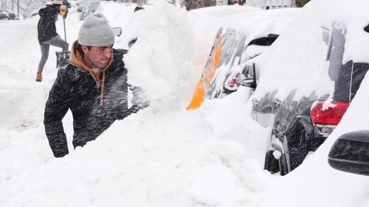
Late‑January Storm Delivered Ice, Snow, and Power Outages Nationwide From January 28 to early February, a powerful winter storm swept from New Mexico to New England, producing freezing rain, sleet, and more than a foot of snow in parts of the Midwest and Northeast [2][3]. The ice accumulation downed tree branches and power lines, leaving hundreds of thousands without electricity across the South, Midwest, and Northeast. The storm’s rapid development and widespread impacts strained local infrastructure and highlighted vulnerabilities in power grids.
Polar Vortex Stretch and Warm Gulf Moisture Fueled Storm Intensity Scientists explained that a southward stretch of the stratospheric polar vortex overlapped a deep jet‑stream dip, creating a conduit for Arctic air to surge south while atmospheric waves bounced energy back into the troposphere, intensifying the storm [2][3]. Simultaneously, unusually warm Gulf‑of‑Mexico sea‑surface temperatures supplied abundant moisture, amplifying precipitation rates. Researchers such as Matthew Barlow (UMass Lowell) and Judah Cohen (MIT) emphasized that climate change produces mixed signals: overall snow totals decline, yet the most extreme storms may grow stronger due to vortex disruptions and warmer oceans [2][3].
Mid‑February Forecast Projects 10‑20°F Above Seasonal Norms As the ridge consolidates, temperature projections for mid‑February show highs 10 to 20 °F above average across central and eastern United States [1]. The temporary warm spell offers relief to communities still recovering from the late‑January storm’s damage, easing heating demands and allowing repair crews to restore power more efficiently. While winter is not over, the forecast suggests a pronounced pause in severe cold before the season’s final phases.
Sources
-
1.
King5: Warmer Temperatures Expected Across Much of the U.S. as High‑Pressure Ridge Builds – Details the emergence of a high‑pressure ridge delivering nationwide warmth, while noting the Northeast’s lingering cold due to a slow‑moving trough .
-
2.
WBNS: How a Polar Vortex Stretch and Warm Gulf Fueled the Late‑January 2026 U.S. Winter Storm – Analyzes the January storm’s dynamics, linking a southward polar vortex stretch and Gulf moisture to its severity, and discusses climate‑change implications and NCAR funding concerns .
-
3.
King5: Polar vortex stretch and warm Gulf boost Jan 2026 U.S. winter storm – Mirrors WBNS’s analysis with added commentary from scientists Barlow and Cohen, emphasizing atmospheric wave interactions and the role of federal research labs .
Timeline
Jan 2019 – The United States experiences a historic Arctic cold wave, with Chicago plunging to –23 °F, rail tracks warping, schools closing and wind‑chill values below –50 °F, illustrating the severe impacts of a polar‑vortex outbreak [17][25].
July 2025 – A study co‑authored by MIT’s Judah Cohen links increased stretching of the polar vortex to more extreme winter weather in the mid‑latitudes, highlighting the role of Arctic sea‑ice loss in the Barents and Kara seas [9].
Late Nov 2025 – The polar vortex weakens and slides southward, allowing a frigid Arctic air mass to spill into the Plains, Midwest, Great Lakes and Northeast [2].
Dec 1, 2025 – Chicago records the coldest early‑winter temperature since 1876, with forecasts calling for a –14 °F low that matches the 1876 record [8].
Dec 3‑4, 2025 – An Arctic air mass descends across the U.S., affecting roughly 200 million people; Des Moines and Cedar Rapids set daily‑low records of –11 °F and –7 °F, while wind chills reach –10 °F to –25 °F [2].
Dec 8‑14, 2025 – The National Weather Service forecasts a new Arctic blast for the Northeast, with wind chills below zero, potential record lows such as –3 °F in Madison, Wisconsin, and multiple Arctic waves moving through the region [7].
Dec 9, 2025 – Experts warn the upcoming Arctic surge could produce the coldest December temperatures in the Eastern U.S.; a stretched vortex between East Asia and North America is identified as the driver [16].
Dec 12‑14, 2025 – Additional Arctic waves are expected, bringing subzero wind chills across the Northeast and Midwest and prompting a series of cold‑weather advisories [6][7].
Dec 13, 2025 – Extreme‑cold warnings cover North Dakota, West Virginia and Virginia; subzero highs threaten the Upper Midwest, and the USPS alerts to mail‑delivery disruptions in 13 states [5].
Dec 27, 2025 – Two potent cold fronts plunge into the northern U.S. as 2025 ends, flipping the lake‑effect snow machine on, causing >650 flight delays, >600 cancellations, and power outages for >30,000 customers in Michigan; NWS maps show below‑average temps Jan 1‑5 2026 [4].
Jan 5, 2026 – A reconfigured jet stream pushes milder air northward, delivering record warmth to ~240 million Americans, with Texas highs in the mid‑80s and Midwest temperatures 20‑30 °F above normal; the Climate Prediction Center projects this warmth through mid‑January [15][23].
Jan 12, 2026 – A powerful Arctic surge spills into the Midwest and East, first hitting the Great Lakes Tuesday night; a second front arrives early weekend with subzero wind chills, 40 mph gusts, and snow totals exceeding a foot in parts of the Northeast [14][22].
Jan 13, 2026 – Scientists explain that mid‑January is climatologically the coldest period because seasonal lag, snow‑albedo feedback, and a strengthening polar jet stream drive Arctic air southward [13][21].
Jan 15, 2026 – An Arctic blast dominates the forecast for central Ohio, keeping highs in the 20s, wind chills of –5 °F to –15 °F, and prompting a Weather Impact Alert Day and a NWS Cold Weather Advisory [11].
Jan 19, 2026 – The Arctic blast reaches the South, bringing cold rain, freezing rain, ice and occasional snow to Texas, Louisiana, Arkansas and the Southeast; temperatures sit 20‑30 °F below normal, prompting travel warnings and vehicle‑winterization advisories [12][20].
Jan 21, 2026 – A stretched polar vortex, amplified by record‑low Arctic sea‑ice, positions its center near Duluth, Minnesota, projecting minus 25 °F to minus 30 °F for two‑thirds of the U.S.; about 230 million people face 20 °F or colder, with 150 million under snow or ice threats [9].
Jan 22, 2026 – A brutal winter storm forms east of the Rockies as Arctic air collides with warm, moist Gulf flow; experts note that a warming climate does not preclude severe cold and that vortex stretching may have “loaded the dice” for this event [1].
Jan 24, 2026 – NASA satellites capture the storm’s massive cloud shield as it expands from the Plains to cover roughly 50 % of the nation, prompting travel advisories, states of emergency in >12 states, 8,000+ flight cancellations and power‑outage risks for ~140 million people [3].
Jan 28, 2026 – The late‑January storm blankets the U.S. with ice, snow and power outages from New Mexico to New England; a southward‑stretched stratospheric vortex and unusually warm Gulf‑of‑Mexico waters supply abundant moisture, illustrating how climate change can intensify the most extreme winter storms [10][19].
Feb 4, 2026 – A strengthening high‑pressure ridge ushers in nationwide milder air after weeks of Arctic cold, while a lingering trough keeps the Northeast chilly; mid‑February highs are expected 10‑20 °F above average, offering a temporary reprieve for storm‑hit communities [18].
Dive deeper (6 sub-stories)
-
High‑Pressure Ridge Brings Nationwide Warm Spell While Northeast Remains Frigid
(2 articles)
-
Polar Vortex Stretch and Warm Gulf Drive Late‑January 2026 U.S. Winter Storm
(5 articles)
-
NASA Images Reveal Half‑Nation Winter Storm Fueled by Arctic Air Surge
(13 articles)
-
Mid‑January Confirmed as Coldest Period in U.S. Due to Seasonal Lag
(2 articles)
-
Winter Pause: Record Warmth Hits 240 Million Americans in Early January
(2 articles)
-
Newsweek: Chicago Faces Coldest Early Winter in 150 Years
All related articles (25 articles)
-
King5 (Seattle, WA): Warmer Temperatures Expected Across Much of the U.S. as High‑Pressure Ridge Builds
-
WBNS (Columbus, OH): How a Polar Vortex Stretch and Warm Gulf Fueled the Late‑January 2026 U.S. Winter Storm
-
King5 (Seattle, WA): Polar vortex stretch and warm Gulf boost Jan 2026 U.S. winter storm
-
Newsweek: NASA Satellite Images Track Expansive U.S. Winter Storm
-
CNN: Winter storm tests climate-change link as polar vortex stretches across the U.S.
-
AP: Stretched polar vortex to deliver brutal winter across much of the U.S.
-
WBNS (Columbus, OH): Arctic blast brings subzero wind chills to central Ohio through Tuesday
-
WBNS (Columbus, OH): Arctic blast forecast to bring ice and cold rain to the South this weekend
-
King5 (Seattle, WA): Arctic blast to bring cold rain and ice to the South this weekend
-
WBNS (Columbus, OH): Mid-January identified as the coldest period of the year due to seasonal lag
-
King5 (Seattle, WA): Mid-January marks the coldest period on long-term averages
-
WBNS (Columbus, OH): Arctic air surge to bring deep cold and snow to Midwest and East this week
-
King5 (Seattle, WA): Arctic air surge to sweep Midwest and East with heavy snow forecast
-
WBNS (Columbus, OH): Record warmth grips most of the U.S. as winter takes a break
-
King5 (Seattle, WA): Record warmth blankets most of the U.S. as winter takes a break
-
Newsweek: Arctic blast to start 2026 with dangerous cold and travel disruptions
-
Newsweek: Polar Vortex Brings Extreme Cold Across Central and Eastern U.S.
-
Newsweek: Polar Vortex Forecast: Near Record Cold Expected Through Sunday Across Midwest and East
-
WBNS (Columbus, OH): Arctic blast could bring the coldest December temperatures to the Eastern U.S.
-
King5 (Seattle, WA): Arctic blast could bring coldest temperatures of the season to parts of the U.S.
-
Newsweek: Polar Vortex Forecast: Fresh Arctic Blast Expected Dec. 12‑14 Across Northeast
-
CNN: Arctic Air Mass Brings Record Cold to Midwest and Northeast
-
WBNS (Columbus, OH): Polar Vortex Outbreaks and Their Impact on North America
-
King5 (Seattle, WA): Polar Vortex: How a Stratospheric Whirlpool Drives Record‑Cold Outbreaks
-
Newsweek: Chicago Faces Coldest Early Winter in 150 Years
External resources (46 links)
- https://forecast.weather.gov/wwamap/wwatxtget.php?cwa=usa&wwa=Extreme%20Cold%20Warning (cited 2 times)
- https://forecast.weather.gov/wwamap/wwatxtget.php?cwa=usa&wwa=Extreme%20Cold%20Watch (cited 2 times)
- https://forecast.weather.gov/wwamap/wwatxtget.php?cwa=usa&wwa=Freezing%20Fog%20Advisory (cited 2 times)
- https://svs.gsfc.nasa.gov/3864 (cited 2 times)
- https://www.cpc.ncep.noaa.gov/products/predictions/814day/ (cited 2 times)
- https://www.noaa.gov/jetstream/global/jet-stream (cited 2 times)
- https://www.weather.gov/source/crh/snowmap.html (cited 2 times)
- https://www.cpc.ncep.noaa.gov/products/predictions/610day/ (cited 1 times)
- https://www.weather.gov/lot/ord_rfd_monthly_yearly_normals (cited 1 times)
- https://doi.org/10.1007/s00382-025-08011-0 (cited 2 times)
- https://doi.org/10.1038/s43247-023-01008-9 (cited 2 times)
- https://doi.org/10.1073/pnas.2510029122 (cited 2 times)
- https://doi.org/10.1126/sciadv.adq9557 (cited 2 times)
- https://doi.org/10.1126/science.abi9167 (cited 2 times)
- https://web.archive.org/web/20250117041847/https://www.climate.gov/news-features/understanding-climate/understanding-arctic-polar-vortex (cited 2 times)
- https://www.ap.org/about/standards-for-working-with-outside-groups/ (cited 1 times)
- https://www.ap.org/discover/Supporting-AP (cited 1 times)
- https://bsky.app/profile/nws.noaa.gov/post/3md7cjvzq5f2o (cited 2 times)
- https://www.instagram.com/rshoptaughwx/?hl=en (cited 2 times)
- https://www.tiktok.com/tag/cold?refer=embed (cited 1 times)
- https://www.tiktok.com/tag/fyp?refer=embed (cited 1 times)
- https://www.tiktok.com/tag/ohio?refer=embed (cited 1 times)
- https://www.tiktok.com/tag/ohwx?refer=embed (cited 1 times)
- https://www.tiktok.com/tag/weather?refer=embed (cited 1 times)
- https://x.com/NWS/status/1999264196995817875 (cited 1 times)
- https://x.com/RyanMaue/status/1995196840787202538/photo/1 (cited 1 times)
- https://climatereanalyzer.org/clim/sst_daily/?dm_id=gomex (cited 2 times)
- https://journals.ametsoc.org/view/journals/bams/98/1/bams-d-15-00212.1.xml (cited 2 times)
- https://s.yimg.com/ny/api/res/1.2/DIFG4P.m2dfKLvlCXPcS.A--/YXBwaWQ9aGlnaGxhbmRlcjt3PTEyNDI7aD02NzQ-/https://media.zenfs.com/en/aol_fox_weather_976/800e35006a051604981dc7910e23158f (cited 2 times)
- https://scholar.google.com/citations?user=kc2doosAAAAJ&hl=en (cited 2 times)
- https://scholar.google.com/citations?user=qWV-WIQAAAAJ&hl=en (cited 2 times)
- https://theconversation.com/how-the-polar-vortex-and-warm-ocean-intensified-a-major-us-winter-storm-274243 (cited 2 times)
- https://theconversation.com/the-western-us-is-in-a-snow-drought-and-storms-have-been-making-it-worse-272549 (cited 2 times)
- https://weather.com/news/weather/news/2026-01-25-live-updates-january-25-winter-storm-fern (cited 2 times)
- https://www.denverpost.com/2026/01/15/colorado-ncar-funding-john-hickenlooper-michael-bennet-senate/ (cited 2 times)
- https://www.ipcc.ch/report/ar6/syr/ (cited 2 times)
- https://www.ipcc.ch/report/ar6/wg1/chapter/chapter-11/ (cited 2 times)
- https://www.ipcc.ch/report/ar6/wg1/chapter/chapter-9/ (cited 2 times)
- https://www.nature.com/articles/ngeo2783 (cited 2 times)
- https://www.nature.com/articles/s41612-018-0054-4 (cited 2 times)
- https://agupubs.onlinelibrary.wiley.com/doi/full/10.1029/2024GL108195 (cited 1 times)
- https://frigid temperatures, massive snow and deadly ice storm (cited 1 times)
- https://nsidc.org/data/seaice_index/images/daily_images/N_iqr_timeseries.png (cited 1 times)
- https://www.accuweather.com/en/winter-weather/millions-brace-for-mother-lode-of-cold-air-but-a-change-is-in-sight-for-central-eastern-us/1842797 (cited 1 times)
- https://www.climatecentral.org/climate-matters/coldest-days-warming-up (cited 1 times)
- https://www.science.org/doi/10.1126/sciadv.adq9557 (cited 1 times)