Snow Alert Issued for Monday Morning Commute as 1‑3 Inches Expected Across Columbus
Updated (15 articles)
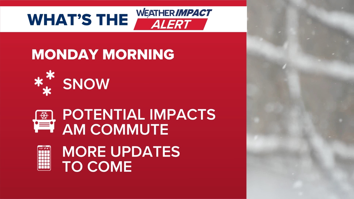

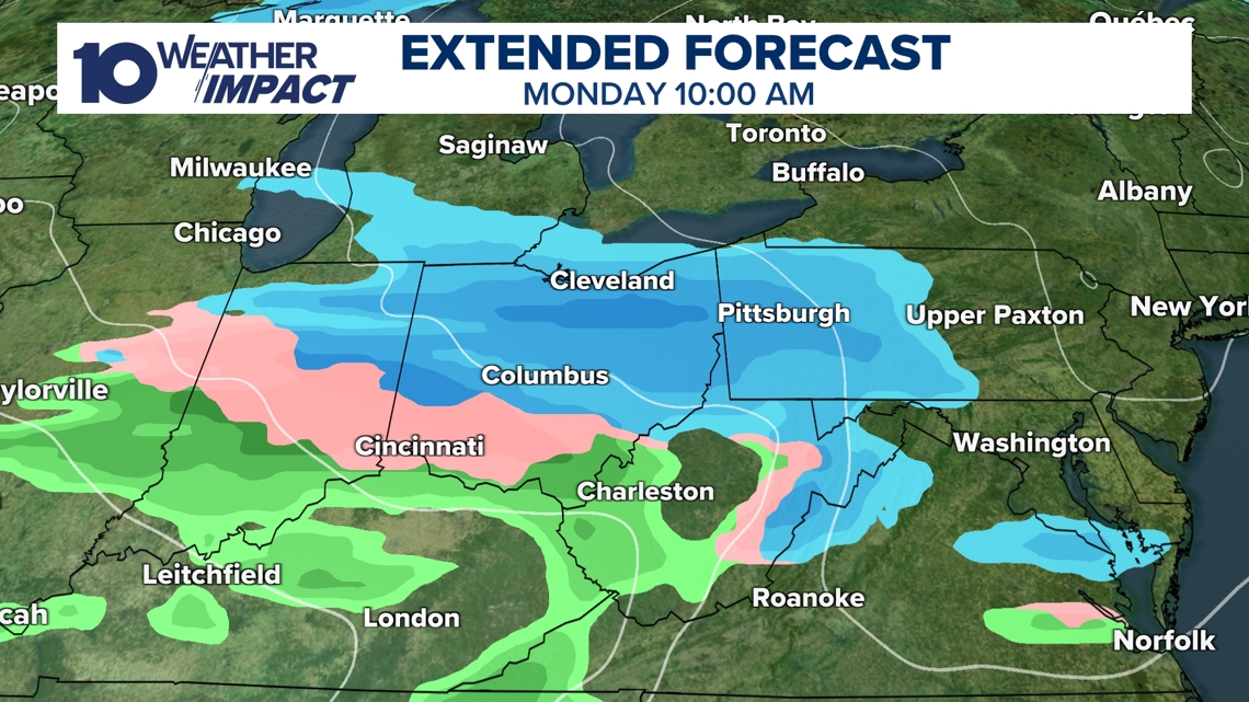
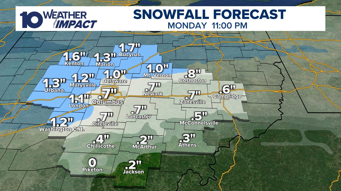
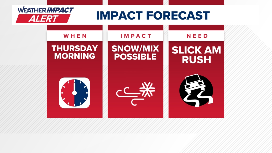
Snow‑Impact Alert Declared for Monday Morning The 10 Weather Impact team announced an Alert Day for the Monday commute, warning schools and workplaces of hazardous travel conditions. Forecast models show snow beginning Sunday night and persisting into the early hours of Monday, with accumulations of 1‑3 inches expected across central Ohio. Temperatures will remain in the upper‑30s on Sunday, limiting any melt before the snowfall, and a shift to rain later Monday could further complicate road conditions. [1]
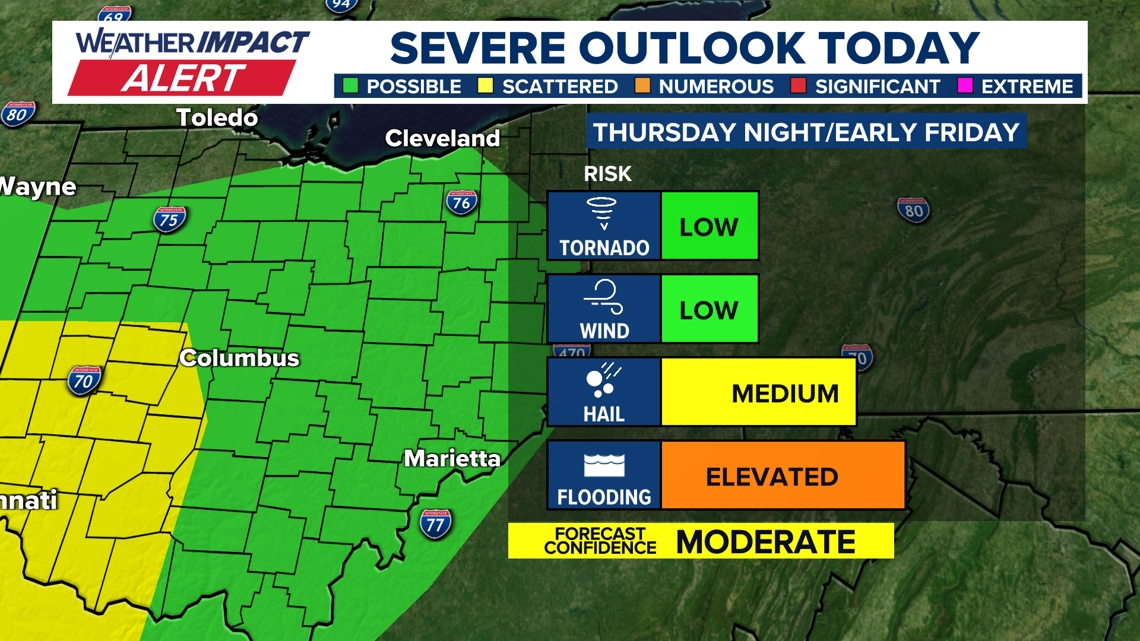
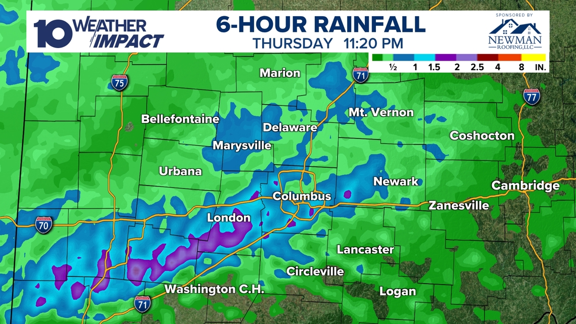
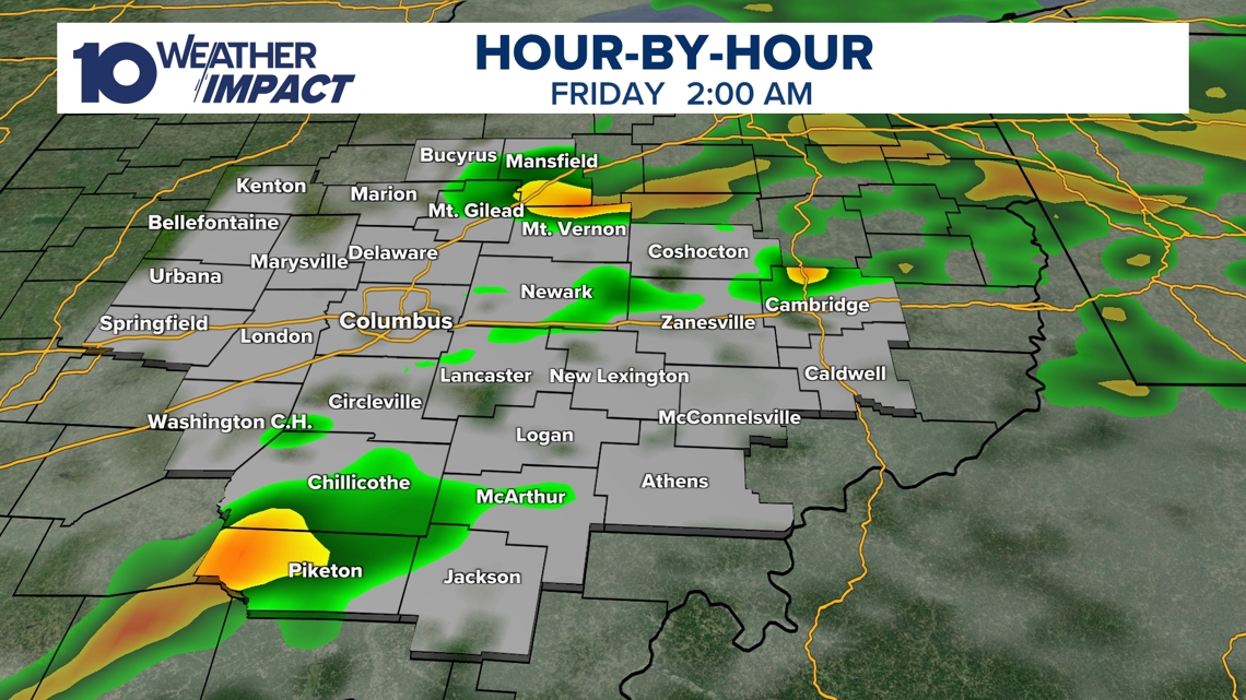
Severe Thunderstorms and Flooding Hit Thursday Night strong storm system entered central Ohio Thursday night, bringing warm, moist air that fueled intense showers and thunderstorms around 9 p.m. Rainfall exceeded 2 inches in several locations by 11:20 p.m., prompting flash‑flood warnings for Fayette and Madison counties through 2 a.m. The event carried a marginal level‑1 severe‑weather risk, with isolated tornadoes not ruled out, before weakening by sunrise Friday. [3][4]
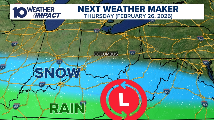
Storm System Shifted South, Thursday Alert Withdrawn By Friday, computer models showed the system moving further south, leading the 10 Weather Impact team to cancel the Thursday Weather Impact Alert. Light rain or snow showers may still affect areas south of I‑70, but no significant accumulation or severe weather is expected. Officials will monitor the situation and issue updates if the system re‑tracks northward. [2]
Forecasts Evolve as Models Refine Storm Track The progression from Thursday’s severe thunderstorms to Friday’s reduced impact and now Monday’s snow illustrates rapid changes in the storm’s trajectory. The 10 Weather Impact team pledged to continue monitoring model outputs and provide timely alerts for any further shifts. Residents are advised to stay informed through regular updates as the situation develops. [1][2]
Sources
-
1.
WBNS (Columbus, OH): Snow Expected Monday Morning Commute in Columbus, Ohio: Announces an Alert Day for Monday’s commute, predicts 1‑3 inches of snow, upper‑30s temperatures, and possible afternoon rain.
-
2.
WBNS (Columbus, OH): Ohio Storm System Shifts South, Reducing Thursday Impact: Reports withdrawal of Thursday’s alert as the system moves south, leaving only light precipitation possible south of I‑70.
-
3.
WBNS (Columbus, OH): Strong Storm System Brings Severe Weather and Flood Risk to Central Ohio: Details Thursday night thunderstorms, over 2 inches of rain, flash‑flood warnings, and marginal severe‑weather risk including isolated tornado potential.
-
4.
WBNS (Columbus, OH): Strong Storm System Moves Through Central Ohio Thursday Night: Mirrors the previous report, emphasizing the shift from wind/hail to flooding, heavy rainfall, and continued alerts through early Friday morning.
Related Tickers
Timeline
Dec 5, 2025 – Ohio records unprecedented low wind chills as temperatures dip into the single digits and teens while winds amplify the cold, prompting Cold Weather Advisories and warning of dangerous outdoor exposure [15].
Dec 9, 2025 – The 10TV Weather Impact team issues an Alert Day for Wednesday, forecasting a rain‑snow mix in the morning, gusty 40 mph winds, and minimal snow accumulation due to near‑freezing temperatures, urging commuters to prepare for slippery roads [14].
Dec 27, 2025 – A strong low‑pressure system moves into the Great Lakes, generating 40‑50 mph gusts across central Ohio on Monday, prompting a Wind Advisory, power‑outage warnings, and advice to secure outdoor items as temperatures plunge into the low 20s [11].
Dec 28, 2025 – Forecasters anticipate a storm system arriving Sunday night into Monday, bringing rain and thunderstorms with a Level 1 severe‑weather risk, a rapid 40‑degree temperature drop, and flash‑freeze hazards on Monday morning [12].
Dec 29, 2025 – The 10TV Weather Impact team alerts central and southern Ohio to evening snow after 4 p.m., estimating 1‑3 inches of accumulation, breezy winds, and wind chills in the teens, and advises travelers heading to the OSU game and New Year’s Eve events to monitor updates [10].
Jan 1, 2026 – A Weather Impact Alert Day warns of up to 2 inches of snow through early night, breezy winds, and wind chills in the teens, targeting OSU game‑goers and New Year’s Eve planners, while radar tracking is offered via the 10TV+ app [9].
Jan 11, 2026 – A cold northwest flow ushers in 20‑degree temperatures and a band of snow showers overnight into Sunday, delivering dustings to a half inch, slick road conditions, and wind chills in the teens and twenties before sunshine lifts highs into the 40s on Monday and Tuesday [8].
Jan 21, 2026 – The National Weather Service issues a Winter Storm Watch for six southern Ohio counties, forecasting subzero wind chills from Friday night through Monday morning, possible snow Saturday evening into Sunday, and Alert Days to warn of hazardous travel and cold stress [7].
Feb 7, 2026 – Snow returns Friday with 1‑3 inches across central Ohio, including isolated 4‑plus‑inch totals, followed by bitter wind chills Saturday, a brief warm‑up Sunday with an additional 1‑2 inch snow band, and a gradual rise into the 30s‑40s early next week, while the 10 Weather Impact team notes repeated rain or snow chances later in the week [6].
Feb 17, 2026 – Dense fog returns Tuesday, reducing visibility to a quarter‑mile, prompting a Weather Impact Alert Day and a National Weather Service Dense Fog Advisory, as saturated soils and warm air create hazardous travel conditions ahead of a warm storm, near‑record 66 °F heat, and a cooling front later in the week [5].
Feb 20, 2026 – A strong storm system moves into central Ohio Thursday night, delivering warm, moist air that fuels thunderstorms around 9 p.m., shifting the threat from wind and hail to heavy rain and flash‑flooding in Fayette and Madison counties, with radar‑estimated totals exceeding 2 inches and gusty winds persisting into Friday morning [3][4].
Feb 24, 2026 – Models show the storm system tracking southward, leading the 10 Weather Impact team to withdraw the Thursday Weather Impact Alert and limit expected impacts to brief light rain or snow south of I‑70, while pledging updates if the system re‑tracks northward [2].
Feb 26, 2026 – The 10 Weather Impact team declares an Alert Day for Monday morning commute as snowfall begins Sunday night, forecasting 1‑3 inches of snow across central Ohio, upper‑30s temperatures, and a possible shift to rain later in the day, with travel disruptions to schools and workplaces expected [1].
Dive deeper (12 sub-stories)
-
WBNS (Columbus, OH): Snow Expected Monday Morning Commute in Columbus, Ohio
-
WBNS (Columbus, OH): Ohio Storm System Shifts South, Reducing Thursday Impact
-
Central Ohio Faces Heavy Rain and Flash Flood Threat Thursday Night
(2 articles)
-
WBNS (Columbus, OH): Dense Fog Advisory Triggers Weather Impact Alert for Central Ohio Tuesday
-
Snow Returns to Central Ohio Friday, Cold Lingers as Forecast Predicts Gradual Warm‑Up
(2 articles)
-
WBNS (Columbus, OH): Central Ohio braces for weekend snow and subzero wind chills as arctic blast returns
-
WBNS (Columbus, OH): Snow showers expected in central Ohio overnight into Sunday as cold air moves in
-
Central Ohio Braces for Up to Two Inches of Snow as Weather Impact Alert Day Begins
(2 articles)
-
WBNS (Columbus, OH): Central Ohio braces for 40-50 mph wind gusts Monday as a strong low pressure system moves through
-
WBNS (Columbus, OH): Storm system may bring thunderstorms to central Ohio overnight
-
WBNS (Columbus, OH): Rain, snow and wind impacting Wednesday morning commute in central Ohio
-
WBNS (Columbus, OH): Ohio Experiences Record Low Wind Chills on Friday Morning
All related articles (15 articles)
-
WBNS (Columbus, OH): Snow Expected Monday Morning Commute in Columbus, Ohio
-
WBNS (Columbus, OH): Ohio Storm System Shifts South, Reducing Thursday Impact
-
WBNS (Columbus, OH): Strong Storm System Brings Severe Weather and Flood Risk to Central Ohio
-
WBNS (Columbus, OH): Strong Storm System Moves Through Central Ohio Thursday Night
-
WBNS (Columbus, OH): Dense Fog Advisory Triggers Weather Impact Alert for Central Ohio Tuesday
-
WBNS (Columbus, OH): Snow Returns to Central Ohio as Bitter Cold Lingers, Forecast Calls for Gradual Warm‑up
-
WBNS (Columbus, OH): Central Ohio braces for weekend snow and subzero wind chills as arctic blast returns
-
WBNS (Columbus, OH): Snow showers expected in central Ohio overnight into Sunday as cold air moves in
-
WBNS (Columbus, OH): Central Ohio braces for up to 2 inches of snow as Weather Impact Alert Day is issued
-
WBNS (Columbus, OH): Snow expected this evening across central and southern Ohio with 1-3 inches of accumulation
-
WBNS (Columbus, OH): Central Ohio braces for 40-50 mph wind gusts Monday as a strong low pressure system moves through
-
WBNS (Columbus, OH): Storm system may bring thunderstorms to central Ohio overnight
-
WBNS (Columbus, OH): Sub-zero wind chills Sunday & Monday after heavy snow Saturday
-
WBNS (Columbus, OH): Rain, snow and wind impacting Wednesday morning commute in central Ohio
-
WBNS (Columbus, OH): Ohio Experiences Record Low Wind Chills on Friday Morning
External resources (8 links)
- https://www.facebook.com/ChrisTomer (cited 3 times)
- https://www.facebook.com/GarofaloWX (cited 3 times)
- https://www.facebook.com/mikebehrenswx (cited 3 times)
- https://www.facebook.com/AaronWhiteTV (cited 2 times)
- http://facebook.com/AaronWhiteTV/ (cited 1 times)
- http://instagram.com/aaronwhitetv/ (cited 1 times)
- http://x.com/AaronWhiteTV (cited 1 times)
- https://www.facebook.com/AaronWhiteTV/ (cited 1 times)